DeSoto County, Mississippi facts for kids
Quick facts for kids
DeSoto County
|
|
|---|---|

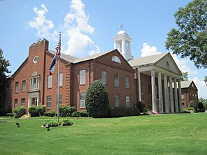
DeSoto County Courthouse
|
|

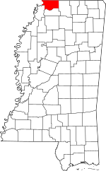
Location within the U.S. state of Mississippi
|
|
 Mississippi's location within the U.S. |
|
| Country | |
| State | |
| Founded | February 9, 1836 |
| Named for | Hernando de Soto |
| Seat | Hernando |
| Largest city | Southaven |
| Area | |
| • Total | 497 sq mi (1,290 km2) |
| • Land | 476 sq mi (1,230 km2) |
| • Water | 21 sq mi (50 km2) 4.2% |
| Population
(2020)
|
|
| • Total | 185,314 |
| • Estimate
(2023)
|
193,247 |
| • Density | 372.9/sq mi (143.96/km2) |
| Time zone | UTC−6 (Central) |
| • Summer (DST) | UTC−5 (CDT) |
| Congressional district | 1st |
DeSoto County is a county in the northwest part of Mississippi. It's right on the border with other states. In 2020, about 185,314 people lived here. This makes it the third-biggest county in Mississippi by population.
The main town, or county seat, is Hernando. DeSoto County is also part of the larger Memphis metropolitan area. It's the second-most populated county in that whole region. The county has flat areas near the river. These were once used for large cotton farms. There are also hills in the eastern part of the county.
Contents
History of DeSoto County
This county is named after Hernando de Soto. He was a Spanish explorer. He was the first European to reach the Mississippi River. The county seat, Hernando, is also named after him.
De Soto may have died in this area in May 1542. Some people think he died near Lake Village, Arkansas. You can find more about his journey here.
Early History and Native Americans
Old tools and items found in DeSoto County show that people lived here long ago. These groups included the Woodland and Mississippian culture peoples. The Mississippian culture built big settlements. They also made large earth mounds along the Mississippi River Valley.
Members of this culture met Hernando de Soto when he explored North Mississippi. Many believe his group traveled through what is now DeSoto County. Some experts think De Soto found the Mississippi River west of Lake Cormorant. They believe he built rafts there and crossed into Arkansas.
The National Park Service has marked a "DeSoto Corridor." This path goes from Memphis to Coahoma County, Mississippi. It is based on old records and discoveries.
The Mississippian culture later faded away. This happened before Europeans arrived in most areas. It might have been due to changes in the environment. The town of Chicasa, which De Soto visited, was likely the home of the Chickasaw people. They were descendants of the Mississippian culture.
The Chickasaw had lived in this area for a long time. White settlers began to arrive later. The town of Pontotoc, Mississippi grew near their "Long Town." This was a group of several villages close together. The Chickasaw claimed much of western Tennessee and northern Mississippi. They used these lands for hunting.
The Chickasaw people traded with the French. France later gave its lands east of the Mississippi River to Britain. This happened after the Seven Years War. The United States then gained these lands when it became independent from Britain.
Geography of DeSoto County
DeSoto County covers about 497 square miles. About 476 square miles are land. The other 21 square miles (4.2%) are water.
Rivers and Lakes
- Mississippi River
- Coldwater River
- Arkabutla Lake
- Chickasaw Bluffs
Main Roads
Neighboring Counties
- Shelby County, Tennessee - to the north
- Crittenden County, Arkansas - to the west
- Tunica County - to the south
- Tate County - to the south
- Marshall County - to the east
Population Information
| Historical population | |||
|---|---|---|---|
| Census | Pop. | %± | |
| 1840 | 7,002 | — | |
| 1850 | 19,042 | 172.0% | |
| 1860 | 23,336 | 22.6% | |
| 1870 | 32,021 | 37.2% | |
| 1880 | 22,924 | −28.4% | |
| 1890 | 24,183 | 5.5% | |
| 1900 | 24,751 | 2.3% | |
| 1910 | 23,130 | −6.5% | |
| 1920 | 24,359 | 5.3% | |
| 1930 | 25,438 | 4.4% | |
| 1940 | 26,663 | 4.8% | |
| 1950 | 24,599 | −7.7% | |
| 1960 | 23,891 | −2.9% | |
| 1970 | 35,885 | 50.2% | |
| 1980 | 53,930 | 50.3% | |
| 1990 | 67,910 | 25.9% | |
| 2000 | 107,199 | 57.9% | |
| 2010 | 161,252 | 50.4% | |
| 2020 | 185,314 | 14.9% | |
| 2023 (est.) | 193,247 | 19.8% | |
| U.S. Decennial Census 1790-1960 1900-1990 1990-2000 2010-2013 |
|||
2020 Census Details
| Race | Number of People | Percentage |
|---|---|---|
| White | 108,466 | 58.53% |
| Black or African American | 55,972 | 30.2% |
| Native American | 298 | 0.16% |
| Asian | 3,023 | 1.63% |
| Pacific Islander | 137 | 0.07% |
| Other/Mixed | 7,257 | 3.92% |
| Hispanic or Latino | 10,161 | 5.48% |
In 2020, there were 185,314 people living in DeSoto County. There were 65,220 households and 47,230 families.
Income Information (2013)
In 2013, the average income for a family was $66,377. The overall average income was $75,875. DeSoto County has the highest average family income in Mississippi. It has the second-highest overall average income, after Madison County.
Fun Places to Visit
DeSoto County is known for its many golf courses.
Velvet Cream, also called 'The Dip', is a famous local restaurant. It has been open since 1947. This makes it the oldest restaurant in the county that is still running. In 2010, USA Today called it the 'Best Ice Cream in Mississippi'.
DeSoto County also used to have Maywood Beach. This was a water park that closed in 2003. It had been open for over 70 years.
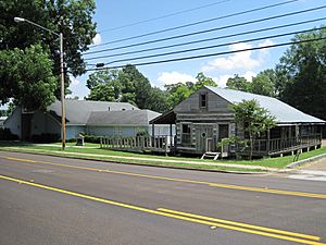
DeSoto County Museum
A popular place to visit is the DeSoto County Museum. It is in Hernando, the county seat. The museum is open from Tuesday to Saturday, 10 AM to 5 PM. It's free to get in, but donations are welcome.
The museum has exhibits about Hernando DeSoto. It also shows history from the Civil War. You can see displays about old French colonial and American homes. There are also exhibits on civil rights and the history of the county's towns.
An old French colonial log house is also at the museum. It shows how people lived when the French traded and settled along the Mississippi River. This house is like others saved in Ste. Genevieve, Missouri. Many French settlers moved there after France gave its land to Great Britain.
Hernando DeSoto Park
Hernando DeSoto Park is located about 6 miles west of Walls. This park is 41 acres big. It has a hiking trail, a view of the river, and picnic areas. There is also a boat launch. It is the only place in DeSoto County where you can easily get to the Mississippi River.
Towns and Communities
Cities
- Hernando (the county seat)
- Horn Lake
- Olive Branch
- Southaven
Towns
Census-Designated Places
These are areas that are like towns but not officially incorporated.
Other Communities
These are smaller, unincorporated communities.
Former Communities
Education in DeSoto County
DeSoto County School District provides public education here. It is the largest school district in Mississippi. The district runs eight high schools and eight middle schools. It also has three intermediate schools (for grades 3-5) and many primary schools.
Famous People from DeSoto County
- Nakobe Dean, plays in the NFL for the Philadelphia Eagles.
- John Grisham, a well-known lawyer and writer.
- Olivia Holt, an actor and singer.
- Jerry Lee Lewis (1935-2022), a famous singer, songwriter, and pianist.
- Cody Reed, an MLB pitcher for the Tampa Bay Rays.
- Austin Riley, an MLB third baseman for the Atlanta Braves.
- Ricky Stenhouse Jr., a NASCAR driver.
Local News and Media
- DeSoto Times-Tribune
- DeSotoCountyNews.com
More to Read
- Map Guide to the U.S. Federal Censuses, 1790–1920, by Thorndale, William, and Dollarhide, William; Copyright 1987. (This book has old maps showing how DeSoto County changed over time.)
See also
 In Spanish: Condado de DeSoto (Misisipi) para niños
 | Delilah Pierce |
 | Gordon Parks |
 | Augusta Savage |
 | Charles Ethan Porter |


