Geography of Paraguay facts for kids
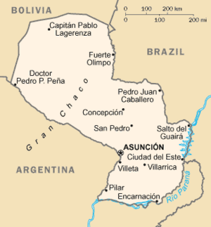
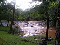
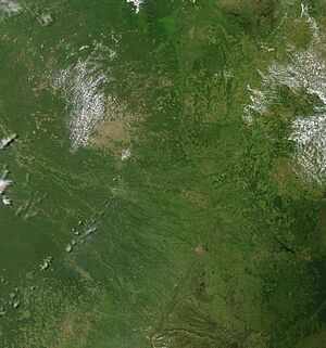
Paraguay is a country in South America. It shares borders with Brazil, Argentina, and Bolivia. The Paraguay River flows through the country. It divides Paraguay into two very different parts: the eastern and western regions.
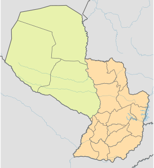
The eastern part is called the Paraneña region. The western part is known as the Chaco. Both areas gently slope towards the Paraguay River. This river acts like a natural divider and also connects the two regions. Paraguay is located near the Tropic of Capricorn. This means it has both subtropical and tropical climates.
Contents
Paraguay's Borders
Paraguay shares its borders with three much larger countries: Bolivia, Brazil, and Argentina. The country has three "tripoints." A tripoint is where the borders of three countries meet. These are:
- Argentina-Bolivia-Paraguay
- Bolivia-Brazil-Paraguay
- Paraguay-Argentina-Brazil
The border with Bolivia in the northwest was decided in 1938. This border runs through the low hills of the Chaco region.
The border between the Chaco and Brazil was set in 1927. It follows the Apa River and then the Paraguay River north to Bolivia.
The northern border of the Paraneña region was set in 1872. It follows the Paraná River, then mountain ridges, and finally the Apa River.
The large border with Argentina includes the Pilcomayo River, Paraná River, and Paraguay River. Argentina and Paraguay agreed on these borders in 1876.
Natural Areas of Paraguay
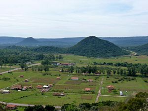
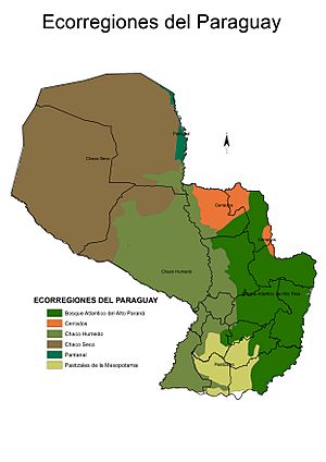
Paraguay has six main natural areas called ecoregions. These include forests, savannas, and wetlands. They are divided into two main natural regions by the Paraguay River:
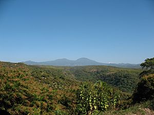
- The Paraneña region: This area has a mix of plateaus, rolling hills, and valleys.
- The Chaco region: This is a huge flat plain.
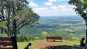
Most of Paraguay's people (about 95%) live in the Paraneña region. This area has more mountains and hills. It also has a more predictable climate. The Paraneña region has highlands in the east. These highlands slope down towards the Paraguay River. Near the river, the land becomes lower and can flood.
The Chaco region is mostly flat lowlands. It also slopes towards the Paraguay River. This area can be flooded at times and very dry at others.
The Eastern Region: Paraneña
The Eastern region stretches from the Paraguay River to the Paraná River. The Paraná River forms the border with Brazil and Argentina. Hills and mountains in the east are part of a plateau from southern Brazil. They can reach about 700 meters (2,300 feet) high.
The Eastern region also has large plains, wide valleys, and lowlands. About 80% of this region is below 300 meters (980 feet) in height. The lowest point is 60 meters (200 feet) where the Paraguay and Paraná rivers meet.
Rivers in the Eastern region mainly flow west to the Paraguay River. Some rivers flow east to the Paraná River. Low-lying meadows, which can flood, separate the eastern mountains from the Paraguay River.
This Eastern region is divided into five smaller natural areas:
- The Paraná Plateau
- The Northern Upland
- The Central Hill Belt
- The Central Lowland
- The Ñeembucú Plain
The Paraná Plateau is in the east and is heavily forested. It covers one-third of the region. Its western edge drops from about 460 meters (1,500 feet) in the north to 180 meters (590 feet) in the south.
The Northern Upland, Central Hill Belt, and Central Lowland are lower areas. They lie between the plateau and the Paraguay River. The Northern Upland is a rolling plateau. The Central Hill Belt is near Asunción and has many small, isolated peaks. The Central Lowland is a flat area that slopes gently towards the Paraguay River. Its rivers often flood, creating seasonal swamps.
The Ñeembucú Plain is in the southwest. This flat, swampy area is cut by the Tebicuary River.
The main mountain ranges in the Paraneña region are:
- The Cordillera de Amambay: This range runs along the Brazilian border in the northeast. It averages 400 meters (1,300 feet) high, with the highest point reaching 700 meters (2,300 feet).
- The Cordillera de Mbaracayú: This range connects with the Cordillera de Amambay and extends east to the Paraná River. Its average height is 200 meters (660 feet).
- The Cordillera de Caaguazú: This range extends south from where the other two meet. It averages 400 meters (1,300 feet) high. Its highest point is Cerro de San Joaquín, at 500 meters (1,600 feet).
- The Serranía de Mbaracayú: This smaller range also starts where the Amambay and Mbaracayú ranges meet. It averages 500 meters (1,600 feet) high.
The Eastern region is home to about 7.2 million people. It covers an area of 159,827 square kilometers (61,710 square miles).
The Western Region: Chaco
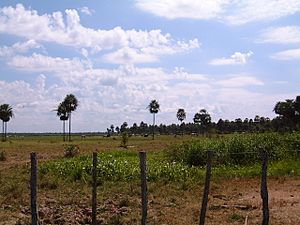
The Chaco region is separated from the Eastern region by the Paraguay River. It is a huge flat plain. Its highest points are no more than 300 meters (980 feet) high. The average height is 125 meters (410 feet). The Chaco covers over 60% of Paraguay's total land area. It slopes gently east towards the Paraguay River.
The Paraguayan Chaco has two parts:
- The Alto Chaco (Upper Chaco) or Chaco Seco (Dry Chaco): This is the western three-quarters of the region, bordering Bolivia.
- The Bajo Chaco (Lower Chaco) or Chaco Húmedo (Humid Chaco): This part borders the Paraguay River.
The western two-thirds of the Chaco have a semi-arid tropical climate. This means they get between 550 and 1,000 mm (22 to 39 inches) of rain each year. The plants here are dry, low bushes in the west. Towards the east, there are taller, thorny forests.
The eastern third of the Chaco has a semi-humid tropical climate. It gets between 1,000 and 1,300 mm (39 to 51 inches) of rain each year. The plants are taller, with tropical semi-humid forests. Along the Paraguay River, there is a different type of plant life. This area has evergreen wetlands and palm tree forests.
The dry season lasts from May to October. The wet season is from November to April. During the wet season, the plants become green and plentiful.
The soils in the Chaco are very deep and rich in nutrients. They are generally good for farming and raising animals. However, there is not much fresh groundwater in most of the Chaco. The lowlands near the Paraguay River can flood seasonally.
The Western region has about 220,805 people. It covers 246,925 square kilometers (95,340 square miles). The population density is very low here.
Rivers and Waterways
The name Paraguay can mean "Paradise of Waters." This is because there is a lot of water in and under the country. The Guarani Aquifer is a huge underground water source.
The Paraguay River is 2,600 km (1,600 miles) long. About 2,300 km (1,400 miles) of it can be used by boats. And 1,200 km (750 miles) of it either borders or flows through Paraguay. Big boats can usually reach Concepción. Medium-sized ocean ships can sometimes reach Asunción. But the river's twists and changing sandbars can make this hard.
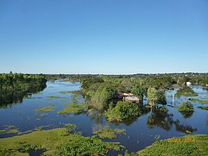
The river sometimes overflows its banks. This creates temporary swamps and floods villages. River islands and U-shaped lakes show how often the river changes its path.
Major rivers flowing into the Paraguay River from the Paraneña region include the Apa, Aquidabán, and Tebicuary Rivers. These rivers flow quickly from their sources. Then they become wider and slower as they twist westward. They can flood nearby lowlands after heavy rains.
The Paraná River is the second major river in Paraguay. It is about 4,700 km (2,900 miles) long. It enters Paraguay at Salto del Guairá (where the famous Guaíra Falls used to be). It flows 800 km (500 miles) to meet the Paraguay River. Then it continues south to the Río de la Plata in Argentina.
Large ships can usually navigate the Paraná River up to Encarnación. Smaller boats can go a bit further north. In summer, the river is deep enough for some vessels to reach Salto del Guairá. However, seasonal changes can make navigation difficult.
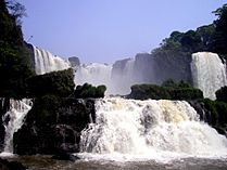
The rivers flowing east from the Paraneña region into the Paraná River are shorter and faster. An exception is the Iguazu River at the Iguazu Falls.
Paraguay's third largest river is the Pilcomayo River. It flows into the Paraguay River near Asunción. It also marks the entire border between the Chaco region and Argentina. This river is often slow and marshy. When it overflows, it feeds the Patiño Estuary.
The Chaco region generally has poor drainage. This is because the land is very flat. The water table is often just a meter (3 feet) below the surface. There are many small ponds and seasonal marshes. Much of the water in the Chaco is too salty to drink or use for farming.
The lowlands of the Paraneña region also have poor drainage. This is especially true in the Ñeembucú Plain. About 30% of the Paraneña region floods from time to time. This creates large areas of seasonal wetlands.
Paraguay's Climate
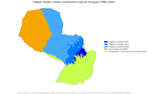
Paraguay has two main climates. The Paraneña region has a humid subtropical climate. The Chaco region has a tropical wet-and-dry climate.
The Paraneña region gets a lot of rain all year. Temperatures change moderately between seasons. In the Southern Hemisphere's summer (which is winter in the north), warm winds blow from the northeast. In winter, cold winds called pampero blow from the South Atlantic. These winds cause quick and sudden changes in the weather. Strong winds are common.
The Paraneña region has two main seasons:
- Summer: October to March
- Winter: May to August
April and September are in-between months. Temperatures are lower than in summer, and it can sometimes freeze. There isn't really a true autumn or spring.
During the mild winters, July is the coldest month. The average temperature in Asunción is about 18°C (64°F). It can freeze between 3 and 16 days a year. Some winters are very mild. But during a cold winter, very cold air from Antarctica can bring freezing temperatures to all areas. Snow has even been reported in some places.
Warm, moist air keeps the Paraneña region warm from October to March. In Asunción, the average summer temperature is about 24°C (75°F). January is the warmest month, averaging 29°C (84°F). Daytime temperatures can often reach 38°C (100°F).
Rainfall in the Paraneña region is spread fairly evenly throughout the year. The least rain falls in August. The most rain falls from March to May and from October to November. The average yearly rainfall is 1,270 mm (50 inches).
In contrast, the Chaco region has a tropical wet-and-dry climate. It is almost semi-arid. The Chaco experiences seasons that are either very wet or very dry. Temperatures are usually high, even in winter. Rainfall is light, from 500 to 1,000 mm (20 to 39 inches) per year. Most rain falls in the summer months. Large areas that are dry deserts in winter become swamps in summer.
Climate Examples
| Climate data for Asunción (1971–2000) | |||||||||||||
|---|---|---|---|---|---|---|---|---|---|---|---|---|---|
| Month | Jan | Feb | Mar | Apr | May | Jun | Jul | Aug | Sep | Oct | Nov | Dec | Year |
| Record high °C (°F) | 42.0 (107.6) |
39.6 (103.3) |
40.0 (104.0) |
37 (99) |
35 (95) |
33.0 (91.4) |
33.4 (92.1) |
39.2 (102.6) |
42.2 (108.0) |
42.8 (109.0) |
40.2 (104.4) |
41.7 (107.1) |
42.8 (109.0) |
| Mean daily maximum °C (°F) | 33.5 (92.3) |
32.6 (90.7) |
31.6 (88.9) |
28.4 (83.1) |
25.0 (77.0) |
23.1 (73.6) |
23.2 (73.8) |
24.8 (76.6) |
26.4 (79.5) |
29.2 (84.6) |
30.7 (87.3) |
32.3 (90.1) |
28.3 (82.9) |
| Daily mean °C (°F) | 27.5 (81.5) |
26.9 (80.4) |
25.9 (78.6) |
22.8 (73.0) |
19.8 (67.6) |
17.9 (64.2) |
17.6 (63.7) |
18.6 (65.5) |
20.5 (68.9) |
23.2 (73.8) |
24.8 (76.6) |
26.5 (79.7) |
22.7 (72.9) |
| Mean daily minimum °C (°F) | 22.8 (73.0) |
22.3 (72.1) |
21.3 (70.3) |
18.6 (65.5) |
15.7 (60.3) |
13.8 (56.8) |
13.1 (55.6) |
14.3 (57.7) |
15.9 (60.6) |
18.6 (65.5) |
20.1 (68.2) |
21.8 (71.2) |
17.9 (64.2) |
| Record low °C (°F) | 12.5 (54.5) |
12.5 (54.5) |
9.4 (48.9) |
6.8 (44.2) |
2.6 (36.7) |
−1.2 (29.8) |
−0.6 (30.9) |
0.0 (32.0) |
3.6 (38.5) |
7.0 (44.6) |
8.8 (47.8) |
10.0 (50.0) |
−1.2 (29.8) |
| Average rainfall mm (inches) | 147.2 (5.80) |
129.2 (5.09) |
117.9 (4.64) |
166.0 (6.54) |
113.3 (4.46) |
82.4 (3.24) |
39.4 (1.55) |
72.6 (2.86) |
87.7 (3.45) |
130.8 (5.15) |
164.4 (6.47) |
150.3 (5.92) |
1,401.2 (55.17) |
| Average precipitation days (≥ 1.0 mm) | 8 | 7 | 7 | 8 | 7 | 7 | 4 | 5 | 6 | 8 | 8 | 8 | 83 |
| Average relative humidity (%) | 68 | 71 | 72 | 75 | 76 | 76 | 70 | 70 | 66 | 67 | 67 | 68 | 70 |
| Mean monthly sunshine hours | 276 | 246 | 254 | 228 | 205 | 165 | 195 | 223 | 204 | 242 | 270 | 295 | 2,803 |
| Source 1: World Meteorological Organization | |||||||||||||
| Source 2: NOAA updated to 9/2012., Danish Meteorological Institute (sun only) | |||||||||||||
| Climate data for Ciudad del Este | |||||||||||||
|---|---|---|---|---|---|---|---|---|---|---|---|---|---|
| Month | Jan | Feb | Mar | Apr | May | Jun | Jul | Aug | Sep | Oct | Nov | Dec | Year |
| Record high °C (°F) | 38.0 (100.4) |
38.8 (101.8) |
38.0 (100.4) |
35.0 (95.0) |
32.5 (90.5) |
31.2 (88.2) |
33.0 (91.4) |
33.4 (92.1) |
35.6 (96.1) |
37.0 (98.6) |
39.6 (103.3) |
40.6 (105.1) |
40.6 (105.1) |
| Mean daily maximum °C (°F) | 31.7 (89.1) |
31.6 (88.9) |
30.8 (87.4) |
27.5 (81.5) |
24.6 (76.3) |
22.2 (72.0) |
23.0 (73.4) |
24.2 (75.6) |
25.8 (78.4) |
28.4 (83.1) |
30.1 (86.2) |
31.2 (88.2) |
27.6 (81.7) |
| Daily mean °C (°F) | 26.1 (79.0) |
25.8 (78.4) |
24.7 (76.5) |
21.5 (70.7) |
18.4 (65.1) |
16.3 (61.3) |
16.4 (61.5) |
17.6 (63.7) |
19.3 (66.7) |
22.1 (71.8) |
24.1 (75.4) |
25.6 (78.1) |
21.5 (70.7) |
| Mean daily minimum °C (°F) | 21.1 (70.0) |
21.3 (70.3) |
20.1 (68.2) |
17.2 (63.0) |
13.6 (56.5) |
11.4 (52.5) |
11.3 (52.3) |
12.3 (54.1) |
13.8 (56.8) |
16.6 (61.9) |
18.3 (64.9) |
20.1 (68.2) |
16.4 (61.5) |
| Record low °C (°F) | 10.5 (50.9) |
11.6 (52.9) |
7.5 (45.5) |
4.6 (40.3) |
−0.2 (31.6) |
0.0 (32.0) |
−3.0 (26.6) |
−1.0 (30.2) |
0.8 (33.4) |
4.0 (39.2) |
6.4 (43.5) |
8.2 (46.8) |
−3.0 (26.6) |
| Average precipitation mm (inches) | 184.1 (7.25) |
154.2 (6.07) |
136.1 (5.36) |
140.7 (5.54) |
132.3 (5.21) |
131.9 (5.19) |
90.6 (3.57) |
115.0 (4.53) |
130.2 (5.13) |
176.0 (6.93) |
163.5 (6.44) |
139.9 (5.51) |
1,694.5 (66.71) |
| Average precipitation days (≥ 0.1 mm) | 10 | 9 | 8 | 7 | 8 | 8 | 7 | 8 | 9 | 10 | 9 | 9 | 101 |
| Average relative humidity (%) | 75 | 77 | 77 | 80 | 83 | 84 | 79 | 77 | 75 | 74 | 72 | 72 | 77 |
| Source: NOAA | |||||||||||||
| Climate data for Encarnación (1961–1990) | |||||||||||||
|---|---|---|---|---|---|---|---|---|---|---|---|---|---|
| Month | Jan | Feb | Mar | Apr | May | Jun | Jul | Aug | Sep | Oct | Nov | Dec | Year |
| Record high °C (°F) | 40.5 (104.9) |
39.4 (102.9) |
39.3 (102.7) |
35.4 (95.7) |
34.0 (93.2) |
31.6 (88.9) |
32.4 (90.3) |
34.8 (94.6) |
36.6 (97.9) |
38.0 (100.4) |
40.4 (104.7) |
42.0 (107.6) |
42.0 (107.6) |
| Mean daily maximum °C (°F) | 31.2 (88.2) |
30.6 (87.1) |
29.2 (84.6) |
25.9 (78.6) |
23.2 (73.8) |
20.9 (69.6) |
21.4 (70.5) |
22.5 (72.5) |
23.9 (75.0) |
26.5 (79.7) |
28.4 (83.1) |
30.5 (86.9) |
26.2 (79.2) |
| Daily mean °C (°F) | 25.5 (77.9) |
24.9 (76.8) |
23.4 (74.1) |
20.0 (68.0) |
17.3 (63.1) |
15.2 (59.4) |
15.5 (59.9) |
16.6 (61.9) |
18.1 (64.6) |
20.6 (69.1) |
22.7 (72.9) |
24.8 (76.6) |
20.4 (68.7) |
| Mean daily minimum °C (°F) | 19.4 (66.9) |
19.5 (67.1) |
17.9 (64.2) |
14.3 (57.7) |
11.7 (53.1) |
9.9 (49.8) |
10.2 (50.4) |
10.8 (51.4) |
12.3 (54.1) |
14.3 (57.7) |
16.3 (61.3) |
18.3 (64.9) |
14.6 (58.3) |
| Record low °C (°F) | 9.3 (48.7) |
7.0 (44.6) |
5.4 (41.7) |
2.4 (36.3) |
−1.7 (28.9) |
−3.8 (25.2) |
−3.8 (25.2) |
−2.8 (27.0) |
−0.6 (30.9) |
1.6 (34.9) |
4.8 (40.6) |
7.0 (44.6) |
−3.8 (25.2) |
| Average precipitation mm (inches) | 152.2 (5.99) |
160.6 (6.32) |
142.4 (5.61) |
162.2 (6.39) |
144.2 (5.68) |
135.8 (5.35) |
102.7 (4.04) |
116.9 (4.60) |
149.5 (5.89) |
181.7 (7.15) |
161.5 (6.36) |
150.0 (5.91) |
1,759.7 (69.28) |
| Average precipitation days (≥ 0.1 mm) | 9 | 8 | 7 | 8 | 7 | 8 | 8 | 8 | 9 | 9 | 9 | 9 | 98 |
| Average relative humidity (%) | 69 | 74 | 75 | 77 | 79 | 78 | 76 | 74 | 72 | 70 | 69 | 67 | 73 |
| Mean monthly sunshine hours | 254.2 | 220.4 | 220.1 | 171.0 | 179.8 | 159.0 | 189.1 | 182.9 | 153.0 | 201.5 | 252.0 | 269.7 | 2,452.7 |
| Mean daily sunshine hours | 8.2 | 7.8 | 7.1 | 5.7 | 5.8 | 5.3 | 6.1 | 5.9 | 5.1 | 6.5 | 8.4 | 8.7 | 6.7 |
| Source 1: NOAA | |||||||||||||
| Source 2: Deutscher Wetterdienst (sun, 1988–1996) | |||||||||||||
| Climate data for Concepción (1961–1990, extremes 1937–present) | |||||||||||||
|---|---|---|---|---|---|---|---|---|---|---|---|---|---|
| Month | Jan | Feb | Mar | Apr | May | Jun | Jul | Aug | Sep | Oct | Nov | Dec | Year |
| Record high °C (°F) | 43.0 (109.4) |
41.0 (105.8) |
40.0 (104.0) |
38.2 (100.8) |
35.0 (95.0) |
34.8 (94.6) |
36.2 (97.2) |
38.4 (101.1) |
40.8 (105.4) |
41.8 (107.2) |
42.6 (108.7) |
41.4 (106.5) |
43.0 (109.4) |
| Mean daily maximum °C (°F) | 33.4 (92.1) |
33.2 (91.8) |
32.2 (90.0) |
29.3 (84.7) |
26.6 (79.9) |
24.3 (75.7) |
25.1 (77.2) |
26.5 (79.7) |
27.8 (82.0) |
30.7 (87.3) |
32.0 (89.6) |
32.6 (90.7) |
29.5 (85.1) |
| Daily mean °C (°F) | 27.6 (81.7) |
27.3 (81.1) |
26.2 (79.2) |
23.5 (74.3) |
20.3 (68.5) |
18.5 (65.3) |
18.7 (65.7) |
20.0 (68.0) |
21.8 (71.2) |
24.5 (76.1) |
26.0 (78.8) |
27.2 (81.0) |
23.5 (74.3) |
| Mean daily minimum °C (°F) | 22.7 (72.9) |
22.5 (72.5) |
21.3 (70.3) |
18.5 (65.3) |
15.9 (60.6) |
13.8 (56.8) |
13.3 (55.9) |
14.3 (57.7) |
16.1 (61.0) |
18.6 (65.5) |
20.2 (68.4) |
21.7 (71.1) |
18.2 (64.8) |
| Record low °C (°F) | 12.5 (54.5) |
12.0 (53.6) |
8.0 (46.4) |
5.3 (41.5) |
2.5 (36.5) |
0.0 (32.0) |
−1.5 (29.3) |
−3.0 (26.6) |
1.8 (35.2) |
5.7 (42.3) |
10.0 (50.0) |
11.4 (52.5) |
−3.0 (26.6) |
| Average precipitation mm (inches) | 152.8 (6.02) |
122.8 (4.83) |
140.1 (5.52) |
122.9 (4.84) |
124.8 (4.91) |
62.3 (2.45) |
42.6 (1.68) |
55.8 (2.20) |
67.7 (2.67) |
124.7 (4.91) |
161.8 (6.37) |
163.5 (6.44) |
1,341.8 (52.83) |
| Average precipitation days (≥ 0.1 mm) | 10 | 9 | 8 | 7 | 7 | 7 | 5 | 6 | 7 | 8 | 8 | 10 | 92 |
| Average relative humidity (%) | 69 | 73 | 74 | 76 | 77 | 77 | 72 | 70 | 68 | 67 | 67 | 70 | 72 |
| Mean monthly sunshine hours | 224 | 213 | 217 | 184 | 182 | 152 | 183 | 156 | 173 | 208 | 222 | 222 | 2,336 |
| Source 1: NOAA (July, November, and December record highs, and March, April, May, August, and October record lows), Meteo Climat (record highs and lows) | |||||||||||||
| Source 2: Deutscher Wetterdienst (sun) | |||||||||||||
| Climate data for Pilar | |||||||||||||
|---|---|---|---|---|---|---|---|---|---|---|---|---|---|
| Month | Jan | Feb | Mar | Apr | May | Jun | Jul | Aug | Sep | Oct | Nov | Dec | Year |
| Record high °C (°F) | 42.4 (108.3) |
40.5 (104.9) |
39.6 (103.3) |
36.5 (97.7) |
33.7 (92.7) |
31.8 (89.2) |
33.2 (91.8) |
34.9 (94.8) |
38.0 (100.4) |
39.6 (103.3) |
40.4 (104.7) |
41.6 (106.9) |
42.4 (108.3) |
| Mean daily maximum °C (°F) | 33.1 (91.6) |
32.3 (90.1) |
30.6 (87.1) |
27.0 (80.6) |
24.2 (75.6) |
21.5 (70.7) |
21.7 (71.1) |
23.0 (73.4) |
24.9 (76.8) |
28.1 (82.6) |
29.9 (85.8) |
32.2 (90.0) |
27.4 (81.3) |
| Daily mean °C (°F) | 27.6 (81.7) |
26.9 (80.4) |
25.3 (77.5) |
22.0 (71.6) |
19.2 (66.6) |
16.4 (61.5) |
16.5 (61.7) |
17.5 (63.5) |
19.4 (66.9) |
22.5 (72.5) |
24.7 (76.5) |
26.8 (80.2) |
22.1 (71.8) |
| Mean daily minimum °C (°F) | 22.4 (72.3) |
22.1 (71.8) |
20.7 (69.3) |
17.4 (63.3) |
14.9 (58.8) |
12.1 (53.8) |
12.0 (53.6) |
12.6 (54.7) |
14.3 (57.7) |
17.2 (63.0) |
19.3 (66.7) |
21.3 (70.3) |
17.2 (63.0) |
| Record low °C (°F) | 14.5 (58.1) |
12.1 (53.8) |
8.5 (47.3) |
7.7 (45.9) |
4.0 (39.2) |
1.0 (33.8) |
0.7 (33.3) |
1.0 (33.8) |
3.6 (38.5) |
7.4 (45.3) |
9.8 (49.6) |
9.8 (49.6) |
0.7 (33.3) |
| Average precipitation mm (inches) | 168.9 (6.65) |
141.5 (5.57) |
161.0 (6.34) |
178.5 (7.03) |
95.3 (3.75) |
61.8 (2.43) |
57.9 (2.28) |
47.1 (1.85) |
82.9 (3.26) |
135.2 (5.32) |
157.2 (6.19) |
125.7 (4.95) |
1,413 (55.63) |
| Average precipitation days (≥ 0.1 mm) | 9 | 8 | 9 | 8 | 6 | 6 | 5 | 6 | 7 | 9 | 9 | 8 | 90 |
| Average relative humidity (%) | 69 | 72 | 75 | 78 | 79 | 79 | 76 | 74 | 71 | 69 | 69 | 67 | 73 |
| Source: NOAA | |||||||||||||
Environment in Paraguay
Environmental issues in Paraguay Paraguay faces some environmental challenges. One big issue is deforestation. This means forests are being cut down. Between 1958 and 1985, Paraguay lost about 20,000 square kilometers (7,700 square miles) of forest.
Another concern is water pollution. Not having good ways to get rid of waste can make water unsafe. This creates health risks for many people living in cities.
Paraguay is part of several international agreements to protect the environment. These include:
- The United Nations Framework Convention on Climate Change (about global warming)
- The Climate Change-Kyoto Protocol (another climate agreement)
- The Law of the Sea (about oceans)
- The Ozone Layer Protection (about protecting Earth's ozone layer)
Paraguay has also signed, but not fully approved, the Nuclear Test Ban.
Paraguay Facts and Figures
Geographic location: 23°00′S 58°00′W
Area:
- Total: 406,750 square kilometers (157,050 square miles)
- Land: 397,300 square kilometers (153,400 square miles)
- Water: 9,450 square kilometers (3,650 square miles)
Land borders:
- Total length: 3,920 km (2,440 miles)
- Border countries:
* Argentina: 1,880 km (1,170 miles) * Bolivia: 750 km (470 miles) * Brazil: 1,290 km (800 miles)
Coastline: 0 km (Paraguay is a landlocked country, meaning it has no coast).
Highest and lowest points:
- Lowest point: Where the Rio Paraguay and Rio Paraná meet, at 46 meters (151 feet) above sea level.
- Highest point: Cerro Peró, at 842 meters (2,762 feet) above sea level.
Land use (1993 estimate):
- Farmable land: 6%
- Permanent crops: 0%
- Permanent pastures: 55%
- Forests and woodland: 32%
- Other: 7%
Irrigated land: 670 square kilometers (260 square miles) (1993 estimate).
Extreme Points of Paraguay
This is a list of the farthest points in Paraguay:
- Northernmost point: The Hito VII Fortin Coronel Sanchez pillar on the border with Bolivia, in Alto Paraguay Department.
- Easternmost point: An unnamed piece of land in the Itaipu reservoir near the town of Álvar Núñez Cabeza de Vaca, in Canindeyú Department.
- Southernmost point (including islands): An unnamed island south of Isla Talavera in the Rio Paraná, in Itapúa Department.
- Southernmost point (mainland only): An unnamed piece of land southeast of Cambyretá, just north of Candelaria, Argentina, in Itapúa Department.
- Westernmost point: The Hito I Esmeralda pillar on the border with Argentina, in Boquerón department.
- Highest point: Cerro Tres Kandú, in Guairá Department, at 842 meters (2,762 feet).
- Lowest point: The meeting point of the Rio Paraguay and Rio Parana, at 46 meters (151 feet).
- Geographic center: 133 km (83 miles) west of Concepción.
See also
 In Spanish: Geografía de Paraguay para niños
 | Sharif Bey |
 | Hale Woodruff |
 | Richmond Barthé |
 | Purvis Young |


