Guernsey County, Ohio facts for kids
Quick facts for kids
Guernsey County
|
|||
|---|---|---|---|

|
|||
|
|||

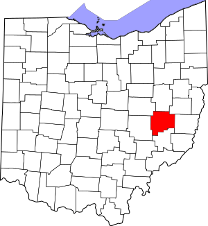
Location within the U.S. state of Ohio
|
|||
 Ohio's location within the U.S. |
|||
| Country | |||
| State | |||
| Founded | January 31, 1810 | ||
| Named for | Isle of Guernsey | ||
| Seat | Cambridge | ||
| Largest city | Cambridge | ||
| Area | |||
| • Total | 528 sq mi (1,370 km2) | ||
| • Land | 522 sq mi (1,350 km2) | ||
| • Water | 6.0 sq mi (16 km2) 1.1%% | ||
| Population
(2020)
|
|||
| • Total | 38,438 |
||
| • Density | 73/sq mi (28/km2) | ||
| Time zone | UTC−5 (Eastern) | ||
| • Summer (DST) | UTC−4 (EDT) | ||
| Congressional district | 12th | ||
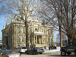
Guernsey County is a county in the east-central part of Ohio, a state in the United States. In 2020, about 38,438 people lived there.
The main city and where the county government is located is Cambridge. The county is named after the Isle of Guernsey. This is an island in the English Channel. Many of the first people who settled in Guernsey County came from that island.
Contents
History of Guernsey County
Guernsey County is in the Appalachian foothills. It was officially started on March 10, 1810. The Ohio government created it from parts of Muskingum and Belmont counties.
The first leaders of the county started their jobs on April 23, 1810. Over time, the county's borders changed. It reached its current size in 1851. This happened after some areas like Buffalo and Beaver townships became part of Noble County.
There was a disagreement about where the county seat should be. People debated between Cambridge and Washington. Cambridge was chosen because two people offered to donate land and build public buildings there.
Geography of Guernsey County
Guernsey County covers a total area of 528 square miles. Most of this area, 522 square miles, is land. The remaining 6.0 square miles, which is about 1.1%, is water.
Counties Nearby
Guernsey County shares its borders with several other counties:
- Tuscarawas County (to the north)
- Coshocton County (to the northwest)
- Harrison County (to the northeast)
- Noble County (to the south)
- Muskingum County (to the west)
- Belmont County (to the east)
Population of Guernsey County
| Historical population | |||
|---|---|---|---|
| Census | Pop. | %± | |
| 1810 | 3,051 | — | |
| 1820 | 9,292 | 204.6% | |
| 1830 | 18,036 | 94.1% | |
| 1840 | 27,748 | 53.8% | |
| 1850 | 30,438 | 9.7% | |
| 1860 | 24,474 | −19.6% | |
| 1870 | 23,838 | −2.6% | |
| 1880 | 27,197 | 14.1% | |
| 1890 | 28,645 | 5.3% | |
| 1900 | 34,425 | 20.2% | |
| 1910 | 42,716 | 24.1% | |
| 1920 | 45,352 | 6.2% | |
| 1930 | 41,486 | −8.5% | |
| 1940 | 38,822 | −6.4% | |
| 1950 | 38,452 | −1.0% | |
| 1960 | 38,579 | 0.3% | |
| 1970 | 37,665 | −2.4% | |
| 1980 | 42,024 | 11.6% | |
| 1990 | 39,024 | −7.1% | |
| 2000 | 40,792 | 4.5% | |
| 2010 | 40,087 | −1.7% | |
| 2020 | 38,438 | −4.1% | |
| U.S. Decennial Census 1790-1960 1900-1990 1990-2000 2020 |
|||
What the 2010 Census Showed
In 2010, there were 40,087 people living in Guernsey County. These people lived in 16,210 households. About 10,949 of these were families.
The county had about 76.8 people per square mile. There were 19,193 housing units in total. Most people, 96.0%, were white. About 1.5% were black or African American. A small number were Asian (0.3%) or American Indian (0.2%). About 0.9% of the population was of Hispanic or Latino origin.
Many people had German (22.3%), Irish (15.2%), or English (12.4%) backgrounds. About 31.1% of households had children under 18 living with them. The average age of people in the county was 40.9 years.
Communities in Guernsey County
City
- Cambridge (This is the county seat)
Villages
div col end}}
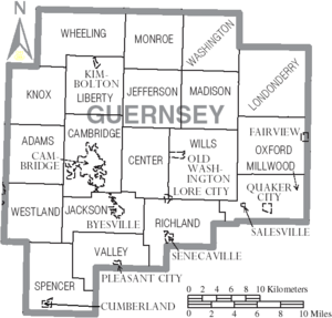
Townships
- Adams
- Cambridge
- Center
- Jackson
- Jefferson
- Knox
- Liberty
- Londonderry
- Madison
- Millwood
- Monroe
- Oxford
- Richland
- Spencer
- Valley
- Washington
- Westland
- Wheeling
- Wills
div col end}}
Census-designated places
- Buffalo
- Kimbolton
- Salesville
Unincorporated communities
Images for kids
See also
 In Spanish: Condado de Guernsey para niños


