Hastings, Minnesota facts for kids
Quick facts for kids
Hastings
|
|
|---|---|
Aerial view of Hastings
|
|
|
|
| Country | United States |
| State | Minnesota |
| Counties | Dakota, Washington |
| Founded | 1853 |
| Incorporated | March 7, 1857 |
| Area | |
| • City | 11.20 sq mi (29.02 km2) |
| • Land | 10.35 sq mi (26.81 km2) |
| • Water | 0.85 sq mi (2.20 km2) |
| Elevation | 801 ft (244 m) |
| Population
(2020)
|
|
| • City | 22,154 |
| • Estimate
(2022)
|
21,712 |
| • Density | 2,139.86/sq mi (826.20/km2) |
| • Metro | 3,693,729 |
| Time zone | UTC–6 (Central (CST)) |
| • Summer (DST) | UTC–5 (CDT) |
| ZIP Code |
55033
|
| Area code(s) | 651 |
| FIPS code | 27-27530 |
| GNIS feature ID | 2394320 |
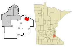
Hastings (pronounced HAY-stingz) is a city in Minnesota, United States. It is mostly located in Dakota County, where it serves as the county seat. This means it's the main center for the county's government. A smaller part of Hastings is in Washington County.
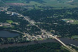
The city is found where three important rivers meet: the Mississippi, the Vermillion, and the St. Croix Rivers. In 2020, about 22,154 people lived in Hastings. The city was named after Henry Hastings Sibley, who was the very first elected governor of Minnesota.
Hastings grew because of its great location. The land was well-drained, making it easy to build on. It also had a good port for riverboats and was close to the Vermillion River falls, which could be used to create power. Other areas nearby were either too wet or too hilly for easy settlement.
Major roads like U.S. Highway 61 and Minnesota State Highways 55 and 316 are important routes in Hastings.
Contents
Discovering Hastings: A Look at Its History
In the winter of 1820, a group of soldiers from Fort Snelling came to the area where Hastings is now. They were there to protect a shipment of supplies that was blocked. Lieutenant William G. Oliver set up camp in a spot that became known as Oliver's Grove. Later, in 1833, a trading post opened there.
After the Treaty of Mendota in 1851, the land became open for white settlers. Oliver's Grove was officially mapped out and became a city in 1857. This was just one year before Minnesota became a state. In the same year, Hastings was chosen as the county seat for Dakota County. The city got its name when the original founders put suggestions into a hat and drew "Hastings."
Early Growth and Challenges
In the mid-1800s, Hastings, along with Prescott, Wisconsin, and a nearby area called Nininger, saw a lot of land speculation. This means people bought land hoping its value would go up quickly. A person named Ignatius L. Donnelly even thought the area could become a "New Chicago."
However, a financial crisis called the Panic of 1857 stopped this dream. The land speculation and the panic meant the cities didn't grow as much as expected, even though they were located where two big rivers met. Today, Nininger is mostly ruins, and the combined population of Hastings and Prescott is around 25,000.
Hastings' Historic Courthouse
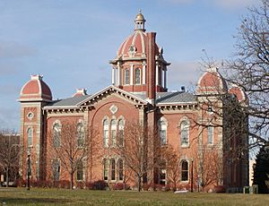
Hastings has Minnesota's second-oldest county courthouse that is still standing. It was finished in 1871 and cost $63,000 to build. The county government started moving to a new building in 1974. In 1989, the City of Hastings bought the old courthouse. It was reopened in 1993 as the City Hall.
Bridges Over the Mississippi
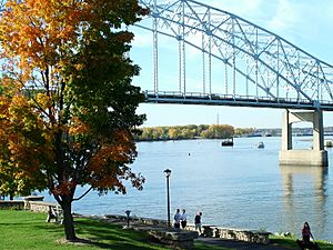
In 1895, a unique spiral bridge was built over the Mississippi River. Its design was meant to slow down horse-drawn wagons as they entered downtown. This unusual bridge became a popular tourist spot. But it was taken down in 1951 because it couldn't handle modern cars. The bridge built in 1951 was also later replaced by the Hastings High Bridge, which opened in 2013.
Lock and Dam No. 2
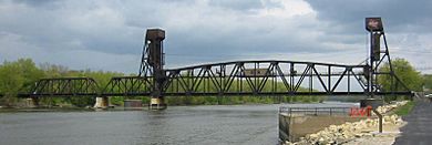
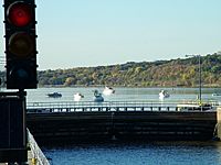
In 1930, the Army Corps of Engineers finished building Lock and Dam No. 2 in Hastings. This is part of a system of locks on the Mississippi River that helps boats travel from Minneapolis to St. Louis. Lock and Dam No. 2 is special because it's home to the first commercial, federally approved hydrokinetic power plant in the country. This project is a partnership between the City of Hastings and Hydro Green Energy.
Fasbender Clinic
The Fasbender Clinic, designed by the famous architect Frank Lloyd Wright, is an important building in the city.
Railroads Connecting Hastings
Two major Minnesota railroads were named after Hastings: the Hastings & Dakota Railway and the Stillwater & Hastings Railway.
In 1867, local leaders like William LeDuc and John Meloy, with money from investors, started the Hastings & Dakota Railway. Their big goal was to "cross the Rocky Mountains and meet the Pacific Ocean." By the 1870s, the H&D line was built from Hastings to the South Dakota border. During this time, the H&D became part of the Chicago, Milwaukee & St. Paul Railroad, also known as the Milwaukee Road. The H&D line eventually became the main route for the Milwaukee Road's expansion to Seattle in 1909.
In 1880, a new branch line, the Stillwater & Hastings, was built between Hastings and Stillwater. This line helped move wood and farm products from Stillwater to Hastings, making Hastings an important place for switching railroad cars. The Milwaukee Road took control of this line in 1882 and it was very profitable. However, the Milwaukee Road stopped using the S&H line in 1979.
Today, the Canadian Pacific Railway operates the old Milwaukee main line through Hastings. Some parts of the old H&D line are now used for bicycle paths.
Geography and Natural Beauty
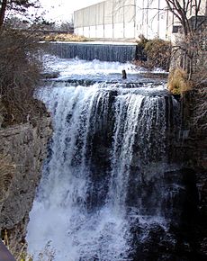
Hastings covers about 11.18 square miles (29.02 square kilometers). Most of this is land, with about 0.94 square miles (2.20 square kilometers) being water. The Mississippi River forms most of Hastings' northern border. The Vermillion River flows through the southern part of the city. It goes over a beautiful falls right next to a large ConAgra grain elevator.
Along the northern shore of the Mississippi, you can see bluffs (steep cliffs). There's also a gorge around the Vermillion River below the falls. Hastings is home to two small lakes, Lake Rebecca and Lake Isabel, both of which drain into the Mississippi River. A marshy area in the northeast, which is a flood plain for the Mississippi and Vermillion Rivers, is sometimes called "Cow Town."
Hastings is located on the Mississippi side of where it meets the St. Croix River. This means Prescott, Wisconsin is across the Mississippi River from Hastings.
Weather in Hastings
| Climate data for Lock and Dam No. 2 (1991–2020 normals, extremes 1893–present) | |||||||||||||
|---|---|---|---|---|---|---|---|---|---|---|---|---|---|
| Month | Jan | Feb | Mar | Apr | May | Jun | Jul | Aug | Sep | Oct | Nov | Dec | Year |
| Record high °F (°C) | 54 (12) |
62 (17) |
80 (27) |
91 (33) |
96 (36) |
100 (38) |
101 (38) |
97 (36) |
94 (34) |
92 (33) |
78 (26) |
68 (20) |
101 (38) |
| Mean daily maximum °F (°C) | 24.1 (−4.4) |
29.0 (−1.7) |
41.1 (5.1) |
56.4 (13.6) |
68.6 (20.3) |
78.8 (26.0) |
83.0 (28.3) |
80.9 (27.2) |
73.4 (23.0) |
59.4 (15.2) |
43.0 (6.1) |
29.7 (−1.3) |
55.6 (13.1) |
| Daily mean °F (°C) | 14.9 (−9.5) |
18.8 (−7.3) |
31.4 (−0.3) |
46.1 (7.8) |
58.2 (14.6) |
68.7 (20.4) |
73.1 (22.8) |
71.1 (21.7) |
63.2 (17.3) |
49.7 (9.8) |
34.8 (1.6) |
21.7 (−5.7) |
46.0 (7.8) |
| Mean daily minimum °F (°C) | 5.7 (−14.6) |
8.7 (−12.9) |
21.8 (−5.7) |
35.7 (2.1) |
47.8 (8.8) |
58.6 (14.8) |
63.3 (17.4) |
61.3 (16.3) |
53.1 (11.7) |
40.0 (4.4) |
26.6 (−3.0) |
13.7 (−10.2) |
36.4 (2.4) |
| Record low °F (°C) | −34 (−37) |
−36 (−38) |
−20 (−29) |
8 (−13) |
26 (−3) |
38 (3) |
47 (8) |
42 (6) |
32 (0) |
18 (−8) |
−8 (−22) |
−25 (−32) |
−36 (−38) |
| Average precipitation inches (mm) | 0.90 (23) |
0.91 (23) |
1.78 (45) |
3.10 (79) |
4.33 (110) |
4.94 (125) |
4.37 (111) |
4.23 (107) |
3.21 (82) |
2.61 (66) |
1.72 (44) |
1.23 (31) |
33.33 (847) |
| Average precipitation days (≥ 0.01 in) | 8.3 | 7.4 | 8.6 | 11.9 | 13.1 | 13.1 | 10.8 | 10.1 | 9.7 | 10.4 | 8.0 | 9.1 | 120.5 |
| Source: NOAA | |||||||||||||
People of Hastings: Demographics
| Historical population | |||
|---|---|---|---|
| Census | Pop. | %± | |
| 1860 | 1,653 | — | |
| 1870 | 3,458 | 109.2% | |
| 1880 | 3,809 | 10.2% | |
| 1890 | 3,705 | −2.7% | |
| 1900 | 3,811 | 2.9% | |
| 1910 | 3,983 | 4.5% | |
| 1920 | 4,571 | 14.8% | |
| 1930 | 5,086 | 11.3% | |
| 1940 | 5,662 | 11.3% | |
| 1950 | 6,560 | 15.9% | |
| 1960 | 8,965 | 36.7% | |
| 1970 | 12,195 | 36.0% | |
| 1980 | 12,827 | 5.2% | |
| 1990 | 15,445 | 20.4% | |
| 2000 | 18,204 | 17.9% | |
| 2010 | 22,172 | 21.8% | |
| 2020 | 22,154 | −0.1% | |
| 2022 (est.) | 21,712 | −2.1% | |
| U.S. Decennial Census 2020 Census |
|||
In 2010, there were 22,172 people living in Hastings. About 8,735 households and 5,802 families called the city home. The city had about 2,165 people per square mile.
Most of the people in Hastings (94.1%) were White. Other groups included African American (1.6%), Native American (0.5%), and Asian (0.9%). About 2.6% of the population was Hispanic or Latino.
In terms of households, 34.1% had children under 18 living with them. Half of the households (50.0%) were married couples. About 11.6% had a female head of household with no husband, and 4.9% had a male head of household with no wife.
The average age in Hastings was 37.5 years old. About 24.7% of residents were under 18, and 13.6% were 65 or older. The population was almost evenly split between males (49.2%) and females (50.8%).
Arts, Culture, and Fun Places to Visit
Hastings has many interesting places to explore:
- Alexis Bailly Vineyard
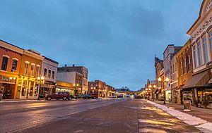
- East Second Street Commercial Historic District
- Hastings High School
- Hastings Sand Coulee Scientific and Natural Area
- LeDuc Historic Estate
- Lock and Dam No. 2
- Ramsey Mill Ruins
- Spring Lake Park Reserve
- Vermillion Falls Park
- West Second Street Residential Historic District
Education: Learning in Hastings
Hastings Public Schools manages the public schools in the city. Here's a look at some of the schools that have served Hastings over the years:
| Hastings, Minnesota Schools | |||||
|---|---|---|---|---|---|
| School Name | Grades Served | Location | Date Established | Picture | Mascot |
| Minnesota Central University | Post Secondary | 8th & Sibley Street | 1857–1867 (purchased for the Hastings Public School in 1867 and torn down in 1899) | ||
| Everett School | Primary and Intermediate | 2nd & Franklin Street | 1866–1927 | Puppy Dogs | |
| Irving School | High School | 8th & Sibley Street | 1867–1899 (Formerly Minnesota Central University, fire destroyed the building around 1899) | ||
| Hastings Central School | High School | 8th & Sibley Street | 1899–1961 | ||
| Hastings Junior-Senior High School | High School | 10th & Vermillion Street | 1961–1999 (Several additions were made and later became Hastings Middle School) | Raiders (18th Century Knight on a Horse) | |
| Tilden Elementary School | Elementary School | 3rd & River Street | ?-closed in 2009 (Building currently used as a community center) | Tigers | |
| Cooper Elementary School | Elementary School | 17th & Vermillion Street | 1959-closed in 2009 (Building currently used as a community preschool) | Comets | |
| Hiawatha Elementary School | Elementary School | 10th & Vermillion, then moved to 10th & Tyler | ?-1961 | ||
| John F. Kennedy Elementary School | Elementary School | 10th & Tyler Street | 1962-current | Cougars | |
| Pinecrest Elementary School | Elementary School | 13th & Pine Street | ?-current | Panthers | |
| Hastings Senior High School, new | High School | 11th & Pine Street | 1972-current (currently used as Hastings Middle School) | Raiders (raccoon) | |
| Christa McAulliffe Elementary School | Elementary School | 12th & Pleasant Street | 1988-current | Eagles (Challengers) | |
| Hastings Senior High School, new | High School | General Sieben Drive and Featherstone Road | 2000-current | Raiders (pirate) | |
Getting Around: Transportation in Hastings
Main Roads
![]() U.S. Highway 61 is the busiest road in Hastings. It's also known as Vermillion Street. This four-lane highway runs north-south through the eastern part of Hastings. It crosses the Mississippi River on the Hastings High Bridge to the north, heading towards Cottage Grove and Saint Paul. To the south, it goes towards Red Wing. The new four-lane bridge was completed in 2013.
U.S. Highway 61 is the busiest road in Hastings. It's also known as Vermillion Street. This four-lane highway runs north-south through the eastern part of Hastings. It crosses the Mississippi River on the Hastings High Bridge to the north, heading towards Cottage Grove and Saint Paul. To the south, it goes towards Red Wing. The new four-lane bridge was completed in 2013.
![]() Minnesota State Highway 55 is the main east-west road. This four-lane highway enters the city from the west and ends at Highway 61 in the middle of town. Highway 55 is a key route for people commuting from Hastings to places like Eagan and Minneapolis.
Minnesota State Highway 55 is the main east-west road. This four-lane highway enters the city from the west and ends at Highway 61 in the middle of town. Highway 55 is a key route for people commuting from Hastings to places like Eagan and Minneapolis.
![]() Highway 316 is a 10-mile highway that starts at Highway 61 in southern Hastings. It heads southeast towards Welch Township. This road offers a more direct shortcut between two points of Highway 61. Both Highways 316 and 61 are part of the Great River Road.
Highway 316 is a 10-mile highway that starts at Highway 61 in southern Hastings. It heads southeast towards Welch Township. This road offers a more direct shortcut between two points of Highway 61. Both Highways 316 and 61 are part of the Great River Road.
![]() Highway 291 (also called Minnesota Veterans Home Highway) is a short, one-mile road in eastern Hastings. It crosses the Vermillion River.
Highway 291 (also called Minnesota Veterans Home Highway) is a short, one-mile road in eastern Hastings. It crosses the Vermillion River.
Other important roads leading into Hastings include Dakota County Roads 42, 46, 47, and 54.
Public Transport and River Travel
Hastings does not have the Metro Transit public bus routes. However, there are plans to bring commuter trains to Hastings through the Red Rock Corridor project. While Amtrak trains pass through Hastings, they don't stop here. Passengers need to go to St. Paul or Red Wing to catch a train.
The Mississippi River is a major route for barges. These large boats are helped upstream by Lock and Dam No. 2 in northwest Hastings. There are also several places where private boats can access the Mississippi River.
Famous People from Hastings
Many notable people have connections to Hastings:
- Jackie Biskupski: Former mayor of Salt Lake City.
- Taylor Chorney: Professional hockey player.
- MaryJanice Davidson: Author.
- Gil Dobie: College football coach.
- Mark Steven Johnson: Film director and writer.
- Craig Kilborn: Comedian and television personality.
- Clara Mairs: Painter and printmaker.
- Dan Peltier: Former baseball player for the Texas Rangers.
- Terry Redlin: Painter.
- Harry Sieben: Former speaker of the Minnesota House of Representatives.
- Derek Stepan: Professional hockey player.
- Jeff Taffe: Professional hockey player.
- Dean Talafous: Former NHL hockey player.
- Ben Utecht: Professional football player and singer.
See also
 In Spanish: Hastings (Minnesota) para niños


