Haywood County, Tennessee facts for kids
Quick facts for kids
Haywood County
|
|
|---|---|

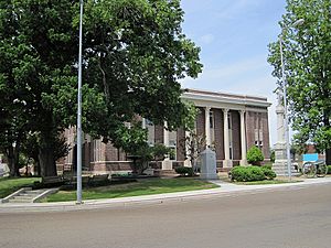
Haywood County Courthouse
|
|

Location within the U.S. state of Tennessee
|
|
 Tennessee's location within the U.S. |
|
| Country | |
| State | |
| Founded | 1823 |
| Named for | John Haywood |
| Seat | Brownsville |
| Largest city | Brownsville |
| Area | |
| • Total | 534 sq mi (1,380 km2) |
| • Land | 533 sq mi (1,380 km2) |
| • Water | 0.9 sq mi (2 km2) 0.2%% |
| Population
(2020)
|
|
| • Total | 17,864 |
| • Estimate
(2023)
|
17,328 |
| • Density | 33.45/sq mi (12.916/km2) |
| Time zone | UTC−6 (Central) |
| • Summer (DST) | UTC−5 (CDT) |
| Congressional district | 8th |
| Website | https://haywoodtn.gov/ |
Haywood County is a county in the state of Tennessee, located in West Tennessee. In 2020, about 17,864 people lived there. Its main city and county seat is Brownsville. Haywood County is one of only two counties in Tennessee where most of the people are African-American.
Contents
History of Haywood County
Haywood County was formed in 1823–1824 from a part of Madison County. It was named after John Haywood, a judge and historian from Tennessee. The state government chose Brownsville as the county seat.
Over time, Haywood County became smaller. In 1835, some land was given to help create Lauderdale County. In 1870, most of the land north of the Forked Deer River was given to the new Crockett County.
Farming and People in the Past
For a long time, farming was the main way people made a living in Haywood County. They mostly grew cotton. Before the Civil War, large farms called plantations used enslaved African-American workers to grow these crops.
After slavery ended in 1865, many farm owners hired former enslaved people as tenant farmers or sharecroppers. These workers would farm the land and share the crops with the landowner. Cotton remained a very important crop. Even today, most people in this rural county are Black.
Voting Rights and Challenges
In the past, some African-Americans in the county faced unfair treatment. After the Civil War, some people tried to stop Black citizens from voting. In 1940, Elbert Williams, an African-American man, was killed in Brownsville. He was trying to help Black people register to vote and had started a local chapter of the NAACP (National Association for the Advancement of Colored People). His body was found in the Hatchie River. He was the last person recorded to be killed in this way in Tennessee because of voting rights.
Geography and Nature
Haywood County covers about 534 square miles. Most of this area, 533 square miles, is land, and a small part, 0.9 square miles, is water.
The county is located near the southeastern edge of the New Madrid Seismic Zone. This area has a higher risk of earthquakes.
Neighboring Counties
Haywood County shares borders with several other counties:
- Crockett County (to the north)
- Madison County (to the east)
- Hardeman County (to the southeast)
- Fayette County (to the south)
- Tipton County (to the west)
- Lauderdale County (to the northwest)
Protected Natural Areas
- Hatchie National Wildlife Refuge is a special area in the county that protects wildlife and their homes.
Population Changes
Since 1940, the number of people living in Haywood County has generally gone down. After the events involving Elbert Williams in 1940, many Black Americans left the area. Also, new machines made farming easier, so fewer farm workers were needed. Many African-Americans moved away as part of the Great Migration, seeking new opportunities.
| Historical population | |||
|---|---|---|---|
| Census | Pop. | %± | |
| 1830 | 5,334 | — | |
| 1840 | 13,870 | 160.0% | |
| 1850 | 17,259 | 24.4% | |
| 1860 | 19,232 | 11.4% | |
| 1870 | 25,094 | 30.5% | |
| 1880 | 26,053 | 3.8% | |
| 1890 | 23,558 | −9.6% | |
| 1900 | 25,189 | 6.9% | |
| 1910 | 25,910 | 2.9% | |
| 1920 | 25,386 | −2.0% | |
| 1930 | 26,063 | 2.7% | |
| 1940 | 27,699 | 6.3% | |
| 1950 | 26,212 | −5.4% | |
| 1960 | 23,393 | −10.8% | |
| 1970 | 19,596 | −16.2% | |
| 1980 | 20,318 | 3.7% | |
| 1990 | 19,437 | −4.3% | |
| 2000 | 19,797 | 1.9% | |
| 2010 | 18,787 | −5.1% | |
| 2020 | 17,864 | −4.9% | |
| 2023 (est.) | 17,328 | −7.8% | |
| U.S. Decennial Census 1790–1960 1900–1990 1990–2000 2010–2014 |
|||
What the Census Shows
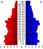
The 2020 United States census counted 17,864 people in the county. There were 7,181 households, which are groups of people living together. About 4,727 of these were families.
In 2020, about 50.34% of the people in Haywood County were Black or African American. About 42.29% were White. Other groups made up smaller percentages. About 4.69% of the population was Hispanic or Latino.
Economy and Jobs
The biggest industry in Haywood County is agriculture, which means farming. Haywood County grows more cotton than any other county in Tennessee. In 2003, they produced 189,000 bales of cotton on 103,000 acres of land. Soybeans and corn are also important crops. In 2004, farming and related businesses added over $130 million to the county's economy. By 2017, other crops like grains and tobacco also brought in a lot of money, but cotton was still the most grown crop.
In 2009, a large area of land near Stanton was set aside for a big industrial project. This "megasite" was planned for a major factory or business. In September 2021, Ford and SK Innovation announced they would build a huge complex there called "Blue Oval City". This facility will make electric vehicles and batteries. It is expected to open in 2025 and cost about $5.6 billion. It will also create around 5,700 jobs, making it the most expensive single investment in Tennessee's history.
Communities in Haywood County
Cities and Towns
- Brownsville (This is the main city and county seat.)
- Stanton
Smaller Communities
Many smaller communities are also part of Haywood County. These include:
- Allen Station
- Asbury
- Belle Eagle
- Christmasville
- Cliff Creek
- Dancyville
- Eurekaton
- Hillville
- Jones Station
- Keeling
- Nutbush
- Rudolph
- Tabernacle
- Tibbs
- Woodland
Famous People from Haywood County
Haywood County has been home to several notable people.
- Sleepy John Estes was a famous blues guitarist, songwriter, and singer. He was born around 1899 or 1900 and lived most of his life in Brownsville. He passed away in 1977.
- Tony Delk was a professional basketball player who spent his teenage years in Brownsville. He was a first-round pick in the NBA draft.
- Hambone Willie Newbern was another blues musician from the Brownsville area.
- Singer Tina Turner grew up in Nutbush, Haywood County. Her famous song "Nutbush City Limits" is about the town.
- Elbert Williams was an important activist who worked for voting rights.
Politics and Government
Haywood County has become a county where political races can be very close. The county's population has been decreasing, similar to other rural areas in the Black Belt. For many years, Haywood County mostly supported Democratic candidates in presidential elections. However, in 2024, the Democratic candidate, Kamala Harris, won by only 25 votes against Donald Trump. This was the closest presidential election in the county since 1972.
Republicans have been gaining more support in the county recently. For example, the current county mayor, David Livingston, is a Republican. He was first elected in 2018 and re-elected in 2022. He even received support from Republican U.S. Senator Marsha Blackburn. Republican Governor Bill Lee also won the county in his 2022 re-election, and Marsha Blackburn won the county in her 2024 re-election for the U.S. Senate.
See also
 In Spanish: Condado de Haywood (Tennessee) para niños


