
Hilton Head Island, South Carolina facts for kids
Quick facts for kids
Hilton Head Island
|
||
|---|---|---|

Harbour Town Marina in Sea Pines Resort with the Harbour Town Lighthouse
|
||
|
||
| Nickname(s):
Hilton Head, HHI
|
||

Hilton Head Island
Location in South Carolina

Hilton Head Island
Location in the United States
|
||
| Country | United States | |
| State | South Carolina | |
| County | Beaufort | |
| Incorporated (town) | 1983 | |
| Named for | Navigational marker left by William Hilton | |
| Area | ||
| • Total | 69.13 sq mi (179.05 km2) | |
| • Land | 41.35 sq mi (107.10 km2) | |
| • Water | 27.78 sq mi (71.95 km2) 40.19% | |
| Elevation | 10 ft (3 m) | |
| Population
(2020)
|
||
| • Total | 37,661 | |
| • Estimate
(2023)
|
38,097 | |
| • Density | 910.72/sq mi (351.63/km2) | |
| • Urban | 71,824 (US: 395th) | |
| • Urban density | 1,135.7/sq mi (438.5/km2) | |
| • Metro | 232,523 (US: 202nd) | |
| GDP | ||
| • Metro | $12.497 billion (2022) | |
| Time zone | UTC−5 (EST) | |
| • Summer (DST) | UTC−4 (EDT) | |
| ZIP code |
29925, 29926, 29928
|
|
| Area code(s) | 843 | |
| FIPS code | 45-34045 | |
| GNIS feature ID | 1246002 | |

Hilton Head Island, often called Hilton Head, is a fun resort town and island in South Carolina. It's about 20 miles northeast of Savannah, Georgia. The island is a popular place for vacations.
About 37,661 people live there all year. But in summer, the population can grow to 150,000 visitors! Hilton Head is the main city of a larger area that has about 232,523 people.
The island got its name from Captain William Hilton Jr. In 1663, he found a piece of land near Port Royal Sound. Mapmakers then called it "Hilton's Headland." The island has a long history. Native Americans lived there thousands of years ago. Later, Europeans explored it and grew special cotton.
During the American Civil War, Hilton Head was important for the Union army. Many formerly enslaved people came to the island. Their descendants, called the Gullah, still live there today. They have kept much of their unique culture.
Hilton Head Island has 12 miles of beautiful beaches on the Atlantic Ocean. Many people visit each year, bringing lots of money to the local economy. The island also has many cultural activities. These include plays, a choir, a symphony orchestra, and a yearly wine tasting event. It also hosts the RBC Heritage, a big golf tournament.
Hilton Head Island became a town in 1983. It is known for its eco-friendly building rules. The town makes sure new buildings don't harm nature. They also protect the many trees on the island. About 70% of the island is inside private communities. But the town has many public beach spots for everyone to enjoy.
Contents
Exploring Hilton Head Island's Past
Early Discoveries and Native Americans

One of the oldest signs of human life here is the Sea Pines shell ring. It's a circle of shells about 150 feet wide. Experts believe it's over 4,000 years old! Native Americans likely lived inside the ring. They used the center as a common area. Two other shell rings were used to make roads and buildings. The Green's Shell Enclosure, Sea Pines, and Skull Creek shell rings are now protected by law.
For a long time, different European countries wanted control of the waters around Hilton Head Island. These included the English, Spanish, French, and Scots.
In 1521, a Spanish group led by Francisco Cordillo explored the area. This was the first time Europeans met the local tribes. In 1663, Captain William Hilton Jr sailed here from Barbados. He was exploring land for the King of England. He named a piece of land "Hilton's Head" after himself. He wrote about the trees, crops, and fresh air.
From the 17th to 19th Centuries


In 1698, Hilton Head Island became part of a large land grant. For a while, it was even called Trench's Island. Later, a part of it was named "John's Island."
Around the 1740s, a ship called the Beaufort was placed near Hilton Head. It guarded against attacks from the Spanish in St. Augustine, Florida. Captain David Cutler Braddock commanded the Beaufort. He was a famous sailor and privateer (a private ship allowed to attack enemy ships).
During the American Revolution, only a few farmers lived on Hilton Head. They supported the King of England. After the war, they stayed and lived under the new government. In 1788, a small church called Zion Chapel of Ease was built. Its old cemetery is still there. It holds the oldest building on the island, the Baynard Mausoleum, built in 1846.
In 1790, William Elliott II grew the first crop of Sea Island Cotton on Hilton Head. This was a very important crop for the South.
During the American Civil War, Fort Walker was a fort for the Confederate army. It protected the entrance to Port Royal Sound. On November 7, 1861, over 12,000 Union troops attacked it. The fort fell and was renamed Fort Welles.
Hilton Head Island became a key base for the Union army. They used it to block Southern ports like Savannah and Charleston. The Union also built a large military hospital here.
Hundreds of formerly enslaved people came to Hilton Head. They could buy land, go to school, and live in special housing. A community called Mitchelville was built for them. It was named after General Ormsby M. Mitchel.
In 1865, Major General Quincy Adams Gillmore declared that "people of the black race are free citizens." He said their rights must be respected. Martin Delany, the only black officer to become a major in the Civil War, was also stationed here.
The Leamington Lighthouse was built in the 1870s. In 1890, a rich shipping businessman, William P. Clyde, bought 9,000 acres for a hunting area.
In 1893, a huge hurricane hit the Sea Islands. It caused a 16-foot storm surge and killed over 1,000 people.
20th and 21st Centuries: Modern Development


Around 1900, an experimental steam cannon was built to guard Port Royal Sound. In 1931, Alfred Lee Loomis and Landon K. Thorne bought 17,000 acres on the island. They used it as a private game reserve. During World War II, large concrete gun platforms were built on the coast. These defended against possible attacks. The U.S. Coast Guard also trained beach patrol personnel with horses and dogs here.
In the early 1950s, logging was a big industry. Only about 300 people lived on the island. Before 1956, you could only get to Hilton Head by private boat or ferry.
The James F. Byrnes Bridge was built in 1956. This bridge cost $1.5 million and allowed cars to reach the island. In 1974, a barge hit the bridge. The Army Corps of Engineers built a temporary bridge while it was fixed. A new, larger bridge replaced it in 1982.
Hilton Head became a resort in 1956 when Charles E. Fraser started Sea Pines Resort. Other developments followed, like Hilton Head Plantation. Sea Pines became famous for Harbour Town and its lighthouse. Fraser was an environmentalist. He even changed the marina's design to save an old live oak tree. This tree became known as the Liberty Oak. Singer Gregg Russell performed under it for over 25 years. Fraser was buried next to the tree when he passed away in 2002.
The Heritage Golf Classic started in Sea Pines Resort in 1969. It's still a regular stop on the PGA Tour. Also in 1969, local groups stopped a chemical plant from being built. These events helped the community come together. The Chamber of Commerce then pushed for the island to become an official town. In May 1983, Hilton Head Island officially became a town.
The Land Management Ordinance was passed in 1987. This law helps protect the island's natural beauty. Disney's Hilton Head Island Resort opened in 1996. The Cross Island Parkway opened in 1997. In 2007, smoking was banned indoors in public places. Shelter Cove Towne Centre opened in 2014.
Many historic places on Hilton Head Island are listed on the National Register of Historic Places. These include Fort Howell, Fort Mitchel, and the Zion Cemetery.
Island Geography
Land and Water Features
Hilton Head Island is shaped like a shoe. It's about 20 miles northeast of Savannah, Georgia. It's also about 90 miles south of Charleston.
The town covers about 69.13 square miles. About 41.35 square miles is land, and 27.78 square miles (40.19%) is water.
What is a Barrier Island?

Hilton Head Island is sometimes called the second largest barrier island on the East Coast. A barrier island is a long, narrow island that protects the mainland from ocean storms. The north part of Hilton Head is an older "sea island." The south part is a newer barrier island. Broad Creek, a tidal marsh, separates these two parts.
Barrier islands have sandy beaches, ocean waves, and shifting sands. Behind the beach, there are grassy dunes. Further inland, you find forests with wetlands. On the side facing the mainland, there are salt or tidal marshes.
Amazing Wildlife
Hilton Head Island is home to many animals. You can find alligators, deer, loggerhead sea turtles, manatees, and dolphins. Hundreds of bird species also live here.
From May to October, groups patrol the beaches to protect sea turtles. They check nesting spots and move nests if needed. During summer, you can join a "Turtle Talk & Walk" tour. This teaches you about these endangered animals. To protect the turtles, lights on the beach must be off or shielded at night.
The waters around Hilton Head are special. Dolphins here use a unique hunting method called "strand feeding." They herd fish onto mud banks. Then, the dolphins lie on their side to eat before sliding back into the water.
Stingrays are also common in the ocean waters. They often hide in the shallow sand near the shore. Stingrays usually avoid people. But if you step on one by accident, it might sting you with its poisonous barb. These stings are very painful but usually not life-threatening.
The saltmarsh areas around Hilton Head are important. They are where many fish and marine mammals feed, breed, and grow up. The water looks murky because it's full of tiny plants and animals called plankton. Plankton feed oysters, shrimp, and small fish like menhaden and mullet. These smaller creatures then feed larger fish and mammals. Popular fish for sport fishing here include red drum, spotted sea trout, sheepshead, cobia, tarpon, and different types of sharks.
Climate and Weather
Hilton Head Island has a humid subtropical climate. This means it has hot, humid summers and mild winters.
| Climate data for Hilton Head Island | |||||||||||||
|---|---|---|---|---|---|---|---|---|---|---|---|---|---|
| Month | Jan | Feb | Mar | Apr | May | Jun | Jul | Aug | Sep | Oct | Nov | Dec | Year |
| Mean daily maximum °F (°C) | 61 (16) |
63 (17) |
69 (21) |
71 (22) |
82 (28) |
87 (31) |
90 (32) |
88 (31) |
85 (29) |
78 (26) |
70 (21) |
63 (17) |
76 (24) |
| Mean daily minimum °F (°C) | 38 (3) |
40 (4) |
47 (8) |
54 (12) |
62 (17) |
69 (21) |
72 (22) |
71 (22) |
68 (20) |
57 (14) |
48 (9) |
41 (5) |
56 (13) |
| Average rainfall inches (mm) | 3.7 (94) |
3.5 (89) |
3.9 (99) |
3.0 (76) |
3.6 (91) |
5.3 (130) |
6.2 (160) |
8.9 (230) |
5.1 (130) |
2.6 (66) |
2.4 (61) |
3.2 (81) |
51.4 (1,307) |
| Average rainy days | 10 | 9 | 9 | 7 | 9 | 11 | 13 | 13 | 10 | 6 | 6 | 8 | 111 |
| Mean monthly sunshine hours | 186 | 197 | 248 | 270 | 279 | 270 | 279 | 248 | 210 | 217 | 180 | 186 | 2,770 |
| Mean daily sunshine hours | 6 | 7 | 8 | 9 | 9 | 9 | 9 | 8 | 7 | 7 | 6 | 6 | 8 |
| Percent possible sunshine | 60 | 64 | 67 | 69 | 64 | 64 | 64 | 62 | 58 | 64 | 55 | 60 | 63 |
| Average ultraviolet index | 3 | 5 | 7 | 9 | 10 | 10 | 10 | 10 | 8 | 6 | 4 | 3 | 7 |
| Source 1: Weatherbase | |||||||||||||
| Source 2: Weather Atlas | |||||||||||||
| Climate data for Hilton Head Island | |||||||||||||
|---|---|---|---|---|---|---|---|---|---|---|---|---|---|
| Month | Jan | Feb | Mar | Apr | May | Jun | Jul | Aug | Sep | Oct | Nov | Dec | Year |
| Average sea temperature °F (°C) | 57.9 (14.4) |
57.4 (14.1) |
58.1 (14.5) |
65.3 (18.5) |
72.3 (22.4) |
79.2 (26.2) |
82.9 (28.3) |
83.5 (28.6) |
81.7 (27.6) |
77.0 (25.0) |
69.1 (20.6) |
61.5 (16.4) |
70.5 (21.4) |
| Mean daily daylight hours | 10 | 11 | 12 | 13 | 14 | 14 | 14 | 13 | 12 | 11 | 11 | 10 | 12.1 |
| Source: Weather Atlas | |||||||||||||
People of Hilton Head Island
| Historical population | |||
|---|---|---|---|
| Census | Pop. | %± | |
| 1990 | 23,694 | — | |
| 2000 | 33,862 | 42.9% | |
| 2010 | 37,099 | 9.6% | |
| 2020 | 37,661 | 1.5% | |
| 2023 (est.) | 38,097 | 2.7% | |
| U.S. Decennial Census | |||

Population and Diversity
| Race | Num. | Perc. |
|---|---|---|
| White (non-Hispanic) | 29,150 | 77.4% |
| Black or African American (non-Hispanic) | 2,160 | 5.74% |
| Native American | 46 | 0.12% |
| Asian | 286 | 0.76% |
| Pacific Islander | 5 | 0.01% |
| Other/Mixed | 969 | 2.57% |
| Hispanic or Latino | 5,045 | 13.4% |
In 2020, there were 37,661 people living in Hilton Head Island. There were 17,513 households and 11,692 families.
In 2010, the town had 37,099 people. The land area was about 42.06 square miles. The population density was about 882 people per square mile.
The racial makeup of the town in 2010 was:
- 82.9% White
- 7.5% African American
- 0.2% Native American
- 0.9% Asian
- 0.1% Pacific Islander
- 7.3% from other races
- 1.2% from two or more races
- 15.8% were Hispanic or Latino (of any race).
About 18.4% of households had children under 18. The average household had 2.23 people. The average family had 2.66 people.
The median age in the town was 50.9 years. About 18% of the population was under 20.

Economy: How People Make a Living
Hilton Head Island's economy relies a lot on tourism. Here are some of the top employers in the town as of 2021:
| # | Employer | # of Employees |
|---|---|---|
| 1 | SERG Group Restaurants | 1,244 |
| 2 | Marriott Vacation Club | 580 |
| 3 | Sea Pines Resort | 536 |
| 4 | Hilton Head Medical Center & Clinics | 506 |
| 5 | Coastal Restaurants and Bars | 500 |
| 6 | Beaufort County School District | 438 |
| 7 | Greenwood Communities & Resorts | 287 |
| 8 | Publix Super Markets | 286 |
| 9 | Cypress of Hilton Head | 274 |
| 10 | Omni Hilton Head Resort | 230 |
Fun Things to Do: Parks and Recreation
Hilton Head Island has many places to enjoy the outdoors.
Public Beach Access Points
- Alder Lane Beach Access: Has metered parking spaces.
- Burkes Beach Access: Has metered and free parking spaces.
- Coligny Beach Park: Parking is free. Some spots are for annual beach passes.
- Driessen Beach Park: Has many long-term parking spaces. Some spots are for annual beach passes.
- Fish Haul Park: Parking is free.
- Folly Field Beach Park: Has metered parking spaces.
- Islanders Beach Park: Only for annual beach pass holders.
- Mitchelville Beach Park: Parking is free.

Island Parks to Explore
- Alder Lane Beach Access
- Audubon Newhall Preserve
- Barker Field
- Burkes Beach Access
- Broad Creek Boat Ramp
- Chaplin Community Park
- Coligny Beach Park
- Compass Rose Park
- Cordillo Tennis Courts
- Crossings Park & Bristol Sports Arena
- Driessen Beach Park
- Fish Haul Creek Park
- Folly Field Beach Park
- Green Shell Park
- Hilton Head Park (Old Schoolhouse Park)
- Islanders Beach Park
- Jarvis Creek Park
- Marshland Road Boat Landing
- Old House Creek Dock
- Sea Pines Forest Preserve
- Shelter Cove Community Park
- Xeriscape Garden
Learning and Schools
Public Schools
The public schools are run by the Beaufort County School District.
- Hilton Head Island Early Childhood Center (Pre-Kindergarten to Kindergarten)
- Hilton Head Island School for the Creative Arts (Grades 1–5)
- Hilton Head Island International Baccalaureate Elementary School (Grades 1–5)
- Hilton Head Island Middle School
- Hilton Head Island High School
Private Schools
- Hilton Head Preparatory School
- Hilton Head Christian Academy
- St. Francis Catholic School
- Heritage Academy
- Sea Pines Montessori Academy
- The Island Academy of Hilton Head
Library
Hilton Head has a public library. It is part of the Beaufort County Library system.
Getting Around and Services
Airports
Hilton Head Island has its own airport, the Hilton Head Airport. American Airlines, Delta Air Lines, and United Airlines fly there. The airport has seen a big increase in passengers recently.
Another airport nearby is Savannah/Hilton Head International Airport in Savannah, Georgia.
Emergency Services
The Hilton Head Island Fire & Rescue department started in 1993. It combines different fire and rescue groups. There are seven fire stations on the island.
Police services are provided by the Beaufort County Sheriff's Office. The island has an advanced 9-1-1 system for emergencies.
Public Transportation
Hilton Head Island has a public trolley service called The Breeze. It runs during certain seasons.
Famous People from Hilton Head Island
Many well-known people have lived in or have ties to Hilton Head Island:
- Arthur Blank: Owner of the NFL Atlanta Falcons and co-founder of Home Depot.
- Patricia Cornwell: A best-selling crime fiction author.
- Dan Driessen: Former Major League Baseball player.
- Trevor Hall: A reggae/folk rock singer-songwriter.
- Ryan Hartman: An NHL hockey player.
- John Jakes: A best-selling historical fiction author.
- Michael Jordan: Famous former NBA basketball player.
- John V. Lindsay: Former mayor of New York City.
- John Mellencamp: A Rock and Roll Hall of Fame singer-songwriter.
- Mark Messier: Canadian former NHL player.
- Gregg Russell: A children's singer who performed under the Liberty Oak for many years.
- Duncan Sheik: A singer-songwriter and writer of the Broadway show Spring Awakening.
- Stan Smith: A famous tennis pro who won Wimbledon and the US Open.
Images for kids
-
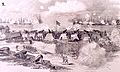
Fort Walker, Battle of Port Royal, November 7, 1861

See also
 In Spanish: Hilton Head Island para niños
