
Hudspeth County, Texas facts for kids
Quick facts for kids
Hudspeth County
|
|
|---|---|

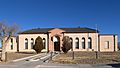
Hudspeth County Courthouse in Sierra Blanca
|
|

Location within the U.S. state of Texas
|
|
 Texas's location within the U.S. |
|
| Country | |
| State | |
| Founded | 1917 |
| Named for | Claude Benton Hudspeth |
| Seat | Sierra Blanca |
| Largest community | Fort Hancock |
| Area | |
| • Total | 4,572 sq mi (11,840 km2) |
| • Land | 4,571 sq mi (11,840 km2) |
| • Water | 0.8 sq mi (2 km2) 0.02% |
| Population | |
| • Estimate
(2020)
|
3,202 |
| • Density | 0.7/sq mi (0.3/km2) |
| Time zone | UTC−7 (Mountain) |
| • Summer (DST) | UTC−6 (MDT) |
| Congressional district | 23rd |
Hudspeth County is a county located in the western part of Texas. A county is like a smaller region within a state, often with its own local government. In 2020, about 3,432 people lived here.
The main town, or county seat, is Sierra Blanca. The biggest community is Fort Hancock. The county is named after Claude Benton Hudspeth. He was a state senator and later a U.S. Representative from El Paso.
Hudspeth County is near the border with Mexico. It's part of the El Paso Metropolitan Statistical Area. This means it's connected to the larger El Paso city area. It's also one of the nine counties in the Trans-Pecos region of West Texas. Hudspeth County, along with El Paso County, uses Mountain Time. This is different from most of Texas, which uses Central Time.
Contents
History of Hudspeth County
Early People and Explorers
Long ago, around 900 to 1350 AD, ancient people called the Jornada Mogollón lived here. They were farmers who grew crops near the Rio Grande river. They left behind cool things like tools and pictographs (rock drawings).
Later, in the late 1500s, Spanish explorers came to the area. The Rodriguez-Sanchez Expedition in 1581 met friendly Native Americans. Another explorer, Antonio de Espejo, met the Otomoaco people in 1582-83.
Native American Life and Challenges
The Mescalero Apache people often visited this area. They used the land to grow their crops. In 1849, an explorer named John Salmon "RIP" Ford wrote about how good the land was for farming for the Mescalero Indians.
By the mid-1600s, the Mescaleros had spread their territory. They were known for being strong and brave. This made it hard for new settlers to move into the area. In the late 1800s, there were some conflicts between soldiers and the Mescalero Apache.
Travel and New Routes
As more people wanted to travel from Texas to California, new routes were needed. In 1848, a path from San Antonio to El Paso was mapped out. Hudspeth County became a place travelers passed through on their journeys.
Fort Quitman was built in 1858. Its job was to protect travelers on these routes. Explorers like Lt. Francis Theodore Bryan also looked for good travel paths and water sources.
The Salt War and Railroads
People living along the Rio Grande near El Paso relied on trading salt. They had a road from Fort Quitman to the Salt Basin in Hudspeth County. But after the Civil War, some politicians tried to control the salt lakes and charge fees for trading salt. This led to a seven-year conflict called the San Elizario Salt War in the 1870s. This war caused a lot of tension between Mexican and American communities.
Later, different railway companies wanted to build tracks through the county. The Texas and Pacific Railway and the Galveston, Harrisburg and San Antonio Railway eventually agreed to share tracks. This led to new towns growing up along the railway lines.
Forming Hudspeth County
Hudspeth County was officially created in 1917. It was formed from parts of El Paso County, Texas. Sierra Blanca was chosen as the county seat. It has a special courthouse made of adobe, which is a type of sun-dried brick.
From 1992 to 2002, the county helped with a unique project. It accepted treated sewage from New York City. This waste was spread over a remote area in the county.
Geography and Nature
Hudspeth County is very large! It covers about 4,572 square miles. Most of this is land, with only a tiny bit of water. It's the third-largest county in Texas by land area. A part of Guadalupe Mountains National Park is located in the northeast corner of the county.
Main Roads
 Interstate 10
 U.S. Highway 62/U.S. Highway 180
 State Highway 20
Neighboring Areas
Hudspeth County shares borders with other counties and even parts of Mexico:
- Otero County, New Mexico (north)
- Culberson County (east)
- Jeff Davis County (south)
- Presidio County (south)
- El Paso County (west)
- Guadalupe, Chihuahua, Mexico (south)
- Práxedis G. Guerrero, Chihuahua, Mexico (south)
Special Natural Places
Population and People
| Historical population | |||
|---|---|---|---|
| Census | Pop. | %± | |
| 1920 | 962 | — | |
| 1930 | 3,728 | 287.5% | |
| 1940 | 3,149 | −15.5% | |
| 1950 | 4,298 | 36.5% | |
| 1960 | 3,343 | −22.2% | |
| 1970 | 2,392 | −28.4% | |
| 1980 | 2,728 | 14.0% | |
| 1990 | 2,915 | 6.9% | |
| 2000 | 3,344 | 14.7% | |
| 2010 | 3,476 | 3.9% | |
| 2020 | 3,202 | −7.9% | |
| U.S. Decennial Census 1850–2010 2010 2020 |
|||
| Race / Ethnicity (NH = Non-Hispanic) | Pop 2000 | Pop 2010 | Pop 2020 | % 2000 | % 2010 | % 2020 |
|---|---|---|---|---|---|---|
| White alone (NH) | 770 | 628 | 1,094 | 23.03% | 18.07% | 34.17% |
| Black or African American alone (NH) | 7 | 30 | 6 | 0.21% | 0.86% | 0.19% |
| Native American or Alaska Native alone (NH) | 33 | 11 | 6 | 0.99% | 0.32% | 0.19% |
| Asian alone (NH) | 4 | 13 | 10 | 0.12% | 0.37% | 0.31% |
| Pacific Islander alone (NH) | 0 | 0 | 0 | 0.00% | 0.00% | 0.00% |
| Other race alone (NH) | 2 | 1 | 7 | 0.06% | 0.03% | 0.22% |
| Mixed race or Multiracial (NH) | 19 | 25 | 43 | 0.57% | 0.72% | 1.34% |
| Hispanic or Latino (any race) | 2,509 | 2,768 | 2,036 | 75.03% | 79.63% | 63.59% |
| Total | 3,444 | 3,476 | 3,202 | 100.00% | 100.00% | 100.00% |
In 2010, there were 3,476 people living in Hudspeth County. Most people were White (78.8%), and a large number were Hispanic or Latino (79.6%).
In 2000, the county had 3,344 people. The population density was less than one person per square mile. This means there's a lot of open space! About 75% of the people were Hispanic or Latino.
Many households (45.3%) had children under 18 living with them. The average household had about 3 people. The median age in the county was 30 years old. This means half the people were younger than 30 and half were older.
Education in Hudspeth County
Hudspeth County has several school districts that serve its students:
- The Fort Hancock Independent School District covers the western part of the county.
- The Culberson County-Allamoore Independent School District serves the eastern part, including Allamoore.
- The Dell City Independent School District covers most of the northern part.
- The Sierra Blanca Independent School District serves most of the southern part, where the county seat is.
In 1995, the Allamoore ISD joined with the Culberson County ISD. All of Hudspeth County is also part of the service area for El Paso Community College.
Communities in Hudspeth County
Cities and Towns
Census-Designated Places
These are areas identified by the census bureau for statistics, but they are not officially incorporated cities.
- Fort Hancock
- Sierra Blanca (the county seat)
Unincorporated Communities
These are smaller communities that are not officially part of a city or town.
Ghost Towns
These are places where people used to live, but now they are mostly abandoned.
Images for kids
-
Hudspeth County Courthouse in Sierra Blanca
See also
 In Spanish: Condado de Hudspeth para niños
