Hurricane Cliffs facts for kids
Quick facts for kids Hurricane Cliffs |
|
|---|---|

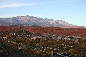
Hurricane Cliffs at Hurricane, Utah
|
|
| Location | |
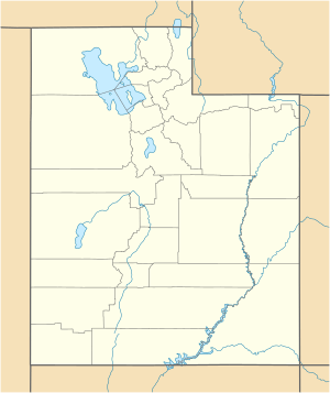
| Coordinates | 37°02′42″N 113°22′05″W / 37.045°N 113.368°W |
The Hurricane Cliffs are amazing red cliffs found in southwest Utah and northwest Arizona. These cliffs are made of a type of rock called limestone. They stretch for about 217 kilometers (135 miles) and mark the western edge of a large rock layer known as the Kaibab Limestone. The southern end of these cliffs is located just north of the famous Grand Canyon.
Contents
What are the Hurricane Cliffs?
The Hurricane Cliffs are a big part of the landforms on the edge of the Colorado Plateau. This area is known as the High Plateaus section. These high plateaus connect to other cool places like the Great Basin to the northwest, the Mojave Desert to the west, and the Arizona transition zone to the southwest and south.
Where do the Cliffs Stretch?
Starting in Arizona, the cliffs head north into Utah. But once they pass Hurricane, near places like Anderson Junction and Pintura, they turn slightly towards the northeast. By the time they reach Cedar City, Cedar Valley, Summit, and the Parowan Valley, they are pointing northeast. The Hurricane Cliffs finally end at the northeast part of Parowan Valley, near the Tushar Mountains.
How do Roads Follow the Cliffs?
Interstate 15, a major highway, runs along the base of these cliffs. It follows them from their northern end, through Parowan Valley, past towns like Paragonah and Parowan. The highway then leaves the cliffs near Anderson Junction and Toquerville.
The Old Spanish Trail and the Cliffs
The Old Spanish National Historic Trail is a historic path that comes down from the northern Markagunt Plateau. It goes through the Hurricane Cliffs and into Parowan Valley, just north of Paragonah. A bit south of there, near Summit and Enoch in northeast Cedar Valley, the Black Mountains get very narrow. The gap between the Hurricane Cliffs and a mountain ridge is only about 1.6 kilometers (1 mile) wide. The Old Spanish Trail used to go through this narrow pass.
Hurricane Cliffs Near Zion National Park
Zion National Park is a famous park located about 14.5 kilometers (9 miles) east of the Hurricane Cliffs, near Toquerville. Zion National Park has many layers of the same Kaibab Limestone rock that makes up the Hurricane Cliffs.
Hurricane Cliffs in Arizona
In Arizona, the Hurricane Cliffs run along the eastern side of Hurricane Wash, which flows north through Black Rock Canyon. From there, the cliffs go south towards Twin Butte, which is 1,846 meters (6,055 feet) high. They continue to Mount Trumbull, which is 2,447 meters (8,028 feet) high, part of the Mount Trumbull Wilderness. The cliffs are next to the Sawmill Mountains and the western side of the Uinkaret Mountains, where they finally stop.
Where Faults and Volcanoes Meet
The western part of the Uinkaret Mountains is where you'll find the Toroweap Overlook. This spot is above Toroweap Point, which sits on a ridge of Coconino Sandstone and Toroweap Formation rocks. This is where the Hurricane Cliffs connect with the Hurricane Fault. It's also where the Hurricane Fault meets the Toroweap Fault. The Toroweap Fault crosses the Grand Canyon from the South Rim and continues north into southern Utah.
This area, where the two faults meet, is also where hot lava can push up through cracks in the rocks. This region is the southeastern part of the Uinkaret volcanic field. Two cool landforms here are Lava Falls and Vulcan's Throne. Lava Falls flows into the Grand Canyon, and Lava Falls Rapids is one of the biggest rapids on the Colorado River.
South of the Colorado River, on the South Rim, you can see the Aubrey Cliffs. These cliffs extend straight south and form the western edge of the Coconino Plateau.
Cities Near the Hurricane Cliffs
Many cities are located at the base of the Hurricane Cliffs. Here is a list of some of them, from north to south, along with their elevation (how high they are above sea level):
- Parowan Valley:
- Paragonah, 1,792 meters (5,879 feet)
- Parowan, 1,834 meters (6,017 feet)
- Summit, 1,815 meters (5,955 feet)
- Cedar Valley:
- Enoch, 1,690 meters (5,545 feet)
- Cedar City, 1,782 meters (5,846 feet)
- Hamilton Fort, 1,697 meters (5,568 feet)
- Kanarraville, 1,689 meters (5,541 feet)
- Pintura
- Anderson Junction
- Toquerville, 1,033 meters (3,389 feet)
- Hurricane, 990 meters (3,248 feet)
See also
 In Spanish: Acantilados Hurricane para niños
 | Charles R. Drew |
 | Benjamin Banneker |
 | Jane C. Wright |
 | Roger Arliner Young |


