Hurricane Karl facts for kids
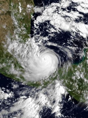
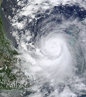
Hurricane Karl at peak intensity, shortly before landfall in Mexico on September 17
|
|
| Meteorological history | |
|---|---|
| Formed | September 14, 2010 |
| Dissipated | September 18, 2010 |
| Category 3 tropical cyclone | |
| 1-minute sustained (SSHWS/NWS) | |
| Highest winds | 125 mph (205 km/h) |
| Lowest pressure | 956 mbar (hPa); 28.23 inHg |
| Overall effects | |
| Fatalities | 22 total |
| Damage | $3.9 billion (2010 USD) |
| Areas affected | Belize, Yucatán Peninsula, Veracruz |
|
Part of the 2010 Atlantic hurricane season |
|
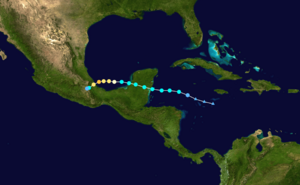
Hurricane Karl was a very strong and damaging tropical cyclone that hit the Mexican state of Veracruz in 2010. It was the eleventh tropical storm, sixth hurricane, and fifth major hurricane of the 2010 Atlantic hurricane season. Karl started as an area of low pressure near Venezuela on September 11. It grew stronger as it moved across the Caribbean Sea.
On September 14, it became Tropical Storm Karl. It first hit the Yucatan Peninsula in Mexico as a strong tropical storm. Then, it quickly gained power in the Bay of Campeche, becoming a major hurricane. This was the first time a major hurricane was seen in the Bay of Campeche. Karl then made landfall near the city of Veracruz on September 17. After hitting land, the storm quickly weakened over the mountains of Mexico and disappeared on September 18.
Hurricane Karl caused a lot of damage. At least 22 people died, mostly in Veracruz. The total damage was about $3.9 billion, making it one of the most destructive storms for Veracruz.
Contents
How Hurricane Karl Formed and Grew
Hurricane Karl began from a mix of weather systems. A low-pressure area formed north of South America in early September. A few days later, a tropical wave (a type of weather disturbance) from Africa joined it. This created a larger low-pressure system that stayed over the Caribbean Sea. Even though the storm clouds were scattered at first, the wind patterns slowly became more organized.
By September 14, a small but clear center of circulation formed. This is when it officially became Tropical Storm Karl. It was about 270 miles (435 km) east of Chetumal, Mexico.
Karl mostly moved west because of a high-pressure area to its north over the Gulf of Mexico. The storm slowly got stronger over very warm ocean waters. It also had low wind shear, which means winds at different heights were not blowing in different directions, allowing the storm to grow.
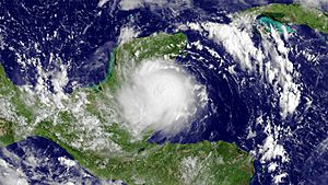
Karl first made landfall on the southeastern coast of Yucatán as a strong tropical storm on September 15. Its winds were about 65 mph (100 km/h). Even as it moved over land, it kept its organized cloud pattern with an eye-like feature.
Around September 16, Karl moved into the Bay of Campeche. Over warm waters again, it quickly became a hurricane. At this time, there were three hurricanes in the North Atlantic: Karl, Igor, and Julia. This was the first time this had happened since 1998.
Karl then went through a period of rapid intensification, meaning it got much stronger very quickly. Its eye became very clear. On September 17, Karl became a Category 3 hurricane. It reached its strongest point with winds of 125 mph (205 km/h) just four hours before hitting land. Karl became the strongest hurricane ever seen in the Bay of Campeche. It hit land near Veracruz, Mexico, as a major hurricane. Once inland, the storm quickly lost power over the high mountains and disappeared by September 18.
Preparing for Hurricane Karl
Western Caribbean Preparations
When the storm formed, the government of Mexico issued a tropical storm warning for the eastern coast of the Yucatán Peninsula. This warning stretched from Chetumal to Cabo Catoche. A tropical storm watch was also put in place for the coast of northern Belize.
In Honduras, officials declared a "green alert" for the whole country, meaning people should be aware. A "yellow alert" was issued for the Bay Islands Department, meaning a higher level of caution. The El Cajón power plant released some water to prevent flooding in nearby areas. Port officials were told to be careful because of rough seas.
In Belize, seaports secured their supplies and stopped operations. Schools were closed in northern districts like Corozal and Orange Walk, and in San Pedro Town and Caye Caulker.
In Quintana Roo, Mexico, officials opened shelters and told people in low-lying areas to leave. Hundreds of people from Banco Chinchorro, a diving center, had to move. In Carillo Puerto, officials prepared concrete homes to shelter hundreds of Mayans from local communities.
As Karl moved inland, "orange alerts" were declared in Campeche for the municipalities of Hopelchén and Calakmul. The rest of the state was under a "yellow alert." Shelters were opened in cities like Campeche and Champotón. Residents were asked not to put out their trash for three days because of heavy rain.
Veracruz Preparations
The government of Veracruz issued a "red alert" as Karl got closer. Eight towns along the coast were ordered to evacuate. The Laguna Verde Nuclear Power Station stopped working as a safety measure.
Pemex, Mexico's oil company, also evacuated its oil facilities in the Gulf of Mexico that were in Karl's path. World oil prices went up on September 17 because Pemex stopped production at 14 of its wells.
Impact of Hurricane Karl
Yucatán Peninsula Impact
When Karl hit Quintana Roo, it brought heavy rain, up to 6.2 inches (157 mm) in some places. This caused scattered flooding. About 54,265 homes lost power, but most got it back within a day. In Chetumal, about 600 homes were flooded with up to 4.9 feet (1.5 m) of water, forcing hundreds to leave.
Strong winds knocked down many trees in Bacalar. Areas like Othon P. Blanco and Carillo Puerto lost a lot of crops. About 11,650 hectares (about 28,800 acres) of crops were affected, with 3,477 hectares of corn destroyed. Around 7,800 hectares of sugarcane were lost, causing about $6.23 million in economic losses. Damage to roads, buildings, and properties in Othon P. Blanco was estimated at about $9.9 million.
In Belize, strong winds knocked down power poles and caused power outages near the border. In Campeche, there was not much rain or damage. Luckily, no one died in the Yucatán Peninsula because the storm hit a less populated area.
Gulf Coast of Mexico Impact
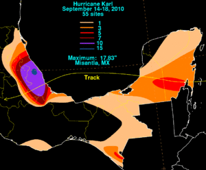
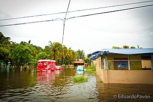
Karl brought very heavy rains to Veracruz, causing major flooding. Some areas, like Misantla, received up to 17.83 inches (455 mm) of rain. When the hurricane hit, its strong winds knocked down hundreds of thousands of trees and caused widespread power outages. About 280,000 homes lost electricity.
The disaster affected at least 163 of the state's 212 municipalities. Days after the storm, more than half of the state was still underwater. About 150,000 people had to leave their homes and go to 423 storm shelters. Karl caused the deaths of 12 people in Veracruz.
The damage to buildings in Veracruz was very bad. In Cotaxtla, muddy waters reached up to 39 feet (12 m) high, covering many buildings in mud. The flooding was described as "unprecedented," meaning it had never been seen before. In Boca del Río, near the Jamapa River, the winds knocked down over 400,000 trees. These trees clogged the river mouth, causing about 30,000 people to evacuate.
In Puebla, two people died when their home was destroyed by a landslide. Another person died in Tabasco after drowning in her flooded home. About 200,000 homes lost power because of Karl.
In total, Karl killed 16 people and 11 others went missing. About 15.8 million people in Mexico were affected by the storm. The total economic losses in Mexico were estimated at about $3.9 billion.
Aftermath of Hurricane Karl
After the severe flooding from Karl, about 3,500 people found safety in shelters set up in schools across Veracruz. It is believed that between 250,000 and 500,000 people lost their homes because 120 towns in the state experienced widespread floods. Emergency officials kept warnings in place even after Karl passed, to keep people informed of ongoing dangers. In the weeks after the hurricane, cleanup crews removed about 18,000 tons of debris from Veracruz.
Even though Karl caused a lot of damage, its name was not removed from the list of hurricane names. It was used again in 2016. Karl was actually the most expensive storm that didn't have its name retired, until Imelda and several hurricanes in 2020, like Sally, caused even more damage without their names being retired.
See also
 In Spanish: Huracán Karl para niños
- Tropical cyclones in 2010
- List of Category 3 Atlantic hurricanes
- Hurricane Ella (1970)
- Hurricane Diana (1990)
- Hurricane Stan (2005)
- Hurricane Franklin (2017)
- Hurricane Grace (2021)
 | Jackie Robinson |
 | Jack Johnson |
 | Althea Gibson |
 | Arthur Ashe |
 | Muhammad Ali |


