Irish Sea facts for kids
Quick facts for kids Irish Sea |
|
|---|---|

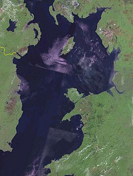
Satellite image
|
|

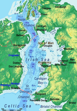
Bathymetry, limits and ports:
◘ = ferry port / ◘ = freight port only |
|
| Location | between Great Britain and Ireland |
| Coordinates | 53°N 5°W / 53°N 5°W |
| Type | Sea |
| Basin countries | United Kingdom; Republic of Ireland; Isle of Man |
| Surface area | 46,007 km2 (17,763 sq mi) |
| Water volume | 2,800 km3 (2.3×10⁹ acre⋅ft) |
| Islands | Anglesey and Holy Island, Isle of Man and Calf of Man, Bardsey Island, Walney, Lambay, Ireland's Eye |
| Settlements | (see below) |

The Irish Sea (sometimes called the Manx Sea) is a body of water that separates Ireland and Great Britain. It is a very important sea for the countries around it. People use it for trade, shipping, and fishing. It also helps create power through wind power and nuclear plants. Every year, over 12 million passengers and 17 million tons of goods travel across this sea.
About the Irish Sea
The Irish Sea covers a large area of about 46,007 square kilometers (17,374 square miles). At its deepest point, the sea is about 300 meters (984 feet) deep.
How the Sea is Used
The Irish Sea is very important for the economy of the nearby countries. In 2008, about 38 million tons of fish were caught here. Most of this catch, about three-quarters, was shellfish.
The sea also has valuable energy resources. There are 17 active platforms that drill for oil and natural gas. Experts believe there might be as much as 1.6 billion barrels of oil in just one area called the Barryroe oil field.
Amazing Sealife
The Irish Sea is home to many different kinds of marine animals. At least thirty types of sharks can be found here at different times of the year. These include large sharks like the basking shark, thresher shark, blue shark, mako shark, and porbeagle shark.
You can also find about 12 different species of Dolphin, porpoise, and whales in the Irish Sea. Some common ones are the common dolphin, bottlenose dolphin, and the harbor porpoise.
Images for kids
-
From the pier at Dún Laoghaire, a seaside town in County Dublin, Ireland
-
Barrow Offshore windfarm, off Walney Island
See also
 In Spanish: Mar de Irlanda para niños
 | John T. Biggers |
 | Thomas Blackshear |
 | Mark Bradford |
 | Beverly Buchanan |


