Juniata County, Pennsylvania facts for kids
Quick facts for kids
Juniata County
|
|
|---|---|
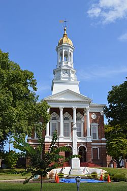
Juniata County Courthouse in Mifflintown
|
|
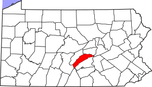
Location within the U.S. state of Pennsylvania
|
|
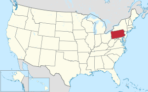 Pennsylvania's location within the U.S. |
|
| Country | |
| State | |
| Founded | March 2, 1831 |
| Named for | Juniata River |
| Seat | Mifflintown |
| Largest borough | Port Royal |
| Area | |
| • Total | 394 sq mi (1,020 km2) |
| • Land | 391 sq mi (1,010 km2) |
| • Water | 2.2 sq mi (6 km2) 0.6%% |
| Population
(2020)
|
|
| • Total | 23,509 |
| • Density | 60/sq mi (20/km2) |
| Time zone | UTC−5 (Eastern) |
| • Summer (DST) | UTC−4 (EDT) |
| Congressional district | 13th |
Juniata County is a county located in the state of Pennsylvania. In 2020, about 23,509 people lived here. The main town, or county seat, is Mifflintown.
The county was formed on March 2, 1831. It was created from a part of Mifflin County. The county gets its name from the Juniata River. Juniata County is part of the Central Pennsylvania region.
This area has mountains like Tuscarora Mountain and Shade Mountain. Most of the land is used for farming or is covered by forests. Important rivers and creeks include the Susquehanna River and the Juniata River. Juniata County shares its borders with seven other counties.
The county has a lower population compared to many other places. The towns of Mifflintown and Mifflin are the most populated areas. Many main roads cross through Juniata County, connecting its towns and villages.
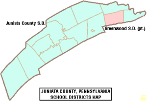
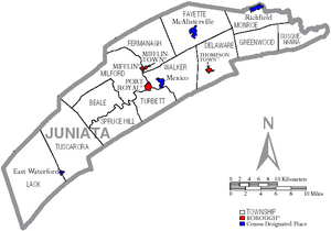
Juniata County has four boroughs (small towns) and thirteen townships (larger rural areas). Two school districts serve the county: the Juniata County School District and Greenwood School District. There are also special natural areas protected by the Central Pennsylvania Conservancy.
The first European settlers came to Juniata County in the 1750s. Before it became its own county, it was part of Mifflin County, and even earlier, Cumberland County.
Contents
- Exploring Juniata County's Past
- Understanding Juniata County's Landscape
- Understanding the Land: Geology and Soils
- People and Population
- Jobs and Money in Juniata County
- Getting Around Juniata County
- Learning in Juniata County: Schools and Education
- Nature and Wildlife in Juniata County
- Communities of Juniata County
- See also
Exploring Juniata County's Past
Juniata County has a rich history. It was officially formed on March 2, 1831. The county was named after the Juniata River. The word "Juniata" comes from the Seneca language. It means either "people of the standing stone" or "blue waters."
The first towns to be settled were Mifflintown and Thompsontown in 1790. Later, Port Royal was settled in 1812 and Mifflin in 1848. Mifflintown was the first town to become official in 1833.
Early settlers, sometimes called squatters, arrived in the area even before 1750. The first land permits were given out in 1755. During this time, there were some Native American raids in 1755 and 1756. Fort Bingham and Fort Peterson were built to help protect the settlers.
More settlers came in the 1750s and 1760s. The first gristmill (a mill for grinding grain) on the western side of the Juniata River was built in 1767. A public road was built in 1768. The first known doctor in the county, Dr. Ezra Doty, arrived in Mifflintown in 1791.
The area that would become Juniata County was first divided into four townships in 1754. These were Lack, Aire, Fannett, and Tyrone. By 1913, these original townships had been divided into 13 townships.
Canals and railroads played a big role in the county's transportation. The Pennsylvania Canal started serving Juniata County in 1826. The Pennsylvania Railroad arrived in the late 1840s.
Historic Landmarks to Discover
Juniata County is home to several important historic places. Eight locations are listed on the National Register of Historic Places. These include:
- The Academia Pomeroy Covered Bridge
- The Tuscarora Academy
- The Book site in Beale Township
- The Lehmans-Port Royal Bridge in Milford Township
- The East Oriental and North Oriental covered bridges
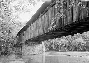
The Academia Pomeroy Covered Bridge was built in 1901. It is one of the longest remaining covered bridges in Pennsylvania. It is 18 feet (5.5 meters) wide and 278 feet (85 meters) long.
There are also five Pennsylvania Historical and Museum Commission historical markers. These markers tell the stories of places like the Tuscarora Path, Tuscarora Academy, and Fort Bingham.
Understanding Juniata County's Landscape
Juniata County covers about 394 square miles (1,020 square kilometers). Most of this area, 391 square miles (1,013 square kilometers), is land. Only a small part, 2.2 square miles (5.7 square kilometers), is water.
The county is located between two larger cities: State College to the northwest and Harrisburg to the southeast. Major highways like U.S. Route 22 and U.S. Route 322 connect the county to these areas.
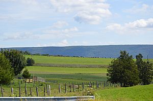
While some parts of Juniata County are flat, many areas are hilly. Mountains form parts of the county's borders. Tuscarora Mountain is on the border with Perry County. Shade Mountain runs through the county from Snyder County.
Two special places in Juniata County are known for their beautiful views: Hawstone Overlook and the Concord Narrows.
- Hawstone Overlook in Milford Township offers amazing views of the Juniata River. You can see it flowing between Shade Mountain and Blue Mountain.
- The Concord Narrows is a narrow water gap where the Juniata River cuts through Tuscarora Mountain.
Rivers and Waterways
Juniata County has several important streams and rivers. These include:
- The Susquehanna River
- The Juniata River
- Tuscarora Creek
- Cocolamus Creek
- West Branch Mahantango Creek
- Licking Creek
- Lost Creek
A large part of the county, about 45% of its area, is within the Tuscarora Creek watershed. This includes the town of Port Royal. About 24% of the county is in the Juniata River watershed, which includes parts of all four boroughs.
How Land is Used
Most of Juniata County is rural, meaning it's countryside.
- About one-fifth of the county's land is used for homes. Most of these are single-family houses.
- A large portion, 41%, is used for farming.
- About two-thirds of the county is covered by forests. The southwestern part of the county has many forests.
There are also small villages and hamlets scattered throughout the county. Areas near Mifflin and Mifflintown are considered "high growth areas" for housing.
Weather and Climate
Juniata County has a humid continental climate. This means it has warm summers and cold winters.
- In July, average temperatures are around 73.2°F (22.9°C).
- In January, average temperatures are around 28.1°F (-2.2°C).
The county gets about 38 inches (97 cm) of rain each year. On average, about 28 inches (71 cm) of snow falls each winter.
Neighboring Counties
Juniata County shares its borders with these counties:
- Mifflin County (north)
- Snyder County (north)
- Northumberland County (east)
- Dauphin County (southeast)
- Perry County (south)
- Franklin County (south)
- Huntingdon County (west)
Understanding the Land: Geology and Soils
Juniata County sits on top of 16 different types of rock formations. These rocks formed during the Ordovician Period, the Silurian Period, and the Devonian Period. Some of these rock formations contain limestone.
The northern part of the county has rocks like the Juniata Formation and Bald Eagle Formation, which are mostly sandstone. Further south, you'll find formations like the Bloomsburg and Mifflintown Formation, which are mainly shale.
The county also has 51 different types of soils. About 18 of these are considered excellent for farming. The Hazelton-Laidig-Buchanan Association is a deep, well-drained soil found in about 24% of the county, mostly in forested areas. The Berks-Weikert-Bedington Association is another common soil, found in 33% of the county, often in farmlands.
People and Population
| Historical population | |||
|---|---|---|---|
| Census | Pop. | %± | |
| 1840 | 11,080 | — | |
| 1850 | 13,029 | 17.6% | |
| 1860 | 16,986 | 30.4% | |
| 1870 | 17,390 | 2.4% | |
| 1880 | 18,227 | 4.8% | |
| 1890 | 16,655 | −8.6% | |
| 1900 | 16,054 | −3.6% | |
| 1910 | 15,013 | −6.5% | |
| 1920 | 14,464 | −3.7% | |
| 1930 | 14,325 | −1.0% | |
| 1940 | 15,373 | 7.3% | |
| 1950 | 15,243 | −0.8% | |
| 1960 | 15,874 | 4.1% | |
| 1970 | 16,712 | 5.3% | |
| 1980 | 19,188 | 14.8% | |
| 1990 | 20,625 | 7.5% | |
| 2000 | 22,821 | 10.6% | |
| 2010 | 24,636 | 8.0% | |
| 2020 | 23,509 | −4.6% | |
| U.S. Decennial Census 1790-1960 1900-1990 1990-2000 2010-2017 |
|||
In 2010, Juniata County had 24,636 people living in 9,476 households. The population density was about 63 people per square mile. Most of the people living in the county are White (96.8%). About 2.5% of the population is Hispanic or Latino.
The towns of Mifflintown, Mifflin, and Thompsontown have the highest population densities. The most rural areas with the lowest population densities are Lack Township, Tuscarora Township, and Greenwood Township.
Between 1940 and 2005, Juniata County's population grew quite a bit, increasing by over 50%. This was one of the fastest growth rates in Pennsylvania during that time.
In 2010, the population was spread out across different age groups.
- About 6.3% were under 5 years old.
- About 6.8% were between 5 and 9 years old.
- About 6.8% were between 10 and 14 years old.
- About 7.6% were between 50 and 54 years old.
- About 2.3% were older than 85 years.
2020 Census Snapshot
| Race | Num. | Perc. |
|---|---|---|
| White (NH) | 21,830 | 93% |
| Black or African American (NH) | 115 | 0.5% |
| Native American (NH) | 19 | 0.1% |
| Asian (NH) | 69 | 0.3% |
| Pacific Islander (NH) | 4 | 0.02% |
| Other/Mixed (NH) | 564 | 2.4% |
| Hispanic or Latino | 908 | 3.86% |
Jobs and Money in Juniata County
Juniata County has a healthy local economy. In 2000, many people worked in manufacturing. Other common jobs were in health services, construction, and retail.
Farming is a very important industry here.
- Livestock farming, especially poultry and dairy, is more common than growing crops.
- In 2002, the county's egg and poultry industry made $32 million in sales.
- The dairy industry brought in $17 million.
- Juniata County is the fourth biggest poultry-producing county in Pennsylvania!
The county has one public library, the Juniata County Library in Mifflintown. It has many books and materials for everyone to use.
There are no hospitals directly in Juniata County. Residents use a hospital in nearby Lewistown. The county has six emergency medical services units and eight volunteer fire companies. The Pennsylvania State Police serve as the police force for the county.
Homes and Housing
Many homes in Juniata County were built before 1939. However, many new homes have also been built since the 1970s.
In 2000, about 14.43% of the houses in Juniata County were empty. Many of these were seasonal homes used for vacations. Most homes (66.49%) are owned by the people who live in them.
The median value of a house in Juniata County was $87,000 in 2000. This was an increase from $51,500 in 1990.
Fun and Recreation
Juniata County offers several places for fun and recreation.
- All four boroughs have municipal parks.
- There are five boat launches, mostly on or near the Juniata River.
- You can find two golf courses in the central part of the county.
- There is also one campground in the southern part of the county for outdoor adventures.
Getting Around Juniata County
Roads and Highways
The main roads in Juniata County help people travel easily.
- In the eastern part, you'll find Pennsylvania Route 235, Pennsylvania Route 35, Pennsylvania Route 104, and U.S. Route 11/U.S. Route 15.
- In the western part, key roads include U.S. Route 22/U.S. Route 322, Pennsylvania Route 74, Pennsylvania Route 850, and Pennsylvania Route 333.
U.S. Route 22/U.S. Route 322 is the busiest road, with 11,000 to 18,000 vehicles using it daily. These major roads help residents connect to other parts of Pennsylvania and even New York and Maryland.
There are about 735 miles (1,183 km) of roads in Juniata County. Most of these roads are owned by local governments or the Pennsylvania Department of Transportation.
Bridges
Juniata County has 254 state-owned bridges. The longest bridge is the First Street Bridge over the Juniata River in Port Royal. It is 1,087 feet (331 meters) long and was built in 1937.
Other Ways to Travel
For air travel, Juniata County has the privately owned Mifflintown Airport. There is also the Stottle Memorial Heliport for helicopters.
If you enjoy biking, the BicyclePA Route J runs through Juniata County. It follows U.S. Route 11 and U.S. Route 15.
Learning in Juniata County: Schools and Education
Juniata County is served by two public school districts:
- The Juniata County School District
- The Greenwood School District
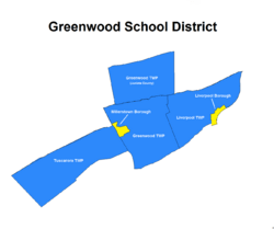
Both districts offer education from kindergarten through 12th grade. The Greenwood School District serves Greenwood Township and parts of Perry County. The Juniata County School District serves the rest of Juniata County.
The Juniata County School District has changed over time. In the 2018–2019 school year, its elementary schools were combined into two main schools: Juniata Elementary and East Juniata Elementary Schools.
The Greenwood School District has an elementary school, a middle school, and a high school.
In addition to public schools, there are 12 private schools in Juniata County. Many of these are religious schools run by groups like the Amish or other types of Mennonites. Most are located in Mifflintown, McAlisterville, or Thompsontown. The Juniata Christian School is one of the largest private schools.
There are no colleges directly in Juniata County, but there are several in nearby areas.
Education Statistics
Education levels in Juniata County have improved over the years.
- In 1990, about 46.35% of adults over 25 had graduated from high school.
- By 2000, this percentage had changed, with more people attending college or earning degrees.
Lack Township has the highest percentage of people without a high school diploma. Mifflintown has the highest percentage of people with a higher education.
Nature and Wildlife in Juniata County
Juniata County is home to many natural areas.
- The Central Pennsylvania Conservancy protects five areas here, totaling 415 acres. These include the Baker Easement and the Port Royal Wetlands.
- There are also Pennsylvania State Game Lands in the northwestern part of the county.
- State forests can be found in the northern and southern parts of the county.
Several streams in Juniata County are known as high-quality coldwater fisheries. Some areas also have Class A Wild Trout Waters, which are great for trout fishing.
The Juniata County Natural Heritage Inventory lists 59 important natural sites. These sites are found in almost every township in the county.
Wetlands and Unique Habitats
- The Cedar Spring Run Wetland in Walker Township is one of the largest remaining natural wetlands in the county. It's home to rare plants like Quercus shumardii (Shumard oak).
- The Locust Run Wetlands in Walker and Delaware Townships have many temporary and permanent pools.
- The West Branch Mahantango Creek Vernal Pools are dozens of temporary pools where unique plants like Leucothoe racemosa (fetterbush) grow.
Forests and Special Plants
- The Doyle Run Floodplain in Beale Township has a silver maple floodplain forest. It's home to many plant and animal species that are rare in Pennsylvania.
- Barton Hollow, a stream in Lack Township, has unique plants like Carex careyana and Pinus echinata (shortleaf pine). It's also home to animals like the Emperor Butterfly and a mussel species called the Triangle Floater.
- The Kurtz Valley Woodland in Delaware Township has a rare red cedar–redbud shrubland.
- The McAlister Limestone Glade in Fayette Township has a special type of grassland called a side-oats grama calcareous grassland.
Wildlife Habitats
The Lewistown Narrows in Milford Township is an important habitat. Allegheny Woodrats live on its slopes, and Northern Myotis bats feed there.
Communities of Juniata County
In Pennsylvania, there are different types of towns and areas. Juniata County has boroughs and townships.
Boroughs
These are smaller, incorporated towns:
- Mifflin
- Mifflintown (This is the county seat!)
- Port Royal
- Thompsontown
Townships
These are larger, often more rural, areas:
- Beale
- Delaware
- Fayette
- Fermanagh
- Greenwood
- Lack
- Milford
- Monroe
- Spruce Hill
- Susquehanna
- Turbett
- Tuscarora
- Walker
Unincorporated Community
- Oakland Mills
Census-Designated Places (CDPs)
These are areas defined by the U.S. Census Bureau for data collection. They are not official towns.
Population Ranking (2010 Census)
Here's how the main communities in Juniata County ranked by population in 2010:
| Rank | City/Town/etc. | Municipal type | Population (2010 Census) |
|---|---|---|---|
| 1 | McAlisterville | CDP | 971 |
| 2 | † Mifflintown | Borough | 936 |
| 3 | Port Royal | Borough | 925 |
| 4 | Thompsontown | Borough | 697 |
| 5 | Mifflin | Borough | 642 |
| 6 | Richfield (partially in Snyder County) | CDP | 549 |
| 7 | Mexico | CDP | 472 |
| 8 | East Waterford | CDP | 196 |
| 9 | East Salem | CDP | 196 |
See also
 In Spanish: Condado de Juniata para niños
 | Emma Amos |
 | Edward Mitchell Bannister |
 | Larry D. Alexander |
 | Ernie Barnes |


