
Lake Estancia facts for kids
Quick facts for kids Lake Estancia |
|
|---|---|

Lake Estancia
Location in New Mexico
|
|
| Location | Estancia Valley, New Mexico |
| Coordinates | 35°N 106°W / 35°N 106°W |
| Type | former lake |
| Max. length | 56 kilometres (35 mi) |
| Max. width | 37 kilometres (23 mi) |
Lake Estancia was a large ancient lake in the Estancia Valley in central New Mexico. It existed during the ice ages. The lake's water levels changed a lot over time. It left behind many landforms like old beaches.
Fish like Cutthroat trout lived in the lake. They might have arrived when the lake was full and overflowing. The lake got most of its water from streams and groundwater flowing from the Manzano Mountains. Sometimes the lake was fresh, and other times it was salty.
Lake Estancia formed a long time ago, between the Pliocene and Pleistocene eras. It was one of many "pluvial lakes" in the southwestern United States. These lakes grew bigger during the ice ages. This happened because temperatures were lower and there was more rain.
Scientists study Lake Estancia to learn about past climates. Its history helps us understand how weather patterns changed over thousands of years.
Contents
Where Was Lake Estancia?
Lake Estancia was in the Estancia Valley. This is a closed basin (a bowl-shaped area with no rivers flowing out) in central New Mexico. It's about 70 kilometers (43 miles) southeast of Albuquerque.
Towns like Estancia, Moriarty, and Willard are now in the valley. Major roads like Interstate 40 cross the old lakebed. The Salinas Pueblo Missions National Monument is also near where the lake used to be.
The Estancia Valley is surrounded by hills and mountains. These include the Pedernal Hills and the Manzano Mountains. The valley covers about 5,000 square kilometers (1,900 square miles).
Today, the center of the valley has over sixty playas. These are flat, dry lakebeds that only hold water for short times. They are not what's left of Lake Estancia itself. The lowest point in the valley is about 1,850 meters (6,070 feet) high.
What the Lake Looked Like
Lake Estancia was huge, about 56 kilometers (35 miles) long and 37 kilometers (23 miles) wide. It covered areas where towns like Estancia and Willard are now. It might have looked a bit like Lake Tahoe in California, but Lake Tahoe is much deeper.
The lake was the easternmost large ancient lake in the Southwestern United States. You can still see signs of its old shorelines. These include old beaches, ridges, and cliffs. Some ridges are made of gypsum and can be very long.
Water levels in the lake changed a lot. At its deepest, it could have been 125 meters (410 feet) deep. It would have covered an area of 2,340 square kilometers (900 square miles). During drier times, it was much shallower, sometimes just a few meters deep.
Streams from the Manzano Mountains flowed into the lake. They formed deltas where they met the lake. These streams brought dirt and rocks into the lake.
Lake Deposits and Gypsum Dunes
When the lake was full, it left behind layers of clay and gypsum. These layers are called the Dog Lake Formation. When the lake dried up, gypsum from the lakebed was blown by the wind. This created special dunes called gypsum dunes.
These dunes cover about 120 square kilometers (46 square miles) in the Estancia Valley. They are a rare type of dune. The wind also carved out hollows in the dry lakebed.
How the Lake Got Water
The lake was fed by streams and groundwater. When the lake was full, streams were the main source of water. When it was lower, groundwater was more important. The Manzano Mountains were the main source of this water.
The area that collected water for the lake was about 5,050 square kilometers (1,950 square miles). This was a large area compared to the lake's size. This is because the lake was at a high elevation. Higher places usually have cooler temperatures, so less water evaporates.
The water originally came from the Pacific Ocean. Winds carried the moisture to Lake Estancia. The groundwater helped keep the lake's water levels steady.
The lake's saltiness changed over time. Sometimes it was very salty, and other times it was fresh. During the ice age, the lake water was cool, about 10°C (50°F). Strong winds kept the water mixed, so it didn't form layers.
Did the Lake Overflow?
Scientists have studied whether Lake Estancia ever overflowed. There's a low point (a "saddle") to the south that could have allowed water to spill out. Early studies didn't find clear evidence of overflow.
Later research also suggests it probably didn't overflow during the last ice age. If it did, it would have been more than 130,000 years ago. If it had overflowed, the water would have gone into other basins to the southeast. This would have created an even larger connected lake system.
Past Climate Conditions
Today, the Estancia Valley is dry. The average temperature is about 10°C (50°F). It gets less than 300 millimeters (12 inches) of rain each year. Much more water evaporates than falls as rain. This is why there are no permanent lakes there now.
But during the ice ages, when Lake Estancia existed, the climate was different. Summers were colder than today. There was more rain, especially in the southern part of New Mexico. Temperatures were about 10°C (18°F) colder. This caused the snowline in the mountains to drop. More snow meant more water flowing into rivers and streams.
Lake Estancia was one of many lakes that grew bigger during the ice ages. Scientists believe this happened because of changes in global weather patterns. The large Laurentide Ice Sheet in North America changed how air moved. This brought more rain to the region and reduced evaporation.
Animals and Plants of Lake Estancia
Fossils show that cutthroat trout lived in Lake Estancia. It seems to be the only fish species found there. These fish were likely present when the lake was freshwater. They might have survived dry periods in the streams that fed the lake. But they died out when the climate became too dry.
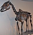
Other animal fossils found include ducks, large ancient horses, and tiger salamanders. Mammoths also lived near the lake.
Based on pollen found in the lake deposits, the area around Lake Estancia was a sagebrush grassland. The nearby Manzano Mountains had pine and spruce forests. All this water and plant life meant there was plenty of food for grazing animals.
The lake deposits also contain fossils of tiny living things. These include different types of algae, diatoms, and molluscs. When the lake dried up, these creatures disappeared. Plants like ditch grass and stonewort grew in the wet, salty soils.
How Lake Estancia Changed Over Time
The Estancia Valley became a closed basin (meaning water couldn't flow out) a very long time ago. This happened because of fault movements in the Earth's crust. Before that, a river flowed through the valley and out to the Pecos River.
The lake started to form in the middle Pleistocene epoch. An early, very large Lake Estancia likely existed during the Illinoian glaciation. It then mostly dried up during a warm, dry period.
Scientists have studied the lake's history using drills to get samples from the lakebed. These samples show how water levels changed over thousands of years.
The Last Ice Age and Beyond
About 24,000 years ago, water levels in Lake Estancia began to rise again. During the last glacial maximum (LGM), the lake had several high water periods. This was caused by the growth of the Laurentide Ice Sheet, which pushed weather patterns south.
Around 18,100 to 17,000 years ago, the lake levels dropped sharply. This dry period is called the "Big Dry." After this, the lake filled up again in a period called the "Big Wet." This was the highest water level in the last 30,000 years.
The lake dried up again about 12,000 to 14,000 years ago. This was due to a drier climate. The exposed lakebed was then shaped by wind, creating dunes.
A final, brief high water period, called "Lake Willard," happened about 11,000 to 10,000 years ago. This was during a cooler, wetter time called the Younger Dryas. But eventually, Lake Estancia completely dried up during the Holocene epoch.
Why the Lake Disappeared
Lake Estancia fully dried up about 8,500 years ago. This happened because of La Niña conditions. These conditions reduced the amount of water flowing into the lake. The high evaporation rates in the valley meant the lake couldn't hold water anymore.
After the lake dried, strong winds continued to shape the land. They created the flat, dry lakebeds (playas) we see today. Dunes also formed during hot and dry periods.
People and the Lake's Importance
Humans first arrived in the Estancia Basin when Lake Estancia was dry. But as the lake levels rose again, its shores became good places for people to live. Many ancient tools and points have been found near the old shorelines.
Long after the lake dried up, Spanish explorers reported that Pueblo Indians traded salt from the dry lake basin.
Scientists first reported evidence of these ancient lakes in 1903. Lake Estancia's climate record is one of the best studied in New Mexico. Its large size meant it reacted strongly to regional climate changes. This makes it a valuable source of information about past climates.
- Bachhuber, Frederick W. (1 December 1989). "The occurence [sic] and paleolimnologic significance of cutthroat trout (Oncorhynchus clarki) in pluvial lakes of the Estancia Valley, central New Mexico" (in en). GSA Bulletin 101 (12): 1543–1551. doi:10.1130/0016-7606(1989)101<1543:TOAPSO>2.3.CO;2. ISSN 0016-7606. https://pubs.geoscienceworld.org/gsa/gsabulletin/article/101/12/1543/182239.
Images for kids
-
Equus occidentalis skeleton

