Landmarks of the Nebraska Territory facts for kids
Landmarks of the Nebraska Territory were super important for early settlers traveling west. These brave pioneers used famous routes like the Oregon, California, and Mormon trails. Many of these special places were near the Platte River, but others were found all over what is now Nebraska. They helped guide travelers and offered places to rest or get supplies.
Contents
- Journeying West: The Famous Trails
- Discovering Nebraska's Historic Landmarks
- Important Stops Along the Way
- Rock Creek Station: A Pony Express Stop
- Oak Grove Station: A Place of History
- Spring Ranch: A Busy Trading Post
- Susan Hail Grave: A Pioneer's Rest
- Fort Kearny: A Safe Haven
- Midway Station: Mark Twain's Mention
- Cottonwood Springs: Precious Water
- Fort McPherson: A Military Post
- O'Fallon's Bluff: A Strategic Spot
- Beauvais Trading Post: A Place to Trade
- California Crossing: A River Challenge
- Windlass Hill and Ash Hollow: A Steep Descent
- Courthouse and Jail Rocks: Natural Wonders
- Chimney Rock: A Famous Landmark
- Rebecca Winters' Gravesite: A Mormon Pioneer's Story
- Scotts Bluff: A Towering Guide
- Mitchell Pass: A Path Through the Hills
- Robidoux Pass and Trading Post: A Trapper's Stop
- Important Stops Along the Way
- See also
Journeying West: The Famous Trails
Imagine a time when there were no highways, just dirt paths across vast lands! The Nebraska Territory was a key part of these journeys. The Oregon and California Trails entered the area from what was then the Kansas Territory. They wound their way west and northwest across the land we now call Nebraska.
The Mormon Trail had a slightly different path. It started in the Nebraska Territory at a place called Cutler's Park. This was right across the Missouri River from Kanesville, Iowa. From there, it followed the Elkhorn and Platte rivers, heading west. These trails were like ancient highways, guiding thousands of people to new homes.
Discovering Nebraska's Historic Landmarks
Along these trails, pioneers found many natural and man-made landmarks. These spots were crucial for navigation, safety, and rest. Let's explore some of the most famous ones.
Important Stops Along the Way
Many places along the trails offered more than just a view. They were vital for survival and communication.
Rock Creek Station: A Pony Express Stop
Near Endicott, you would find Rock Creek Station. This was a busy Pony Express station, where riders would swap horses to deliver mail quickly. Today, it's a State Historical Park. It's also known for a famous event in 1861 involving Wild Bill Hickok.
Oak Grove Station: A Place of History
Another Pony Express station was Oak Grove Station near Oak. A monument there remembers a historical event from 1864. These stations were like modern-day rest stops, but much more basic!
Spring Ranch: A Busy Trading Post
Near Pauline, Spring Ranch was a lively spot. It served as a stagecoach stop, a trading post, and even a small village. Pioneers could get supplies or send messages from places like this.
Susan Hail Grave: A Pioneer's Rest
Near Kenesaw, you can find the grave of Susan Hail. She passed away on June 2, 1852. Her husband, filled with sadness, brought a tombstone all the way from St. Joseph by wheelbarrow. This shows the deep love and hardship faced by those traveling west.
Fort Kearny: A Safe Haven
Fort Kearny (also called Fort Childs) was located near what is now Kearney. It was an open fort built from sod and adobe bricks. This fort was a crucial place for pioneers to feel safe and get help during their long journey.
Midway Station: Mark Twain's Mention
Near Gothenburg was Midway Station. Built in 1855 as a trading post, it later became an Overland stage and Pony Express station. Even famous writer Mark Twain mentioned it in his book, Roughing It!
Cottonwood Springs: Precious Water
Near Maxwell, Cottonwood Springs was a lifesaver. It was known as the only source of good water for miles around. Finding fresh water was incredibly important for both people and animals on the trails.
Fort McPherson: A Military Post
Also near Maxwell was Fort McPherson. This fort played a big role during the conflicts known as the Indian Wars. Today, the Fort McPherson National Cemetery is there, honoring many who served.
O'Fallon's Bluff: A Strategic Spot
O'Fallon's Bluff was on the south bank of the South Platte River, near Sutherland. It was an important location for a stage station and a military post, helping to keep the trails safe.
Beauvais Trading Post: A Place to Trade
Near Brule, Beauvais Trading Post was set up in 1859 by Geminien P. Beauvais. It was a key spot for trading goods and was close to a famous river crossing called the Upper Crossing.
California Crossing: A River Challenge
Also near Brule, California Crossing was where pioneers had to cross the South Platte River. River crossings were often dangerous and challenging parts of the journey.
Windlass Hill and Ash Hollow: A Steep Descent
The area near Big Springs and Lewellen included Windlass Hill and Ash Hollow State Historical Park. Windlass Hill was a very steep slope that pioneers had to carefully navigate. Ash Hollow was a welcome resting place after such a difficult descent.
Courthouse and Jail Rocks: Natural Wonders
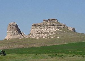
Near Bridgeport, pioneers saw the amazing Courthouse and Jail Rocks. Courthouse Rock is a huge sandstone rock formation. A smaller one nearby was called Jail Rock. Their unique shapes made them easy to spot.
Chimney Rock: A Famous Landmark
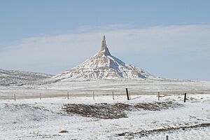
One of the most famous landmarks was Chimney Rock National Historic Site, near Bayard. This tall column of clay and sandstone looked like a giant factory chimney. It stood over 300 feet (91 meters) tall and was a sign that pioneers were getting closer to the mountains.
Rebecca Winters' Gravesite: A Mormon Pioneer's Story
Near Scottsbluff is the gravesite of Rebecca Winters. She was a Mormon pioneer who passed away in 1852 while traveling to the Utah Territory. Her grave is a reminder of the many lives lost on the journey.
Scotts Bluff: A Towering Guide
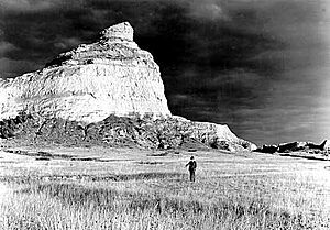
Scotts Bluff, near Gering, is a huge bluff overlooking the North Platte River. It was a major landmark for all the trails. Today, it's a National Monument, protecting this important piece of history.
Mitchell Pass: A Path Through the Hills
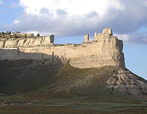
Also near Gering, Mitchell Pass was a gap in the Wildcat Hills. After 1851, the United States Army Corps of Engineers improved this path, making it easier for travelers. It's now part of Scotts Bluff National Monument.
Robidoux Pass and Trading Post: A Trapper's Stop
Near Gering, Robidoux Pass and Trading Post was a small log trading post. It was set up by Joseph E. Robidoux in 1848. Trappers and pioneers could stop here for supplies and news.
See also
 | Selma Burke |
 | Pauline Powell Burns |
 | Frederick J. Brown |
 | Robert Blackburn |


