Laurel Canyon, Los Angeles facts for kids
Quick facts for kids
Laurel Canyon, Los Angeles
|
|
|---|---|
| Country | |
| State | |
| County | |
| City | |
| Named for | California bay laurel |
| Elevation | 264 m (866 ft) |
| Time zone | UTC-8 (PST) |
| • Summer (DST) | UTC-7 (PDT) |
Laurel Canyon is a hilly neighborhood. It is found in the Hollywood Hills area of the Santa Monica Mountains. This part of Los Angeles, California is known for its natural beauty. The main road, Laurel Canyon Boulevard, connects it to other parts of Los Angeles. It runs between Ventura Boulevard and Hollywood Boulevard.
Long ago, the Tongva people lived here. By the early 1900s, people started building vacation homes. This area became the Laurel Canyon neighborhood. Later, it became a popular place for famous people to live. Its quiet, natural setting and closeness to movie studios made it perfect. Many movie stars lived here during the Golden Age of Hollywood. The writer Raymond Chandler even set parts of his detective novels here.
In the 1960s, Laurel Canyon became a hub for counterculture ideas. Many famous folk and rock musicians moved in. This made it a key place for music artists to work together.
Contents
Exploring Laurel Canyon's Location
Laurel Canyon is centered around its main road, Laurel Canyon Boulevard. Unlike other nearby canyon areas, houses line this main street. They go almost all the way up to Mulholland Drive. Many smaller roads branch off the main canyon. Most of these are not through streets. This helps the neighborhood feel private and self-contained. Some important side streets include Mount Olympus and Wonderland Avenue. The zip code for part of the area is 90046.
Laurel Canyon Boulevard is a vital route. It connects West Hollywood and Hollywood to Studio City. It also links to the eastern San Fernando Valley. Mulholland Drive marks the division between these two regions. Laurel Canyon is generally bordered by West Hollywood to the west and south. Hollywood is to the east, and Studio City is to the north.
Wildlife in Laurel Canyon
Laurel Canyon is famous for its natural wildlife. It is home to various animals. At least one adult male mountain lion lives in the area. This shows the wild side of this Los Angeles neighborhood.
Laurel Canyon's Past
Early Inhabitants: The Tongva People
For thousands of years, the Tongva people lived in the Laurel Canyon area. They were a native tribe of indigenous peoples of California. A natural spring provided water all year round. This steady water supply attracted Spanish ranchers. They began grazing sheep on the hillsides in the late 1700s and early 1800s. After the Mexican–American War and California becoming a U.S. state in 1850, Americans settled here. They were interested in securing water rights.
Developing Lookout Mountain
Before the 1900s, people traveled up the canyon by foot or mule. In 1907, an 82-mile (132 km) dirt road was built. This road was later named Laurel Canyon Boulevard. It went up the canyon and split at what is now Lookout Mountain Road. One path led to the top of Lookout Mountain. The other path went to the top of the Santa Monica Mountains. From there, it went down to the San Fernando Valley.
In 1908, a company bought 280 acres (113 ha) on Lookout Mountain. They sold it as mountain vacation properties. The Los Angeles Times announced plans for Lookout Mountain Inn. This inn was to be at the summit of Lookout Mountain. They also planned Lookout Mountain Park and Bungalow Land. Two years later, the company made the winding dirt road wider. They then built the Lookout Mountain Inn.
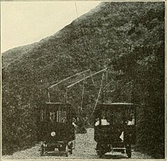
In 1910, Charles Mann and Richard Shoemaker built a "trackless trolley" line. This was a trolley bus system. It started carrying passengers on September 11. This was the first commercial trolley bus in the United States. It ran up Laurel Canyon Road. It went from the Pacific Electric Laurel Canyon Shuttle stop to a road house. This road house served visitors at the top of Lookout Mountain Road.
Each trolley car could hold 16 passengers. They had two trolley poles. One connected to a positive overhead wire, and one to a ground overhead wire. They could sway to either side of the street. They only used power when going uphill. These trolleys were actually Oldsmobile buses. Their gasoline engines were replaced with electric motors. Their open sides were enclosed in 1912. Around 1915, Stanley steam buses replaced them. The overhead wires were then removed. The shuttle service ran until 1918. It was stopped when not enough people used it. This happened after Pacific Electric stopped service to Laurel Canyon Boulevard in 1924.
On October 26, 1918, a fire destroyed about 200 acres (81 ha). It also completely burned down Lookout Mountain Inn. Strong Santa Ana winds helped the fire spread. Another big fire happened in July 1959. It destroyed about 38 homes. As the roads got better, people could access the area by car.
As of 2007, a vacant lot sits at 2401 Laurel Canyon Blvd. This is where the famous 1915 "Log Cabin" mansion once stood. It had an 80-foot (24 m) living room and a huge fireplace. It also had a bowling alley. Silent film star Tom Mix once lived there. Later, Frank Zappa rented it in 1968. The house burned down on Halloween in 1981. Across the street, at 2400 Laurel Canyon Blvd., was the home that magician Harry Houdini may have rented around 1919. It was originally the Walker estate.
The 1960s and 1970s Music Scene
Laurel Canyon became a center for counterculture in the mid-1960s and early 1970s. It became famous as the home for many rock musicians from Los Angeles. These included Cass Elliot of the Mamas & the Papas and Joni Mitchell. Other famous residents were Frank Zappa, Jim Morrison of The Doors, and Carole King. The bands The Byrds, Buffalo Springfield, and The Eagles also had members living there.
John Phillips of the Mamas & the Papas was inspired by his Laurel Canyon home. He wrote the song "Twelve Thirty (Young Girls Are Coming to the Canyon)" in 1967. The next year, blues artist John Mayall released his album Blues from Laurel Canyon. This album was based on his experiences while vacationing there.
The area and its residents inspired Joni Mitchell's album Ladies of the Canyon (1970). Her house was made famous in the Crosby, Stills, and Nash song "Our House" (1970). This song was written by Graham Nash. The group is said to have met and sung together for the first time in Mitchell's living room.
Rock photographer Henry Diltz also lived in Laurel Canyon. He used the beautiful canyon scenery for many of his photos. These photos captured the West Coast music scene of the 1960s and 1970s. Some of his pictures became album covers, like the one for CSN's first album Crosby, Stills & Nash.
Later Years of Music Influence
Musician Josh Tillman, known as Father John Misty, was partly inspired by moving to Laurel Canyon. His song "I Went to the Store One Day" tells how he met his wife, Emma. They met in the parking lot of the Laurel Canyon Country Store.


