
List of ultras of Mexico facts for kids

Mexico is home to many amazing mountains, and some of the most special are called ultra-prominent summits. These are mountains that stand out a lot from the land around them. To be "ultra-prominent," a mountain must rise at least 1,500 meters (about 4,921 feet) above the lowest point connecting it to a higher peak.
Scientists measure mountains in a few ways:
- Elevation: This is how high the mountain's top is above sea level. Think of it like how high an airplane flies!
- Prominence: This shows how much a mountain rises above the land right around its base. It tells you how much of a "bump" it is compared to its surroundings.
- Isolation: This measures how far a mountain is from any other peak that is just as tall or taller. It tells you how lonely a mountain is!
Mexico has 26 ultra-prominent summits. The tallest of these, Pico de Orizaba, rises over 4,000 meters (about 13,123 feet) in prominence! Popocatépetl is next, with over 3,000 meters (about 9,842 feet) of prominence. Nevado de Colima has over 2,500 meters (about 8,202 feet) of prominence.
Mexico's Ultra-Prominent Mountains
These 26 amazing mountains are found across many states in Mexico. For example, four are in Puebla, four in Oaxaca, and four in Nuevo León. Other states like México, Jalisco, Veracruz, Michoacán, Baja California Sur, Coahuila, Morelos, Guerrero, Baja California, Tlaxcala, and Querétaro each have some of these impressive peaks. Some of these mountains even sit right on the border between two states!
| Rank | Mountain Peak | State | Mountain Range | Elevation (meters) | Prominence (meters) | Location |
|---|---|---|---|---|---|---|
| 1 | Pico de Orizaba | Cordillera Neovolcanica | 5636 | 4922 | 19°01′50″N 97°16′11″W / 19.0305°N 97.2698°W | |
| 2 | Popocatépetl | Cordillera Neovolcanica | 5410 | 3040 | 19°01′21″N 98°37′40″W / 19.0225°N 98.6278°W | |
| 3 | Nevado de Colima | Cordillera Neovolcanica | 4270 | 2720 | 19°33′48″N 103°36′31″W / 19.5633°N 103.6087°W | |
| 4 | Nevado de Toluca | Cordillera Neovolcanica | 4690 | 2225 | 19°06′07″N 99°46′04″W / 19.1020°N 99.7677°W | |
| 5 | Cerro Teotepec | Sierra Madre del Sur | 3550 | 2180 | 17°28′06″N 100°08′11″W / 17.4682°N 100.1364°W | |
| 6 | Cerro el Nacimiento | Sierra Madre del Sur | 3710 | 2140 | 16°12′41″N 96°11′48″W / 16.2115°N 96.1967°W | |
| 7 | Picacho del Diablo | Sierra de San Pedro Mártir | 3095 | 2125 | 30°59′33″N 115°22′31″W / 30.9925°N 115.3753°W | |
| 8 | Sierra de Minas Viejas | Sierra Madre Oriental | 2710 | 1965 | 26°07′11″N 100°33′24″W / 26.1196°N 100.5568°W | |
| 9 | Cerro Las Conchas | Michoacán | 2890 | 1960 | 18°43′17″N 102°58′26″W / 18.7215°N 102.9740°W | |
| 10 | La Malinche | Cordillera Neovolcanica | 4430 | 1920 | 19°13′52″N 98°01′56″W / 19.2310°N 98.0321°W | |
| 11 | Sierra de la Laguna | Sierra de la Laguna | 2090 | 1920 | 23°32′21″N 109°57′15″W / 23.5392°N 109.9542°W | |
| 12 | Sierra la Madera | Mexican Plateau | 3030 | 1905 | 27°02′04″N 102°23′32″W / 27.0345°N 102.3922°W | |
| 13 | Cerro la Joya | Sierra Madre Oriental | 2950 | 1900 | 21°25′51″N 99°07′57″W / 21.4309°N 99.1326°W | |
| 14 | Cerro Potosí | Sierra Madre Oriental | 3720 | 1875 | 24°52′19″N 100°13′58″W / 24.8719°N 100.2327°W | |
| 15 | Volcán Tancítaro | Cordillera Neovolcanica | 3840 | 1665 | 19°25′00″N 102°19′11″W / 19.4166°N 102.3198°W | |
| 16 | Cerro El Centinela | Mexican Plateau | 3122 | 1657 | 25°08′09″N 103°13′49″W / 25.1359°N 103.2304°W | |
| 17 | Picacho San Onofre | Sierra Madre Oriental | 3550 | 1650 | 23°48′03″N 99°50′47″W / 23.8007°N 99.8464°W | |
| 18 | El Aguacate Oeste | Sierra Madre del Sur | 2830 | 1650 | 16°34′52″N 95°48′13″W / 16.5812°N 95.8035°W | |
| 19 | Tres Virgenes | Tres Virgenes | 1951 | 1626 | 27°28′12″N 112°35′31″W / 27.4700°N 112.5919°W | |
| 20 | Sierra de Santa Martha | Cordillera Neovolcanica | 1690 | 1620 | 18°20′44″N 94°51′27″W / 18.3455°N 94.8576°W | |
| 21 | Cerro las Capillas | Jalisco | 2890 | 1590 | 19°33′19″N 104°08′50″W / 19.5552°N 104.1472°W | |
| 22 | Cerro Zempoaltépetl | Sierra Madre de Oaxaca | 3420 | 1580 | 17°07′57″N 96°00′45″W / 17.1324°N 96.0125°W | |
| 23 | Iztaccihuatl | Cordillera Neovolcanica | 5230 | 1560 | 19°10′49″N 98°38′29″W / 19.1802°N 98.6415°W | |
| 24 | Tequila Volcano | Jalisco | 2930 | 1530 | 20°47′14″N 103°50′48″W / 20.7872°N 103.8468°W | |
| 25 | Cerro Atravesado | Oaxaca | 2310 | 1510 | 16°45′55″N 94°27′05″W / 16.7652°N 94.4514°W | |
| 26 | Sierra del Fraile | Sierra Madre Oriental | 2310 | 1510 | 25°51′52″N 100°36′34″W / 25.8645°N 100.6095°W |
Images for kids
-
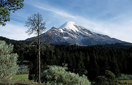
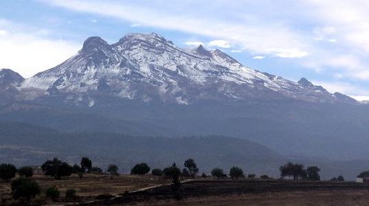
1. The top of Pico de Orizaba, a huge volcano on the border between Puebla and Veracruz, is the highest peak in Mexico.
-
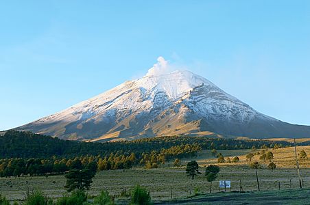
2. The top of Volcán Popocatépetl, a volcano where Puebla, México, and Morelos meet, is the second highest peak in Mexico.
-
3. Nevado de Colima is a volcano in Colima.
-
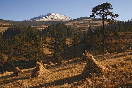
4. Nevado de Toluca is a volcano in México.
-
23. The top of Volcán Iztaccíhuatl, a volcano on the border between Puebla and México, is the third highest peak in Mexico.


See also
 In Spanish: Anexo:Ultraprominentes de México para niños
- List of mountain peaks of North America
- Mountain peaks of Canada
- List of mountain peaks of the United States
- Mountain peaks of México
- Extreme summits of México
- Mexico
- Geography of Mexico
- Category:Mountains of Mexico
- Geography of Mexico
- Physical geography
- Topography
- Mountain Elevation
- Mountain Prominence
- Mountain Isolation
- Topography
