
List of bridges to the Island of Montreal facts for kids
Montreal is a big city built on an island, so it needs many bridges and tunnels to connect it to other places. Imagine trying to get to school or a friend's house if you lived on an island and there were no bridges! Before bridges, people used boats or ferries to cross the water.
The city was founded way back in 1642, but the first way to cross by land didn't appear until 1847. That's when a wooden bridge was built over the Rivière des Prairies to Île Jésus (now part of Laval). This bridge was near where the Ahuntsic Bridge is today. Soon after, other bridges followed, making it easier to travel to and from Montreal.
When railroads became popular, Montreal got even more connections. In 1854, train bridges were built in Sainte-Anne-de-Bellevue, linking Montreal Island to Ontario and the Vaudreuil-Soulanges area. In 1860, the Victoria Bridge opened, connecting Montreal to the South Shore. This bridge was the longest in the world when it first opened!
Contents
Connecting Montreal: Bridges and Tunnels
Montreal Island is surrounded by three rivers: the St. Lawrence River, the Rivière des Prairies, and the Ottawa River. This means that to get on or off the island by land, you need to use a bridge or a tunnel.
This section lists the main bridges and tunnels that connect Montreal Island to other areas. They are listed as if you were traveling around the island in a circle, starting from the southwest and moving counter-clockwise. The year shown is for the bridge or tunnel that is currently there. If an older one was replaced, the original year is also noted.
| Key: Communities linked by individual bridges |
|---|
| (M): Montreal-side municipality and borough
(I): Island(s) crossed, if any (O): Opposite-side municipality and borough |
Bridges Over the St. Lawrence River
Crossing the Saint Lawrence River has always been a big challenge for engineers. The river is wide, deep, has strong currents, and can freeze in winter.
The Victoria Bridge, built in 1860 for trains, was about 2 kilometers (1.2 miles) long. It was the longest bridge in the world at the time! Later, in 1898, it was also opened for cars.
The Canadian Pacific Railway built its own train bridge, the Saint-Laurent Railway Bridge, in 1886. For this project, the Mohawk people of Kahnawake helped build the steel structure.
In the 1930s, the first bridges just for cars were built: the Jacques-Cartier and Mercier bridges. More bridges, like the Louis-Hippolyte Lafontaine Bridge–Tunnel and the original Champlain Bridge, were added in the 1960s.
For over 50 years, no new major crossings were built. Then, a brand new Samuel De Champlain Bridge was built. It cost billions of dollars and opened in 2019, replacing the older Champlain Bridge.
In the 1950s, the Saint Lawrence Seaway was built to allow large ships to travel inland. This project required big changes to all the bridges that existed back then.
| Span | Picture | First span built | Current span built | Communities linked | Carries | Name origin | Coordinates |
|---|---|---|---|---|---|---|---|
| Saint-Laurent Railway Bridge | .jpg) |
1886 | 1910 | (M) Borough of LaSalle | Canadian Pacific Railway (CPR) exo Candiac commuter train |
Named after the Saint Lawrence River | 45°25′8″N 73°39′34″W / 45.41889°N 73.65944°W |
| (O) Kahnawake Mohawk Reserve | |||||||
| Honoré Mercier Bridge |  |
— | 1934, 1963 | (M) Borough of LaSalle | Honoré Mercier (1840–1894), a former Premier of Quebec | 45°25′0″N 73°39′18″W / 45.41667°N 73.65500°W | |
| (O) Kahnawake Mohawk Reserve | |||||||
| Champlain Bridge Ice Structure |  |
— | 1964 | (M) Borough of Verdun | Route Verte 1 and 2 (bike paths) | Samuel de Champlain (c. 1580–1635), who founded Quebec City | 45°27′57″N 73°31′11″W / 45.46583°N 73.51972°W |
| (O) St. Lawrence Seaway levee (a raised bank) | |||||||
| Samuel De Champlain Bridge |  |
1962 | 2019 | (M) Borough of Verdun | Autoroutes 10, 15, and 20 |
45°28′7″N 73°31′15″W / 45.46861°N 73.52083°W | |
| (I) Île des Sœurs (exit) | |||||||
| (O) Brossard | |||||||
| Victoria Bridge |  |
1860 | 1898 | (M) Borough of Le Sud-Ouest | Canadian National Railway (CN) exo Mont-Saint-Hilaire commuter train Via Rail and Amtrak passenger trains |
Queen Victoria of the United Kingdom (1819–1901) | 45°29′29″N 73°31′46″W / 45.49139°N 73.52944°W |
| (O) Saint-Lambert | |||||||
| Pont de la Concorde and Pont des Îles |  |
— | 1965 | (M) Borough of Ville-Marie | Pierre-Dupuy Avenue and Route Verte 1 and 2 | Named after Montreal's motto, Concordia salus (meaning "well-being through harmony") | 45°30′22″N 73°32′17″W / 45.50611°N 73.53806°W (Pont de la Concorde) 45°30′28″N 73°31′49″W / 45.50778°N 73.53028°W (Pont des Îles) |
| (O) Île Sainte-Hélène and Île Notre-Dame (Parc Jean-Drapeau), borough of Ville-Marie, Montreal | |||||||
| Montreal Metro Tunnel |  |
— | 1966 | (M) Borough of Ville-Marie (Berri-UQAM station) | Line 4 Yellow (subway) | — | 45°30′N 73°32′W / 45.500°N 73.533°W |
| (I) Île Sainte-Hélène (Jean-Drapeau station) and Île Notre-Dame | |||||||
| (O) Longueuil, borough of Vieux-Longueuil (Longueuil–Université-de-Sherbrooke station) | |||||||
| Jacques Cartier Bridge |  |
— | 1930 | (M) Borough of Ville-Marie | Pedestrians and bicycles |
Jacques Cartier (1491–1557), a French explorer | 45°31′17″N 73°32′28″W / 45.52139°N 73.54111°W |
| (I) Île Sainte-Hélène (exit) and Île Notre-Dame | |||||||
| (O) Longueuil, borough of Vieux-Longueuil | |||||||
| Louis-Hippolyte Lafontaine Bridge–Tunnel |  |
— | 1967 | (M) Borough of Mercier–Hochelaga-Maisonneuve | Autoroute 25/Trans-Canada Highway |
Louis-Hippolyte Lafontaine (1807–1864), a former Prime Minister of the Province of Canada | 45°35′0″N 73°29′51″W / 45.58333°N 73.49750°W |
| (I) Île Charron (Îles de Boucherville) (exit) | |||||||
| (O) Longueuil, borough of Vieux-Longueuil |
Bridges Over the Rivière des Prairies
The Rivière des Prairies is smaller than the St. Lawrence, but it also needed bridges. The first wooden toll bridges were built in the 1840s to connect Montreal to Laval. Before that, people used ferries to cross the river.
The first train line across this river opened in 1876. The Bordeaux Railway Bridge is the oldest bridge still standing that connects Montreal to Laval over this river. In the 1960s and 1970s, many new highway bridges were built, and older ones like the Pie IX Bridge were updated for faster traffic.
| Span | Picture | First span built | Current span built | Communities linked | Carries | Name origin | Coordinates |
|---|---|---|---|---|---|---|---|
| Le Gardeur Bridge | .jpg) |
— | 1939 (widened 1975) | (M) Borough of Rivière-des-Prairies–Pointe-aux-Trembles | Pierre Le Gardeur de Repentigny (1605–1648), a French lord | 45°42′13″N 73°29′1″W / 45.70361°N 73.48361°W | |
| (I) Île Bourdon | |||||||
| (O) Repentigny | |||||||
| Laurier Railway Bridge | .jpg) |
— | 1904 | (M) Borough of Rivière-des-Prairies–Pointe-aux-Trembles | CN Via Rail exo Mascouche commuter train |
Wilfrid Laurier (1841–1919), a former Prime Minister of Canada | 45°42′10″N 73°29′8″W / 45.70278°N 73.48556°W |
| (I) Île Bourdon | |||||||
| (O) Charlemagne | |||||||
| Charles de Gaulle Bridge |  |
— | 1965 | (M) Borough of Rivière-des-Prairies–Pointe-aux-Trembles | Charles de Gaulle (1890–1970), a former President of France | 45°42′7″N 73°30′32″W / 45.70194°N 73.50889°W | |
| (O) Charlemagne | |||||||
| Olivier-Charbonneau Bridge |  |
— | 2011 | (M) Borough of Rivière-des-Prairies–Pointe-aux-Trembles | Olivier Charbonneau (c.1613-1687), the first European settler of Île Jésus | 45°38′16″N 73°37′14″W / 45.63778°N 73.62056°W | |
| (O) Laval (Saint-François) | |||||||
| Pie IX Bridge | .jpg) |
1937 | 1967 | (M) Borough of Montreal North | Pope Pius IX (1792–1878) | 45°35′57″N 73°38′49″W / 45.59917°N 73.64694°W | |
| (O) Laval (Saint-Vincent-de-Paul) | |||||||
| Centrale de la Rivière des Prairies | .jpg) |
— | 1930 | (M) Borough of Ahuntsic-Cartierville | Hydro-Québec (a power station) | Named after the Rivière des Prairies | 45°35′17″N 73°39′21″W / 45.58806°N 73.65583°W |
| (I) Île de la Visitation and Île du Cheval de Terre | |||||||
| (O) Laval (Duvernay) | |||||||
| Papineau-Leblanc Bridge |  |
— | 1969 | (M) Borough of Ahuntsic-Cartierville | Louis-Joseph Papineau (1786–1871), a leader of the Patriote movement Alpha Leblanc (1908–1962), a local landowner |
45°34′34″N 73°40′1″W / 45.57611°N 73.66694°W | |
| (I) Île de la Visitation | |||||||
| (O) Laval (Duvernay) | |||||||
| Viau Bridge (Ahuntsic Bridge) |  |
1847 | 1962 (widened 1993) | (M) Borough of Ahuntsic-Cartierville | Ahuntsic, a Huron boy who drowned in 1625. The origin of the name Viau is uncertain. | 45°33′26″N 73°40′32″W / 45.55722°N 73.67556°W | |
| (O) Laval (Pont-Viau) | |||||||
| Montreal Metro Tunnel |  |
— | 2007 | (M) Borough of Ahuntsic-Cartierville (Henri-Bourassa station) | Line 2 Orange (subway) | — | 45°33′N 73°40′W / 45.550°N 73.667°W |
| (O) Laval (Cartier station) | |||||||
| Bordeaux Railway Bridge |  |
— | 1876 | (M) Borough of Ahuntsic-Cartierville | CPR exo Saint-Jérôme commuter train Quebec Gatineau Railway Route Verte 1 and 2 |
Named after Bordeaux, a former town | 45°32′53″N 73°41′58″W / 45.54806°N 73.69944°W |
| (I) Île Perry | |||||||
| (O) Laval (Laval-des-Rapides) | |||||||
| Médéric Martin Bridge |  |
— | 1958 (widened 1991) | (M) Borough of Ahuntsic-Cartierville | Autoroute 15/Trans-Canada Highway |
Médéric Martin (1869–1946), a former Mayor of Montreal | 45°32′25″N 73°42′45″W / 45.54028°N 73.71250°W |
| (O) Laval (Laval-des-Rapides) | |||||||
| Lachapelle Bridge (Cartierville Bridge) |  |
1848 | 1930, 1975 | (M) Borough of Ahuntsic-Cartierville | Pascal Persillier-Lachapelle, who built the first bridge | 45°31′59″N 73°43′43″W / 45.53306°N 73.72861°W | |
| (O) Laval (Chomedey) | |||||||
| Louis Bisson Bridge | .jpg) |
— | 1975 | (M) Borough of Pierrefonds-Roxboro | Louis Bisson (1909–1997), a Canadian pilot | 45°30′42″N 73°45′54″W / 45.51167°N 73.76500°W | |
| (O) Laval (Chomedey / Sainte-Dorothée) | |||||||
| Île Bigras railway crossing |  |
— | 1916 | (M) Borough of Pierrefonds-Roxboro | CN (Used to be for the Deux-Montagnes commuter train, now being replaced by the Réseau express métropolitain) |
(no official name) | 45°30′59″N 73°50′52″W / 45.51639°N 73.84778°W |
| (I) (Île Bigras) Île-Bigras commuter train station |
|||||||
| (O) Laval (Sainte-Dorothée) | |||||||
| Jacques Bizard Bridge |  |
1893 | 1966 | (M) Sainte-Geneviève, Montreal, borough of L'Île-Bizard–Sainte-Geneviève | Boulevard Jacques Bizard | Jacques Bizard (1642–1692), a local landowner | 45°29′15″N 73°52′5″W / 45.48750°N 73.86806°W |
| (O) Île Bizard (Montreal, borough of L'Île-Bizard–Sainte-Geneviève) |
Bridges Over the Lake of Two Mountains and Ottawa River East Channel
The very first train bridge to Montreal Island was built over the Ottawa River East Channel in 1854. This bridge, along with another built at the same time over the West Channel, was the first permanent connection from Montreal to the mainland.
It wasn't until 1925 that a permanent road link was built across the Ottawa River from Montreal Island. This link included the Galipeault Bridge and Taschereau Bridge. Before the Île aux Tourtes Bridge was built, Île Perrot was the only way to drive west out of Montreal.
All three bridges across the Ottawa River East Channel have a twin bridge built at the same time across the West Channel.
| Span | Picture | First span built | Current span built | Communities linked | Carries | Name origin | Coordinates |
|---|---|---|---|---|---|---|---|
| Île aux Tourtes Bridge |  |
— | 1966 | (M) Senneville | Autoroute 40/Trans-Canada Highway |
Named after Île aux Tourtes (which means Wild Pigeon island) | 45°25′13″N 73°59′7″W / 45.42028°N 73.98528°W (Across Lake of Two Mountains) |
| (I) Île Girwood, Île aux Tourtes | |||||||
| (O) Vaudreuil-Dorion | |||||||
| Canadian Pacific Rail Bridge |  |
— | 1893 | (M) Sainte-Anne-de-Bellevue | CPR exo Vaudreuil-Hudson commuter train |
(no official names) | 45°24′12″N 73°57′24″W / 45.40333°N 73.95667°W (Across Canal Sainte-Anne) |
| (I) Île Bellevue | |||||||
| (O) Île Perrot | |||||||
| Canadian National Rail Bridge | .jpg) |
— | 1854 | (M) Sainte-Anne-de-Bellevue | CN Via Rail Canada passenger trains to Ottawa/Toronto |
45°24′12″N 73°57′24″W / 45.40333°N 73.95667°W (Across Canal Sainte-Anne) |
|
| (I) Île Bellevue | |||||||
| (O) Île Perrot | |||||||
| Galipeault Bridge |  |
1925 | 1991, 2009 | (M) Sainte-Anne-de-Bellevue | Antonin Galipeault (1879–1971), a Quebec politician | 45°24′10″N 73°57′21″W / 45.40278°N 73.95583°W (Across Canal Sainte-Anne) |
|
| (I) Île Bellevue | |||||||
| (O) Île Perrot |
Images for kids
-
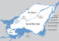
Bridges are needed to connect Montreal to the mainland (gray).

See also
- Crossings of the Canal de l'Aqueduc
- Crossings of the Lachine Canal
- List of crossings of the Ottawa River
- List of crossings of the Rivière des Mille Îles
- Rivière des Prairies
- List of crossings of the Rivière des Prairies
- List of crossings of the Saint Lawrence River
- List of hydroelectric stations in Quebec
- List of bridges in Canada
