
List of national monuments in County Kerry facts for kids
The Irish government has a special list of places and buildings in County Kerry that are super important to history. These places are called "national monuments." They are protected by the state so everyone can learn about them for many years to come! Sometimes, even the land around these monuments is protected to keep them safe.
Contents
Exploring Kerry's Ancient Sites
County Kerry is full of amazing historical sites. From old castles to mysterious stone forts, these places tell us stories about how people lived long, long ago in Ireland. Let's take a look at some of these incredible national monuments!
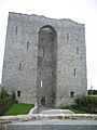
Mighty Castles
Castles were once strong homes and fortresses for important people. Many of Kerry's castles are now ruins, but they still look impressive!
- Ballymalis Castle is an old castle found in Ballymalis. It stands as a reminder of medieval times.
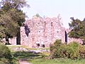
- Carrigafoyle Castle is a tall castle located near Ballylongford. It has a long history and was once a very important stronghold.
- Gallarus Castle is another cool castle in Baile na nGall. It's a tower house, which is a type of castle popular in Ireland.
- Listowel Castle in Listowel is a well-known castle with a distinctive look. It's a great example of Norman architecture.
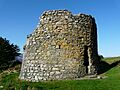
- Parkavonear Castle is a castle found in Parkavonear. It's a round tower, which is quite unique for a castle.
- Rahinnane Castle in Rahinnane is a castle built inside an old ringfort. It also has a souterrain, which is an underground passage.
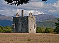
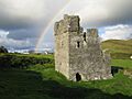
- Ross Castle is a famous castle located on Ross Island near Killarney. It sits right by the water and looks like something out of a fairy tale!
Ancient Churches and Abbeys
Many of Kerry's national monuments are old churches, cathedrals, and abbeys. These were important places for religious life and learning.
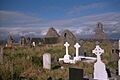
- Annagh Church is an old church in Annagh. It shows us how churches were built a long time ago.
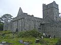
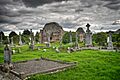
- Ardfert Cathedral in Ardfert is a large, historic cathedral. It also has two other churches nearby, making it a very important religious site.
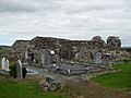
- Ardfert Abbey is a Franciscan friary in Ardfert. Friaries were homes for groups of monks called friars.
- Ballinskelligs Abbey is an Augustinian priory in Ballinskelligs. Priories were similar to abbeys, often housing monks or nuns.
- Ballywiheen has an early medieval church site and burial ground.
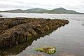
- Church Island (Valentia Harbour) and Church Island (Lough Currane) are both early medieval church sites located on islands. Imagine living and praying on a small island!
- Innisfallen Abbey is a beautiful abbey on Innisfallen Island. It includes a church and an oratory (a small chapel).
- Killelton Church in Killelton is another ancient church that has been preserved.
- Kilmalkedar is a very important early medieval church site. It has a church, an oratory, and other interesting features.
- Lislaughtin Abbey is a Franciscan friary in Lislaughtin.
- Muckross Abbey is a well-known Franciscan friary located in Killarney National Park. It's a beautiful ruin surrounded by nature.
- Aghadoe is an early medieval church site in Parkavonear. It has a very old and interesting doorway.
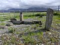
- Ratass Church in Ratass is an old church that also has an Ogham Stone.
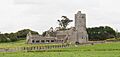
- Rattoo is an early medieval church site in Rattoo, famous for its round tower.
- Reask is an early medieval church site in Reask. It's known for its carved stone.
Mysterious Ogham Stones
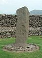
Ogham stones are ancient standing stones with a special kind of writing carved into their edges. This writing, called Ogham, is the earliest known form of writing in Ireland!
- Ardcanaght Stones are Ogham Stones found in Ardcanaght.
- Arraglen Ogham Stone is a single Ogham Stone in Arraglen.
- Ballintaggart Ogham Stones are a group of Ogham Stones in Ballintaggart.
- Ballybowler North Ogham Stone is an Ogham Stone in Ballybowler North.
- Cloghanecarhan has a ringfort and an Ogham Stone.
- Dunloe Ogham Stones are a collection of Ogham Stones in Coolmagort.
- Darrynane Beg Ogham Stone is an Ogham Stone in Derrynane.
- Emlagh East Ogham Stone is an Ogham Stone in Emlagh East.
- Kilcoolaght East ogham stones are Ogham Stones in Kilcoolaght East.
- Tullygarran ogham stones are two Ogham Stones in Tullygarran.
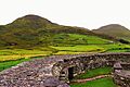
Strong Stone Forts
Stone forts, also known as cashels or ringforts, were circular enclosures made of stone. People lived inside them for protection.
- Caherconree Fort is an inland promontory fort in Caherconree. Promontory forts use natural features like cliffs for defense.
- Cathair na BhFionnúrach in Ballynavenooragh is a stone fort with huts and a souterrain.
- Cathair na gCat in Ballywiheen is a cashel that also has an Ogham Stone.
- Beginish house on Beginish Island is a stone-built house, showing how people lived in these structures.
- Caherdorgan North Cashel is a cashel in Caherdorgan North.
- Callanafersy (also known as Lisgortnageragh) is a ringfort in Callanafersy West.
- Cloghanecarhan is a ringfort with an Ogham Stone.
- Doonmore is a promontory fort in Doonsheane.
- Emlagh East Cashel is a cashel in Emlagh East.
- Dunbeg Fort is a famous promontory fort in Fahan.
- Glanfahan has several interesting sites, including clochauns (stone huts) and cashels like Caher Conor.
- Glin North has a clochán and a stone fort, as well as another cashel.
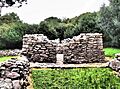
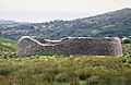
- Cahergall and Leacanabuaile are both cashels in Kimego West.
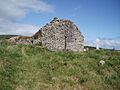
- Loher Cashel is a well-preserved cashel in Loher.
- Dún an Óir (Fort del Oro) is a promontory fort in Smerwick.
- Staigue is a very impressive cashel near Sneem, known for its strong, circular stone walls.
Other Interesting Sites
Kerry also has other unique national monuments that tell us about different aspects of ancient life.
- Gallaunmore is a standing stone in Ballineetig. Standing stones are ancient stones placed upright, often for unknown reasons.
- Ballinknockane has a burial ground and possible church, as well as hut sites and a souterrain.
- Teampall Geal (St. Manchan's Oratory) in Ballymorereagh is an early medieval church site with an Ogham Stone.
- Beenbane is a complex site with calluragh (old burial grounds), hut sites, cross slabs, enclosures, souterrains, and standing stones.
- Beginish house on Beginish Island is a stone-built house.
- Garfinny has a cemetery.
- Garfinny Bridge is an old bridge in Garfinny/Flemingstown.
- Rinn an Chaisleáin is a church site on Great Blasket Island.
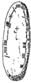
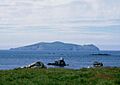
- Skellig Michael is an incredible early medieval church site on Great Skellig island. It's a UNESCO World Heritage site!
- Illauntannig, Inishtooskert, and Inishvickillane are all early medieval church sites on islands.
- Keelers' Stone in Kilmalkedar is a Bullaun Stone, which is a stone with bowl-shaped hollows, possibly used for grinding or rituals.
- St. Brendan's Oratory is a church in Kilmalkedar.
- Maumanorig is an early medieval church site.
- Illaunloughan is an early medieval church site in Portmagee.
- Reenconnell is an early medieval church site.
- Tonaknock Cross is an old cross in Tonaknock.
Images for kids
-
Annagh Church
-
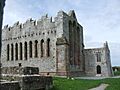
Ardfert Cathedral
-
Ardfert Friary
-
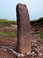
Arraglen Ogham Stone
-
Ballinskelligs Abbey
-
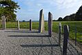
Ballintaggart Ogham Stones
-
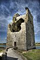
Ballymalis Castle
-
Ballywiheen Church Site
-
Beginish House
-
Caherconree Fort
-
Caherdorgan North Cashel
-
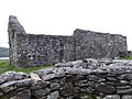
The Chancellor's House
-
Carrigafoyle Castle
-
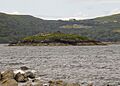
Church Island (Valentia Harbour)
-
Church Island (Lough Currane)
-
Dunloe Ogham Stones
-
Doonmore Promontory Fort
-
Dunbeg Fort
-
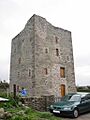
Gallarus Castle
-
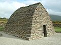
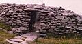
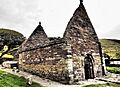
Gallarus Oratory
-
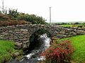
Garfinny Bridge
-
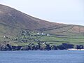
Rinn an Chaisleáin on Great Blasket Island
-
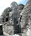
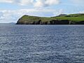
Skellig Michael
-
Inishtooskert
-
Innisfallen Abbey
-
Kilcoolaght East Ogham Stones
-
Killelton Church
-
Kilmalkedar Church
-
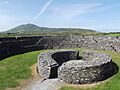
Cahergall Cashel
-
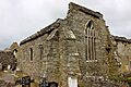
Lislaughtin Abbey
-
Listowel Castle
-
Loher Cashel
-
Muckross Abbey
-

Aghadoe Cathedral
-
Parkavonear Castle
-
Rahinnane Castle
-
Ratass Church
-
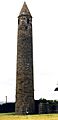
Rattoo Round Tower
-
Reask Stone
-
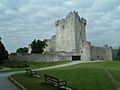
Ross Castle
-
Dún an Óir (Fort del Oro)
-
Staigue Stone Fort
-
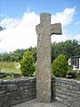
Tonaknock Cross
_looking_Northeast.JPG)


.jpg)

_-_geograph.org.uk_-_1392760.jpg)


,_The_Chancellor%27s_House_-_geograph.org.uk_-_275343.jpg)


.jpg)


