Logan County, Kansas facts for kids
Quick facts for kids
Logan County
|
|
|---|---|

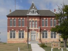
Butterfield Trail Museum, formerly the Logan County Courthouse, in Russell Springs (2014)
|
|

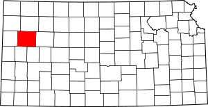
Location within the U.S. state of Kansas
|
|
 Kansas's location within the U.S. |
|
| Country | |
| State | |
| Founded | February 24, 1887 |
| Named for | John A. Logan |
| Seat | Oakley |
| Largest city | Oakley |
| Area | |
| • Total | 1,073 sq mi (2,780 km2) |
| • Land | 1,073 sq mi (2,780 km2) |
| • Water | 0.1 sq mi (0.3 km2) 0.01%% |
| Population
(2020)
|
|
| • Total | 2,762 |
| • Density | 2.6/sq mi (1.0/km2) |
| Time zone | UTC−6 (Central) |
| • Summer (DST) | UTC−5 (CDT) |
| Congressional district | 1st |
Logan County is a county in the state of Kansas, USA. Its main city and county seat is Oakley. In 2020, about 2,762 people lived there. The county got its name from John A. Logan, who was a general during the American Civil War.
One special place in Logan County is a mile-long area of Smoky Hill Chalk bluffs. These bluffs are about 100 feet (30 meters) tall. They are called "Little Jerusalem" because they look a bit like an ancient walled city. Most of this area used to be on private land. But in 2016, a group called The Nature Conservancy bought the land. Now, it's a public park called Little Jerusalem Badlands State Park, which opened in October 2019.
Contents
History of Logan County
Early Times in Kansas
For thousands of years, the Great Plains of North America were home to nomadic Native American tribes. These groups moved around, often following animal herds like bison.
From the 1500s to the 1700s, France claimed a lot of land in North America. After a war called the French and Indian War in 1762, France secretly gave a large area, including parts of what is now Kansas, to Spain. This was part of a deal called the Treaty of Fontainebleau.
The 1800s and County Creation
In 1802, Spain gave most of this land back to France. Then, in 1803, the United States bought a huge amount of land from France. This was called the Louisiana Purchase. It included most of modern-day Kansas. The U.S. paid about 2.83 cents per acre for this land.
In 1854, the Kansas Territory was set up. Then, in 1861, Kansas officially became the 34th U.S. state. Logan County itself was created in 1887.
Before it was called Logan County, this area was first named St. John County in 1871. It was formed from a part of Wallace County. The Kansas State Legislature decided to change the name from St. John to Logan in 1885.
Geography and Location
Logan County covers about 1,073 square miles (2,779 square kilometers). Almost all of this area is land, with only a tiny bit of water.
Main Roads and Highways
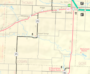
Several important roads run through Logan County, making it easy to travel around. These include:
 Kansas Highway 25
 U.S. Highway 40
 U.S. Highway 83
 Interstate 70
Neighboring Counties
Logan County shares its borders with several other counties:
- Thomas County to the north
- Gove County to the east
- Scott County to the southeast
- Wichita County to the south
- Wallace County to the west (this border is also where the time zone changes to Mountain Time)
- Sherman County to the northwest (this border also marks the Mountain Time zone)
Population and People
| Historical population | |||
|---|---|---|---|
| Census | Pop. | %± | |
| 1890 | 3,384 | — | |
| 1900 | 1,962 | −42.0% | |
| 1910 | 4,240 | 116.1% | |
| 1920 | 3,223 | −24.0% | |
| 1930 | 4,145 | 28.6% | |
| 1940 | 3,688 | −11.0% | |
| 1950 | 4,206 | 14.0% | |
| 1960 | 4,036 | −4.0% | |
| 1970 | 3,814 | −5.5% | |
| 1980 | 3,478 | −8.8% | |
| 1990 | 3,081 | −11.4% | |
| 2000 | 3,046 | −1.1% | |
| 2010 | 2,756 | −9.5% | |
| 2020 | 2,762 | 0.2% | |
| 2023 (est.) | 2,665 | −3.3% | |
| U.S. Decennial Census 1790-1960 1900-1990 1990-2000 2010-2020 |
|||
In 2000, there were 3,046 people living in Logan County. There were 1,243 households, which are groups of people living together. About 29.5% of these households had children under 18. Most households (59.3%) were married couples.
The average age of people in Logan County in 2000 was 41 years old. About 25.4% of the population was under 18.
Education in Logan County
Students in Logan County attend schools in different school districts. These districts help manage the schools and provide education.
School Districts
- Oakley USD 274
- Triplains USD 275
Communities and Towns
Logan County has several cities and smaller communities. Some communities are "unincorporated," meaning they don't have their own local government like a city does. There are also some "ghost towns," which are places where people used to live but are now mostly empty.
Cities in Logan County
- Oakley‡ (This is the county seat, where the main government offices are.)
- Russell Springs
- Winona
Smaller Communities (Unincorporated)
Ghost Towns
- McAllaster
- Sheridan
Townships
Logan County is divided into 11 smaller areas called townships. These townships help organize the county. The populations listed for each township include any cities or communities within them.
| Township | Population center |
Population | Land area km2 (sq mi) |
Geographic coordinates |
|---|---|---|---|---|
| Augustine | 26 | 187 (72) | 38°44′14″N 101°21′15″W / 38.73722°N 101.35417°W | |
| Elkader | 15 | 278 (107) | 38°53′33″N 100°52′1″W / 38.89250°N 100.86694°W | |
| Lees | 17 | 185 (72) | 38°44′26″N 100°59′5″W / 38.74056°N 100.98472°W | |
| Logansport | 14 | 278 (107) | 38°51′29″N 101°4′9″W / 38.85806°N 101.06917°W | |
| McAllaster | 29 | 276 (106) | 39°2′58″N 101°22′4″W / 39.04944°N 101.36778°W | |
| Monument | 144 | 276 (107) | 39°4′17″N 101°2′42″W / 39.07139°N 101.04500°W | |
| Oakley | Oakley | 2,343 | 278 (107) | 39°6′43″N 100°51′32″W / 39.11194°N 100.85889°W |
| Paxton | 24 | 186 (72) | 38°44′38″N 101°7′57″W / 38.74389°N 101.13250°W | |
| Russell Springs | 71 | 279 (108) | 38°53′16″N 101°12′15″W / 38.88778°N 101.20417°W | |
| Western | 44 | 279 (108) | 38°54′3″N 101°24′37″W / 38.90083°N 101.41028°W | |
| Winona | Winona | 319 | 277 (107) | 39°3′53″N 101°12′54″W / 39.06472°N 101.21500°W |
See also
 In Spanish: Condado de Logan (Kansas) para niños


