
Louisa County, Virginia facts for kids
Quick facts for kids
Louisa County
|
|||||
|---|---|---|---|---|---|
,_Louisa_(Louisa_County,_Virginia).jpg)
Louisa County Courthouse
|
|||||
|
|||||

Location within the U.S. state of Virginia
|
|||||
 Virginia's location within the U.S. |
|||||
| Country | |||||
| State | |||||
| Founded | 1742 | ||||
| Named for | Louise of Great Britain | ||||
| Seat | Louisa | ||||
| Largest town | Louisa | ||||
| Area | |||||
| • Total | 511 sq mi (1,320 km2) | ||||
| • Land | 496 sq mi (1,280 km2) | ||||
| • Water | 15 sq mi (40 km2) 2.9% | ||||
| Population
(2020)
|
|||||
| • Total | 37,596 | ||||
| • Density | 73.57/sq mi (28.407/km2) | ||||
| Time zone | UTC−5 (Eastern) | ||||
| • Summer (DST) | UTC−4 (EDT) | ||||
| Congressional district | 5th | ||||


Louisa County is a county in the state of Virginia. In 2020, about 37,596 people lived there. The main town and county seat is also called Louisa.
Contents
History of Louisa County
Before European settlers arrived, the area of Louisa County was home to several indigenous peoples. These included the Tutelo, Monacan, and Manahoac tribes. They later moved to join the Cayuga Iroquois people in New York. This happened because of pressure from English settlers.
Louisa County was created in 1742. It was formed from parts of Hanover County. The county got its name from Princess Louise of Great Britain. She was the youngest daughter of King George II. She was also the wife of King Frederick V of Denmark.
Patrick Henry, a famous American patriot, lived in Louisa County for a while in 1764. He was learning from Thomas Johnson, who represented Louisa County in the House of Burgesses. In 1765, Patrick Henry was elected to represent Louisa County himself. This was the start of his important political career.
The Virginia Central Railroad was built through Louisa County between 1838 and 1840. During the Civil War, this railroad was very important. It helped supply the Confederate armies. Because of this, some big cavalry battles happened in the county. One famous battle was at Trevilians in 1864.
Modern Times in Louisa County
The Twin Oaks Community started in 1967. It is one of the oldest communes in the country. A commune is a group of people who live together and share resources. This was part of a movement where young people wanted to live simpler lives. Louisa County is also home to the Acorn Community. This community was founded in 1993. It is a rural, cooperative group that shares income. Another new community, the Living Energy Farm, started in 2011. It aims to use no fossil fuels and embrace new solar technologies.
Lake Anna is a large artificial lake covering about 13,000 acres (53 square kilometers). It was built in the 1970s along with the North Anna Nuclear Generating Station. In recent years, more people have moved to Louisa County. Many retirees settle near Lake Anna. Also, its location is good for commuters. It is less than an hour's drive from cities like Richmond, Fredericksburg, and Charlottesville.

The 2011 Earthquake
On August 23, 2011, a magnitude 5.8 earthquake hit Virginia. It happened at 1:51 PM EST. The earthquake was centered in Louisa County, about 5 miles (8 km) southwest of Mineral. It was felt all along the East Coast of the United States. It was even felt in parts of Canada.
The earthquake caused a lot of damage in Louisa County. The total damage was over $70 million.
- Public school buildings had about $57.5 million in damage.
- Homes had about $11.5 million in damage.
- Churches had about $400,000 in damage.
- Businesses had about $400,000 in damage.
- Government buildings had about $500,000 in damage.
Geography of Louisa County
Louisa County has a total area of about 511 square miles (1,320 square kilometers). Of this, 496 square miles (1,280 square kilometers) is land. The remaining 15 square miles (39 square kilometers) is water.
Neighboring Counties
Louisa County shares borders with these other counties:
- Orange County – to the north
- Spotsylvania County – to the northeast
- Hanover County – to the east
- Goochland County – to the south
- Fluvanna County – to the southwest
- Albemarle County – to the west
Main Roads
Several important highways pass through Louisa County:
 I-64
I-64 US 15
US 15 US 33
US 33 US 250
 US 522
 SR 22
SR 22 SR 208
 SR 231
Population of Louisa County
| Historical population | |||
|---|---|---|---|
| Census | Pop. | %± | |
| 1790 | 8,467 | — | |
| 1800 | 11,892 | 40.5% | |
| 1810 | 11,900 | 0.1% | |
| 1820 | 13,746 | 15.5% | |
| 1830 | 16,151 | 17.5% | |
| 1840 | 15,433 | −4.4% | |
| 1850 | 16,691 | 8.2% | |
| 1860 | 16,701 | 0.1% | |
| 1870 | 16,332 | −2.2% | |
| 1880 | 18,942 | 16.0% | |
| 1890 | 16,997 | −10.3% | |
| 1900 | 16,517 | −2.8% | |
| 1910 | 16,578 | 0.4% | |
| 1920 | 17,089 | 3.1% | |
| 1930 | 14,309 | −16.3% | |
| 1940 | 13,665 | −4.5% | |
| 1950 | 12,826 | −6.1% | |
| 1960 | 12,959 | 1.0% | |
| 1970 | 14,004 | 8.1% | |
| 1980 | 17,825 | 27.3% | |
| 1990 | 20,325 | 14.0% | |
| 2000 | 25,627 | 26.1% | |
| 2010 | 33,153 | 29.4% | |
| 2020 | 37,596 | 13.4% | |
| 2021 (est.) | 38,848 | 17.2% | |
| U.S. Decennial Census 1790–1960 1900–1990 1990–2000 2010 2020 |
|||
2020 Census Data
The 2020 census showed how the population of Louisa County is made up. Most people are White, but there are also many Black or African American residents. The county is also home to people of Native American, Asian, Pacific Islander, and mixed backgrounds. A smaller group of people identify as Hispanic or Latino.
| Race / Ethnicity (NH = Non-Hispanic) | Pop 2010 | Pop 2020 | % 2010 | % 2020 |
|---|---|---|---|---|
| White alone (NH) | 25,562 | 28,535 | 77.10% | 75.90% |
| Black or African American alone (NH) | 5,832 | 5,365 | 17.59% | 14.27% |
| Native American or Alaska Native alone (NH) | 106 | 93 | 0.32% | 0.25% |
| Asian alone (NH) | 158 | 251 | 0.48% | 0.67% |
| Pacific Islander alone (NH) | 15 | 18 | 0.05% | 0.05% |
| Some Other Race alone (NH) | 41 | 155 | 0.12% | 0.41% |
| Mixed Race or Multi-Racial (NH) | 677 | 1,814 | 2.04% | 4.82% |
| Hispanic or Latino (any race) | 762 | 1,365 | 2.30% | 3.63% |
| Total | 33,153 | 37,596 | 100.00% | 100.00% |
Communities in Louisa County
Towns
Census-designated place
Other Unincorporated Communities
- Apple Grove
- Bumpass
- Cuckoo
- Ferncliff
- Gum Spring
- Holly Grove
- Orchid
- Twin Oaks Community
- Trevilians
- Yanceyville
- Zion Crossroads
Historical Places and Points of Interest
- Green Springs Historic District
- Jerdone Castle
- Lake Anna
- Twin Oaks Community, a group of people who live and work together, is in Louisa County.
- Acorn Community, another community that shares income. They run the Southern Exposure Seed Exchange business.
Notable People from Louisa County
- James Waddel Alexander (1804–1859), a minister and professor at Princeton Theological Seminary.
- Arthur P. Bagby (1794–1858), the tenth Governor of Alabama.
- Henry "Box" Brown (c.1816–after 1889), a slave who famously escaped by mailing himself in a wooden crate.
- Paxus Calta (b. 1957), an activist and member of the Twin Oaks Community.
- Dabney Carr (1743–1773), a well-known patriot from Louisa County.
- Patrick Henry (1736–1799), a key figure in the American Revolution. He lived in Louisa County from 1765 to 1768.
- Charles W. Kent (1860–1917), an English scholar.
- Charles Henry Langston (1817–1892), an abolitionist and activist.
- John Mercer Langston (1829–1899), an abolitionist, educator, and politician. He was the first Black person elected to public office in Ohio. He also became the first Black person elected to the United States Congress from Virginia.
- Flora Molton (1908–1990), a singer.
- John Overton (1766–1833), a political leader and co-founder of Memphis, Tennessee.
- James Waddel (1739–1805), a famous Presbyterian preacher.
Images for kids
-
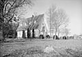
St. John's Chapel, near Boswells Tavern, Louisa County.
-
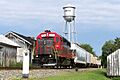
A local train of the Buckingham Branch railroad passes the C&O Depot and water tower in Louisa.


See also
 In Spanish: Condado de Louisa (Virginia) para niños
