
Loving County, Texas facts for kids
Quick facts for kids
Loving County
|
||
|---|---|---|

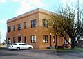
Loving County Courthouse, the only two-story building in Mentone, is listed in the National Register of Historic Places
|
||
|
||

Location within the U.S. state of Texas
|
||
 Texas's location within the U.S. |
||
| Country | ||
| State | ||
| Founded | February 26, 1887 | |
| Named for | Oliver Loving | |
| Seat | Mentone | |
| Largest community | Mentone | |
| Area | ||
| • Total | 677 sq mi (1,750 km2) | |
| • Land | 669 sq mi (1,732 km2) | |
| • Water | 7.8 sq mi (20 km2) 1.1% | |
| Population
(2020)
|
||
| • Total | 64 | |
| • Estimate
(2023)
|
43 |
|
| • Density | 0.064/sq mi (0.025/km2) | |
| Time zone | UTC−6 (Central) | |
| • Summer (DST) | UTC−5 (CDT) | |
| Congressional district | 23rd | |

Loving County is a special place in Texas, USA. It is known for having the smallest population of any county in the entire United States. In 2020, only 64 people lived there!
The county's main town and government center is Mentone. Loving County was first created in 1887. It later rejoined Reeves County for a while. Then, in 1931, it became its own county again. It is located in West Texas, near the border with New Mexico.
Contents
History of Loving County
Early Times and Explorers
Long ago, nomadic hunters lived in the area. These groups moved around to find food. In 1583, a traveler named Antonio de Espejo explored the region. He crossed the Pecos River during his journey.
Later, in the 1840s, people used a special river crossing. It was called Pope's Crossing. This spot helped them travel through the area. In 1854, John Pope surveyed the land. He was looking for a good path to build a railroad.
Pope set up a camp in 1855. He tried to drill for water three times. He only found water once, but could not reach it. In 1858, he was told to stop drilling. Soldiers stayed at Pope's camp from 1858 to 1861. The Butterfield Overland Mail route also passed through this area. This was a famous mail and passenger service.
Naming the County
The county is named after Oliver Loving. He was a famous cattle driver. In 1866, Loving and Charles Goodnight moved cattle through the area. They created the famous Goodnight–Loving Trail.
Sadly, in 1867, Oliver Loving was shot by a Comanche native. He died from his injury. The area was part of Bexar County for many years. Then it became part of Tom Green County.
In 1887, Loving County was officially created. This happened after eleven people asked the Texas Legislature for it. The new county was connected to Reeves County for some legal matters.
Mentone and Early Challenges
In 1893, six men from Denver arrived. They started the Loving Canal and Irrigation Company. They also founded the town of Mentone. A French surveyor named Mentone after his hometown in Menton, France.
The men gathered 150 signatures. They asked for the county to be officially organized. This was approved in June. An election was held in July, with 83 voters. Mentone became the county seat.
However, there were problems with these early elections. Many believed they were not fair. The county planned to build a courthouse. But a flood destroyed their irrigation project. By 1897, all county officials had left. Loving County was dissolved and returned to Reeves County.
A Cowboy's Grave and Oil Discovery
Loving County does not have a cemetery. There is only one known grave in the area. It belongs to Shady Davis, a 21-year-old cowboy. He was killed by his horse in the 1920s. He was buried about 12 miles from Mentone.
The population of the area grew when oil was discovered. This led to the creation of a town called Ramsey. In 1931, Loving County was organized again. It is the only county in Texas to be organized twice! Ramsey was later renamed Mentone.
In 2020, during the COVID-19 pandemic, Loving County was the last county in the main United States to report a COVID-19 case. Three cases were confirmed there.

Geography of Loving County
Loving County is about three-fifths the size of Rhode Island. It covers about 677 square miles (1,750 square kilometers). Only a small part of this area, about 1.1%, is covered by water.
Water and Landscape
Water is very important in Loving County. The groundwater here has a lot of gypsum. This makes it hard to use. So, water often has to be brought in from towns like Kermit or Pecos, Texas. The Pecos River used to be a water source. But its water became too salty.
The Pecos River forms the western border of the county. It also creates the Red Bluff Reservoir. This reservoir is on the border with Reeves County and Eddy County, New Mexico.
The land in Loving County is mostly flat desert. There are a few small hills. You can find desert shrubs, grasses, and cacti here. Along the river, there are salt cedar trees. The land ranges from about 2,686 to 3,311 feet (819 to 1,009 meters) above sea level. Loving County is the smallest county by area in the Permian Basin region.
Main Roads
 State Highway 302
 Ranch to Market Road 652
Neighboring Counties
- Lea County, New Mexico (north)
- Winkler County (east)
- Ward County (southeast)
- Reeves County (southwest)
- Eddy County, New Mexico (northwest)
Communities in Loving County
Towns and Settlements
- Mentone (This is the county seat, where the government offices are.)
Old Ghost Towns
- Hay Flat (mostly in Winkler County)
- Porterville
- Woody
People of Loving County (Demographics)
| Historical population | |||
|---|---|---|---|
| Census | Pop. | %± | |
| 1890 | 3 | — | |
| 1900 | 33 | 1,000.0% | |
| 1910 | 249 | 654.5% | |
| 1920 | 82 | −67.1% | |
| 1930 | 195 | 137.8% | |
| 1940 | 285 | 46.2% | |
| 1950 | 227 | −20.4% | |
| 1960 | 226 | −0.4% | |
| 1970 | 164 | −27.4% | |
| 1980 | 91 | −44.5% | |
| 1990 | 107 | 17.6% | |
| 2000 | 67 | −37.4% | |
| 2010 | 82 | 22.4% | |
| 2020 | 64 | −22.0% | |
| 2023 (est.) | 43 | −47.6% | |
| U.S. Decennial Census 1850–2010 2010–2020 |
|||
Population in 2020
In 2020, the census counted 64 people living in Loving County. There were 25 households and 18 families. The county is very spread out, with only about 0.1 people per square mile. There were 34 homes in total.
Most of the people in the county (87.5%) were White. About 1.6% were Native American. About 1.6% were from other races. And 9.4% were from two or more races. A small number, 1.56%, were Hispanic or Latino.
About 30.2% of residents were under 18 years old. Only 2.3% were under 5 years old. No residents were 65 or older.
Loving County has the smallest population of any county in the United States. In 2023, the estimated population was even lower, at 43 people. It is also one of the least densely populated counties. This means there are very few people living in a large area.
From 2018 to 2022, the average household income in Loving County was very high. It was about $141,373. This is much higher than the national average. This is partly because of the small population and oil money.
Population in 2010
In 2010, the census showed 82 people living in the county. There were 39 households and 20 families. The population density was still very low.
Most people (79.3%) were White. About 4.9% were Native American. About 8.5% were from other races. And 7.3% were from two or more races. About 21.95% of the population was Hispanic or Latino.
Economy of Loving County
Loving County's economy is mostly based on a few key things. These are oil and gas production, ranching, and county services.
Ranching and Oil
In 1887, there were three cattle businesses in the county. They owned many cattle, worth a lot of money. By 1900, the value of livestock was very high.
The Toyah-Bell Oil Company started in 1921. It was the first company to produce oil in the county. Oil production reached its highest point in 1931. Over 1.2 million barrels of oil were produced that year.
Wealth and Taxes
In 1970, Loving County had a small part of Texas's total wealth. At that time, there was no unemployment. No residents were receiving welfare.
However, in 1986, the county had a very high unemployment rate. It was 29.7%. The Texas Almanac reported that there were 15 ranches in the county. These ranches were very large, often over 23,000 acres. They were also worth a lot of money.
Loving County has one of the highest average incomes per person in the United States. This is because of the money from oil. In 1983, the average income per person was $32,505. This was much higher than the national average of $9,496. In 1986, taxes from oil and gas companies made up 99% of the county's tax money.
Education in Loving County
Schools in Loving County never received money from the federal government, as of 1970. The schools were also still separated by race.
In 1970, the elementary school had 30 students and three teachers. The 17 high school students went to school in Winkler County. The elementary school in Mentone closed in 1978. It only had two students and two teachers left. The county decided to join the Wink-Loving Independent School District. Today, students in Loving County attend schools in the Wink-Loving Independent School District. They can also attend Odessa College.
Images for kids
-
Loving County Courthouse, the only two-story building in Mentone, is listed in the National Register of Historic Places
See also
 In Spanish: Condado de Loving para niños
