
Maipo (river) facts for kids
Quick facts for kids Maipo |
|
| River | |
 The Maipo river
|
|
| Country | Chile |
|---|---|
| Regions | Santiago Metropolitan Region, Valparaíso |
| Provinces | Cordillera, Maipo, Talagante, Melipilla, San Antonio |
| Comunas | San José de Maipo, Puente Alto, Buin, Melipilla, San Antonio |
| Tributaries | |
| - left | Clarillo |
| - right | Yeso, Colorado, Mapocho |
| City | Melipilla |
| Source | Los Nacimientos |
| - location | Maipo volcano, Cordillera province, Chile |
| - elevation | 3,135 m (10,285 ft) |
| - coordinates | 34°13′50″S 69°51′20″W / 34.23056°S 69.85556°W |
| Mouth | Pacific Ocean |
| - location | Llolleo, San Antonio province, Valparaíso, Chile |
| - elevation | 0 m (0 ft) |
| - coordinates | 33°36′40″S 71°37′50″W / 33.61111°S 71.63056°W |
| Length | 250 km (155 mi) |
| Basin | 15,304 km² (5,909 sq mi) |
| Discharge | for La Obra |
| - average | 92.3 m³/s (3,260 cu ft/s) |
The Maipo River is an important river in central Chile. It flows from the Andes mountains, past the capital city of Santiago, and finally reaches the Pacific Ocean.
It's one of Chile's main rivers. It provides water for farms (this is called irrigation) and drinking water for many people in the area.
Contents
River Journey: Where the Maipo Flows
The Maipo River is about 250 km (155 mi) long. The area of land that drains into the river (its drainage basin) is about 15,304 km2 (5,909 sq mi).
Starting Point: High in the Andes
The Maipo River begins high up in the Andes mountains. Its source is called Los Nacimientos (which means "The Birthplaces"). This spot is on the side of the Maipo volcano in the San José de Maipo area. It starts at a high point, about 3,135 m (10,285 ft) above sea level.
From its start, the river flows towards the northwest through a deep valley called the Cajón del Maipo. Along the way, two rivers, the El Volcán and Yeso rivers, join the Maipo from the right side, near the town of San Gabriel. After passing the city of San José de Maipo, the Colorado river also joins the Maipo from the right. Then, the Maipo River turns and flows towards the southwest.
Journey Through the Valley
After flowing for about 110 km (68 mi), the Maipo River leaves the Andes mountains. This happens south of Puente Alto, where the river is still about 800 m (2,625 ft) above sea level. Here, it enters the wide Maipo valley. Near Talagante, after flowing close to the city of Santiago, another river called the Mapocho joins the Maipo from the right side.
Reaching the Pacific Ocean
The Maipo River then crosses through the coastal mountains. It finally reaches the town of Llolleo, which is just south of the port city of San Antonio. This is where the Maipo River flows into the Pacific Ocean.
Main Rivers Joining the Maipo
Many smaller rivers flow into the Maipo River. These are called tributaries.
|
Left-side tributaries:
|
Right-side tributaries:
|
How People Use the Maipo River
The Maipo River is very useful to the people of Chile.
Energy and Fun
In the upper parts of the river, the water is used to create hydroelectricity. This is a way to make electricity using the power of flowing water.
The Cajón del Maipo area is also a popular place for tourists. Many people visit to enjoy water sports like rafting on the river.
Farming and Wine
In the Maipo valley, the river's water helps grow grapes. Because of this, the valley is a very important region for making wine.
Images for kids
-
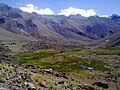
Los Nacimientos, the place where the Maipo River begins its journey.
-
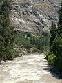
The Maipo River flowing through the Cajón del Maipo canyon.
-
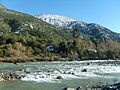
A view of the Maipo River.
-
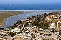
The mouth of the Maipo River in Llolleo, where it meets the Pacific Ocean.


Related pages
