Milam County, Texas facts for kids
Quick facts for kids
Milam County
|
|
|---|---|

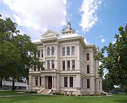
The Milam County Courthouse in Cameron. The Courthouse was added to the National Register of Historic Places on December 20, 1977.
|
|

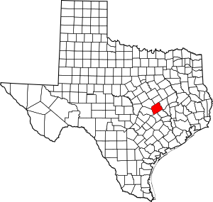
Location within the U.S. state of Texas
|
|
 Texas's location within the U.S. |
|
| Country | |
| State | |
| Founded | 1837 |
| Named for | Benjamin Rush Milam |
| Seat | Cameron |
| Largest city | Rockdale |
| Area | |
| • Total | 1,022 sq mi (2,650 km2) |
| • Land | 1,017 sq mi (2,630 km2) |
| • Water | 4.8 sq mi (12 km2) 0.5% |
| Population
(2020)
|
|
| • Total | 24,754 |
| • Density | 24.221/sq mi (9.352/km2) |
| Time zone | UTC−6 (Central) |
| • Summer (DST) | UTC−5 (CDT) |
| Congressional district | 17th |
Milam County is a special area in the state of Texas. It's called a county. In 2020, about 24,754 people lived there. The main town, or county seat, is Cameron.
Milam County was first set up in 1834 when Texas was part of Mexico. It became a county in 1837. The county is named after Benjamin Rush Milam. He was an early settler and a soldier who fought in the Texas Revolution.
Contents
Milam County's Location and Size
Milam County is located in central Texas. The U.S. Census Bureau says the county covers a total area of about 1,022 square miles. Most of this area, about 1,017 square miles, is land. The rest, about 4.8 square miles, is water. This means only a small part (0.5%) of the county is covered by water.
Main Roads in Milam County
Several important roads help people travel through Milam County. These roads connect the county to other parts of Texas.
Neighboring Counties Around Milam
Milam County shares its borders with six other counties. These are its neighbors:
- Falls County (to the north)
- Robertson County (to the northeast)
- Burleson County (to the southeast)
- Lee County (to the south)
- Williamson County (to the southwest)
- Bell County (to the northwest)
Who Lives in Milam County?
This section talks about the people living in Milam County. It looks at how many people live there and what groups they belong to. This information comes from a special count called the census. The census happens every ten years.
| Historical population | |||
|---|---|---|---|
| Census | Pop. | %± | |
| 1850 | 2,907 | — | |
| 1860 | 5,175 | 78.0% | |
| 1870 | 8,984 | 73.6% | |
| 1880 | 18,659 | 107.7% | |
| 1890 | 24,773 | 32.8% | |
| 1900 | 39,666 | 60.1% | |
| 1910 | 36,780 | −7.3% | |
| 1920 | 38,104 | 3.6% | |
| 1930 | 37,915 | −0.5% | |
| 1940 | 33,120 | −12.6% | |
| 1950 | 23,585 | −28.8% | |
| 1960 | 22,263 | −5.6% | |
| 1970 | 20,028 | −10.0% | |
| 1980 | 22,732 | 13.5% | |
| 1990 | 22,946 | 0.9% | |
| 2000 | 24,238 | 5.6% | |
| 2010 | 24,757 | 2.1% | |
| 2020 | 24,754 | 0.0% | |
| Race / Ethnicity (NH = Non-Hispanic) | Pop 2000 | Pop 2010 | Pop 2020 | % 2000 | % 2010 | % 2020 |
|---|---|---|---|---|---|---|
| White alone (NH) | 16,763 | 16,216 | 15,367 | 69.16% | 65.50% | 62.08% |
| Black or African American alone (NH) | 2,627 | 2,380 | 2,097 | 10.84% | 9.61% | 8.47% |
| Native American or Alaska Native alone (NH) | 85 | 76 | 67 | 0.35% | 0.31% | 0.27% |
| Asian alone (NH) | 49 | 95 | 111 | 0.20% | 0.38% | 0.45% |
| Pacific Islander alone (NH) | 2 | 0 | 11 | 0.01% | 0.00% | 0.04% |
| Other Race alone (NH) | 22 | 10 | 84 | 0.09% | 0.04% | 0.34% |
| Mixed Race or Multiracial (NH) | 174 | 200 | 753 | 0.72% | 0.81% | 3.04% |
| Hispanic or Latino (any race) | 4,516 | 5,780 | 6,264 | 18.63% | 23.35% | 25.31% |
| Total | 24,238 | 24,757 | 24,754 | 100.00% | 100.00% | 100.00% |
In 2000, there were 24,238 people living in Milam County. Most people (about 78.89%) were White. About 11.05% were African American. About 18.63% of the people were of Hispanic or Latino background.
Many households (about 32.40%) had children under 18. Most households (56.50%) were married couples. The average household had about 2.59 people. The average family had about 3.11 people.
The median age in the county was 38 years old. This means half the people were younger than 38 and half were older. About 27.50% of the people were under 18. About 17.20% were 65 or older.
The median income for a household was $33,186. This is the middle income for all households. About 15.90% of the population lived below the poverty line.
Learning and Schools in Milam County
Milam County has many schools for its students. There are six main school districts that serve the area.
Independent School Districts
- Buckholts Independent School District
- Cameron Independent School District
- Gause Independent School District
- Milano Independent School District
- Rockdale Independent School District
- Thorndale Independent School District
Some other school districts also reach into Milam County. These include districts from nearby counties:
- Bartlett
- Caldwell
- Holland
- Lexington
- Rosebud-Lott
There is also a private school called St. Paul Lutheran School St. Paul Lutheran Church and School, Thorndale in Thorndale. It teaches students from pre-kindergarten up to 8th grade.
For higher education, students in most of Milam County can attend Temple Junior College District. Students in some parts of the county can go to Blinn College.
Towns and Communities
Milam County has several towns and communities. These range from larger cities to smaller, unincorporated areas. Some places are even "ghost towns," meaning they are no longer inhabited.
Cities in Milam County
- Cameron (This is the main town, also called the county seat)
- Milano
- Rockdale
- Thorndale (A small part of this city is in a different county, Williamson County)
Towns in Milam County
Census-Designated Places
These are areas that are like towns but are not officially incorporated as cities or towns.
- Ben Arnold
- Burlington
- Gause
- Praesel
Smaller Communities (Unincorporated)
These are even smaller places that don't have their own local government.
- Baileyville
- Belmena
- Branchville
- Clarkson
- Corinth
- Cross Roads
- Davilla
- Detmold
- Elevation
- Elm Ridge
- Forest Grove
- Hanover
- Hoyte
- Jones Prairie
- Liberty
- Liberty Hill
- Marak
- Marlow
- Maysfield
- Minerva
- Pettibone
- San Gabriel
- Sharp
- Silver City
- Val Verde
- Yarrellton
Ghost Towns
These are places that used to be communities but are now mostly empty or abandoned.
See also
 In Spanish: Condado de Milam para niños
 | Sharif Bey |
 | Hale Woodruff |
 | Richmond Barthé |
 | Purvis Young |


