
Williamson County, Texas facts for kids
Quick facts for kids
Williamson County
|
|||
|---|---|---|---|
.jpg)
The Williamson County Courthouse in 2019
|
|||
|
|||

Location within the U.S. state of Texas
|
|||
 Texas's location within the U.S. |
|||
| Country | |||
| State | |||
| Founded | March 13, 1848 | ||
| Named for | Robert McAlpin Williamson | ||
| Seat | Georgetown | ||
| Largest city | Round Rock | ||
| Area | |||
| • Total | 1,134 sq mi (2,940 km2) | ||
| • Land | 1,118 sq mi (2,900 km2) | ||
| • Water | 16 sq mi (40 km2) 1.4% | ||
| Population
(2020)
|
|||
| • Total | 609,017 | ||
| • Estimate
(2023)
|
697,191 |
||
| • Density | 378/sq mi (146/km2) | ||
| Time zone | UTC−6 (Central) | ||
| • Summer (DST) | UTC−5 (CDT) | ||
| Congressional districts | 10th, 17th, 31st, 37th | ||


Williamson County, often called "Wilco," is a county in the state of Texas. In 2020, about 609,017 people lived here. The main city and county seat is Georgetown. The county is named after Robert McAlpin Williamson, a local leader and hero from the Battle of San Jacinto.
Williamson County is part of the larger Austin-Round Rock-San Marcos area. It was even named one of the "Best Cities to Live in" in 2009. The county is in Central Texas. It has two main types of land: the rocky Edwards Plateau in the west and the rich, flat Texas Blackland Prairies in the east. Interstate 35 generally divides these two areas.
Contents
- History of Williamson County
- Geography and Nature
- Population Information
- Sun City Texas Community
- Economy and Jobs
- Williamson County Courthouse
- County Flag
- Education in Williamson County
- Local Media
- Transportation Routes
- Communities in Williamson County
- Famous People from Williamson County
- Images for kids
- See also
History of Williamson County
Ancient Times: Early People

People have lived in Williamson County for at least 11,200 years. The first known people lived during the Ice Age. Evidence of the Clovis culture from around 9,200 BC has been found nearby.
A very important discovery was the ancient bones called "Leanderthal Lady." These bones were found by accident by road workers near Leander, Texas. Scientists have studied the site for many years. They found that the bones are about 10,500 years old.
Old campsites are also found along streams like Brushy Creek and the San Gabriel River. These sites often have old tools and relics.
The first Native American groups known in the area were the Tonkawa. They were hunters who followed buffalo. Later, they learned to ride horses and use firearms. The Comanches also raided settlements in the county until the 1860s. Other groups like the Kiowa and Tawakoni also lived here when the first settlers arrived.
Thrall Flood of 1921
In September 1921, a big hurricane caused heavy rains over Williamson County. The storm stayed over Thrall, a small town in the east. It dropped almost 40 inches of rain in 36 hours.
The amount of rain in 24 hours in Thrall (38.2 inches) is still the national record! This huge flood caused many deaths. Eighty-seven people drowned near Taylor, and 93 in Williamson County. This was one of the deadliest floods in Texas history, with 215 total deaths.
1997 Tornado Outbreak
On May 27, 1997, Williamson County was hit by its worst tornado outbreak ever. Twenty tornadoes struck, including an F-5 tornado. This F-5 tornado was the strongest type and the only one to hit Williamson County.
It killed 27 people and destroyed the Double Creek Estates neighborhood in Jarrell, Texas. Another strong tornado, an F-3, hit Cedar Park, killing one person. The tornadoes caused over $190 million in damage and 30 deaths in total.
Modern Growth and Development
Williamson County has grown very fast because it is just north of Austin. Austin has also been expanding north. Most of the growth has been new homes. But big companies like Dell have also moved here. This means people can now live and work in the same area.
The county has become a busy place with many shops and businesses. Large shopping centers like the Premium Outlet Mall and IKEA have opened in Round Rock. New hospitals and colleges have also opened since 2015. New toll roads like North Loop 1 and Texas State Highway 45 have made it easier to travel to Austin.
Geography and Nature
Williamson County covers about 1,134 square miles. Most of it is land (1,118 square miles), with 16 square miles of water.
The county is split into two parts by the Balcones Escarpment. This line runs from north to south through Jarrell, Georgetown, and Round Rock.
- The western half is part of the Texas Hill Country. It has hills, rocky land, and many Texas live oak trees and prickly pear cactus.
- The eastern half is flatter and part of the Coastal Plains. It has dark, rich soil that is good for farming. But this area is quickly being developed as more people move in.
The San Gabriel River flows through the center and south of the county. It is the county's only river.
Land Features
The eastern part of Williamson County is flat prairie land. It has rich, dark clay soils. This area is still used for farming cotton and other crops, and for raising cattle.
West of the Balcones Escarpment is the start of the "upland" Texas Hill Country. This area has rocky land with thin soil over limestone. It has rolling hills, nice views, hardwood trees, and lots of wildlife. Rainwater here soaks into the ground and helps fill the Edwards Aquifer. Because of this, there are rules about building here to protect the environment and endangered species.
Interstate 35, the county's main highway, runs along the line that divides these two different land areas.
Protected Natural Areas
The Balcones Canyonlands National Wildlife Refuge is in the Texas Hill Country. It includes parts of western Williamson County. This refuge was created in 1992 to protect two endangered songbirds: the golden-cheeked warbler and the black-capped vireo. It also protects the Hill Country habitat for other animals. Some parts of the refuge, like Berry Springs Park, are open to visitors.
Endangered Animals
Williamson County is home to five endangered species. Two are songbirds protected in the Balcones Canyonlands Preserve. The other three are tiny creatures that live only in the cave-like cracks and holes in the limestone on the west side of the county. This type of rocky land is called Karst topography.
To protect these species, a group of landowners and developers worked together. They helped create a plan to save enough caves with endangered species. This plan allows property owners to help protect these animals by donating land.
Neighboring Counties
- Bell County (north)
- Milam County (northeast)
- Lee County (southeast)
- Bastrop County (southeast)
- Travis County (south)
- Burnet County (west)
Population Information
| Historical population | |||
|---|---|---|---|
| Census | Pop. | %± | |
| 1850 | 1,568 | — | |
| 1860 | 4,529 | 188.8% | |
| 1870 | 6,368 | 40.6% | |
| 1880 | 15,155 | 138.0% | |
| 1890 | 25,909 | 71.0% | |
| 1900 | 38,072 | 46.9% | |
| 1910 | 42,228 | 10.9% | |
| 1920 | 42,934 | 1.7% | |
| 1930 | 44,146 | 2.8% | |
| 1940 | 41,698 | −5.5% | |
| 1950 | 38,853 | −6.8% | |
| 1960 | 35,044 | −9.8% | |
| 1970 | 37,305 | 6.5% | |
| 1980 | 76,521 | 105.1% | |
| 1990 | 139,551 | 82.4% | |
| 2000 | 249,967 | 79.1% | |
| 2010 | 422,679 | 69.1% | |
| 2020 | 609,017 | 44.1% | |
| 2023 (est.) | 697,191 | 64.9% | |
| U.S. Decennial Census 1850–2010 2010–2020 |
|||
| Race / Ethnicity (NH = Non-Hispanic) | Pop 2000 | Pop 2010 | Pop 2020 | % 2000 | % 2010 | % 2020 |
|---|---|---|---|---|---|---|
| White alone (NH) | 183,847 | 269,481 | 336,410 | 73.55% | 63.76% | 55.24% |
| Black or African American alone (NH) | 12,444 | 24,744 | 38,557 | 4.98% | 5.85% | 6.33% |
| Native American or Alaska Native alone (NH) | 759 | 1,340 | 1,659 | 0.30% | 0.32% | 0.27% |
| Asian alone (NH) | 6,483 | 20,084 | 53,982 | 2.59% | 4.75% | 8.86% |
| Pacific Islander alone (NH) | 161 | 354 | 592 | 0.06% | 0.08% | 0.10% |
| Other race alone (NH) | 230 | 661 | 3,124 | 0.09% | 0.16% | 0.51% |
| Mixed race or Multiracial (NH) | 3,053 | 7,981 | 27,605 | 1.22% | 1.89% | 4.53% |
| Hispanic or Latino (any race) | 42,990 | 98,034 | 147,088 | 17.20% | 23.19% | 24.15% |
| Total | 249,967 | 422,679 | 609,017 | 100.00% | 100.00% | 100.00% |
| Municipal Population History | ||||||||||
|---|---|---|---|---|---|---|---|---|---|---|
| # | Largest Cities in Williamson County | 1950 | 1960 | 1970 | 1980 | 1990 | 2000 | 2010 | 2020 | 2022 (estimate) |
| 1 | Round Rock | 1,438 | 1,878 | 2,811 | 11,812 | 30,923 | 61,136 | 99,887 | 119,468 | 126,697 |
| 2 | Georgetown | 4,951 | 5,218 | 6,395 | 9,468 | 14,842 | 28,339 | 47,400 | 67,176 | 86,507 |
| 3 | Cedar Park | 202 | 385 | 692 | 3,474 | 5,161 | 26,049 | 48,937 | 77,595 | 77,642 |
| 4 | Leander | – | – | – | 2,179 | 3,398 | 7,596 | 26,521 | 59,202 | 74,375 |
| 5 | Hutto | 529 | 400 | 545 | 659 | 630 | 1,250 | 14,698 | 27,577 | 36,655 |
| 6 | Taylor | 9,071 | 9,434 | 9,616 | 10,619 | 11,472 | 13,575 | 15,191 | 16,267 | 16,975 |
| 7 | Liberty Hill | – | – | – | – | – | 1,409 | 967 | 3,646 | 9,099 |
| Williamson County total | 38,853 | 35,044 | 37,305 | 76,521 | 139,551 | 249,967 | 422,679 | 609,017 | 671,418 | |
2010 Census Facts
In 2010, Williamson County had 422,679 people. There were 152,606 homes and 111,514 families. The population density was about 373 people per square mile.
- About 80.9% of people were White.
- About 7.1% were African American.
- About 5.8% were Asian.
- About 23.2% of the population was Hispanic or Latino.
About 39.1% of homes had children under 18. The average household had 2.74 people. The average family had 3.20 people. The median age was 34 years old.
The median income for a household was $60,642. For a family, it was $66,208. About 4.8% of the population lived below the poverty line.
Sun City Texas Community

One big reason for Williamson County's growth is the Sun City community in Georgetown. It opened in 1995 and is for people aged 55 and older.
Sun City Texas is a large community, about 5,300 acres. It has mostly single-family homes and duplexes. The community also has three golf courses. Most residents move there from other parts of Texas to stay close to their families.
When it was first planned, some people worried about its size. They also worried about how it would affect Georgetown as a family town. However, the community has generally been welcomed. In 2008, two Sun City residents even ran for mayor of Georgetown.
Economy and Jobs

Farming History
For most of the 1800s and early 1900s, Williamson County was mainly a farming area. Cotton was the most important crop between the 1880s and 1920s. Williamson County was the top cotton producer in Texas.
Two national railroads helped transport cotton bales. The towns of Taylor became a main center for cotton production. Other farming and dairy activities also took place in the eastern part of the county. Ranching was common in the western Hill Country.
Today, farming and ranching are still important in some areas. Cotton is still grown eastward toward Hutto and Taylor.
Businesses and Employers
Dell Computer in Round Rock used to be the largest employer, with about 16,000 workers. Now, retail stores and healthcare are major employers. This includes hospitals like St. David's and Seton Medical Center Williamson.
Big retail centers like the IKEA store and Premium Outlet Mall in Round Rock are important for the county. Wolf Ranch and The Rivery in Georgetown are also major shopping areas.
Higher education also helps the county's economy. The Texas State University Round Rock Campus and the Austin Community College campus offer two-year degrees and training.
Williamson County Courthouse
The current courthouse was built in 1911. It is a beautiful example of Neoclassical Revival style. Over the years, it went through many changes. In 1966, some of its original features were even removed.
But with help from the Texas Historical Commission, the courthouse was restored. In 2006-2007, it was returned to its original 1911 look. It is now a proud symbol of the county once again.
County Flag
The stars on the Williamson County flag represent 33 communities. These communities were identified in a 1973 book. In 1970, these communities ranged from small groups of 20 people to towns with over 10,000 residents.
Today, it's hard to say exactly how many communities exist. But in 2004, Williamson County had 11 towns with over 1,000 people. Seven towns had populations over 5,000.
Education in Williamson County
School Districts
Many school districts serve Williamson County. Some of these districts also cover parts of other counties.
- Bartlett ISD
- Burnet Consolidated ISD
- Coupland ISD
- Florence ISD
- Georgetown ISD
- Granger ISD
- Hutto ISD
- Jarrell ISD
- Leander ISD
- Liberty Hill ISD
- Pflugerville ISD
- Round Rock ISD
- Taylor ISD
- Thrall ISD
Colleges and Universities
Williamson County also has several places for higher education:
- Southwestern University (Georgetown)
- Texas State University Round Rock Campus
- Texas A&M Health Science Center (Round Rock)
- National American University (Georgetown)
- Temple College (Hutto and Taylor)
Austin Community College (ACC) serves most of the county. ACC has campuses in Round Rock, Cedar Park, and Leander. The Round Rock campus is the largest ACC campus. It offers two-year degrees and training in areas like high-tech and nursing.
Local Media
Newspapers that serve Williamson County include:
- Round Rock Leader
- Williamson County Sun (Georgetown)
- Taylor Press
- Hutto News
- Hill Country News (Leander)
- Liberty Hill Independent
- Tribune-Progress (Bartlett)
- Community Impact Newspaper (founded in 2005)
- The Austin American-Statesman also covers news in Williamson County.
Transportation Routes
Major Highways
|
Other Important Roads
|
Communities in Williamson County
Cities in Multiple Counties
- Austin (mostly in Travis County)
- Bartlett (partly in Bell County)
- Cedar Park (small part in Travis County)
- Leander (partly in Travis County)
- Pflugerville (mostly in Travis County)
- Round Rock (small part in Travis County)
- Thorndale (mostly in Milam County)
Cities Only in Williamson County
- Coupland
- Florence
- Georgetown (county seat)
- Granger
- Hutto
- Jarrell
- Liberty Hill
- Taylor
- Thrall
- Weir
Census-Designated Places
These are areas that are like towns but are not officially incorporated as cities.
- Brushy Creek
- Santa Rita Ranch
- Serenada
- Sonterra
Unincorporated Communities
These are smaller communities that are not part of any city.
Ghost Towns
Famous People from Williamson County

- Sam Bass (1851–1878) was an outlaw. He was killed in a famous shootout in Round Rock in 1878. This event is re-enacted every year.
- King Fisher (1854–1884) was a Texas rancher. He lived in Williamson County when he was a boy.
- Dan Moody, from Taylor, was the Governor of Texas from 1927 to 1931. He worked to make changes and was known for being against the Ku Klux Klan.
- Nolan Ryan is a famous retired baseball pitcher. He played for 27 seasons and is in the Baseball Hall of Fame.
- Paul Wall, a well-known rapper, was born in Georgetown.
Images for kids
-
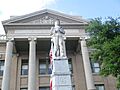
A statue at the Williamson County courthouse
-
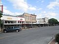
A part of Courthouse Square in Georgetown
-
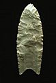
This Clovis point is from about 11,200 years ago.
-
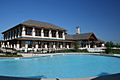
A pool at one of the Sun City Texas recreation centers
-

Cotton bolls ready for harvest
-
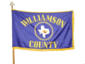
Williamson County flag
-
The original Chainsaw Massacre movie house was moved in 1993 and restored to become a restaurant in Kingsland
See also
 In Spanish: Condado de Williamson (Texas) para niños
