
Bastrop County, Texas facts for kids
Quick facts for kids
Bastrop County
|
|
|---|---|

The Bastrop County Courthouse in Bastrop is designed in classical revival style. Built in 1883, the Courthouse and Jail Complex were listed in the National Register of Historic Places on November 20, 1975.
|
|

Location within the U.S. state of Texas
|
|
 Texas's location within the U.S. |
|
| Country | |
| State | |
| Founded | 1837 |
| Named for | Felipe Enrique Neri, Baron de Bastrop |
| Seat | Bastrop |
| Largest city | Elgin |
| Area | |
| • Total | 896 sq mi (2,320 km2) |
| • Land | 888 sq mi (2,300 km2) |
| • Water | 7.4 sq mi (19 km2) 0.8% |
| Population
(2020)
|
|
| • Total | 97,216 |
| • Density | 108.50/sq mi (41.892/km2) |
| Time zone | UTC−6 (Central) |
| • Summer (DST) | UTC−5 (CDT) |
| Congressional districts | 10th, 27th |
Bastrop County is a county located in the U.S. state of Texas. It is found in Central Texas. The main city and county seat is Bastrop.
In 2020, about 97,216 people lived here. Bastrop County is part of the larger Austin–Round Rock area.
Contents
History of Bastrop County
In 1834, a group of lawmakers in Mexico created the area called Mina. This area included parts of many counties we know today.
On December 14, 1837, the leaders of the Republic of Texas changed the borders. They created Fayette County. On December 18, 1837, the county and town of Mina were renamed. They became Bastrop to honor Felipe Enrique Neri, Baron de Bastrop. He was an early Dutch settler who helped Stephen F. Austin get land in Texas.
Over the next few years, the county's borders changed a few more times. By 1850, Bastrop County was almost the size it is today.
In September 2011, Bastrop County had a very large wildfire. It was the most damaging wildfire in Texas history. It sadly destroyed over 1,600 homes.
Geography of Bastrop County
Bastrop County covers a total area of about 896 square miles. Most of this area, about 888 square miles, is land. Only a small part, about 7.4 square miles, is water.
Neighboring Counties
Bastrop County shares its borders with these other counties:
- Williamson County (to the north)
- Lee County (to the northeast)
- Fayette County (to the southeast)
- Caldwell County (to the southwest)
- Travis County (to the northwest)
People of Bastrop County
| Historical population | |||
|---|---|---|---|
| Census | Pop. | %± | |
| 1850 | 3,099 | — | |
| 1860 | 7,006 | 126.1% | |
| 1870 | 12,209 | 74.3% | |
| 1880 | 17,215 | 41.0% | |
| 1890 | 20,736 | 20.5% | |
| 1900 | 26,845 | 29.5% | |
| 1910 | 25,344 | −5.6% | |
| 1920 | 26,649 | 5.1% | |
| 1930 | 23,888 | −10.4% | |
| 1940 | 21,610 | −9.5% | |
| 1950 | 19,622 | −9.2% | |
| 1960 | 16,925 | −13.7% | |
| 1970 | 17,297 | 2.2% | |
| 1980 | 24,726 | 42.9% | |
| 1990 | 38,263 | 54.7% | |
| 2000 | 57,733 | 50.9% | |
| 2010 | 74,171 | 28.5% | |
| 2020 | 97,216 | 31.1% | |
| 2023 (est.) | 110,778 | 49.4% | |
| U.S. Decennial Census 1850–2010 2010 2020 |
|||
| Race / Ethnicity (NH = Non-Hispanic) | Pop 2000 | Pop 2010 | Pop 2020 | % 2000 | % 2010 | % 2020 |
|---|---|---|---|---|---|---|
| White alone (NH) | 37,764 | 42,446 | 45,751 | 65.41% | 57.23% | 47.06% |
| Black or African American alone (NH) | 4,938 | 5,535 | 5,460 | 8.55% | 7.46% | 5.62% |
| Native American or Alaska Native alone (NH) | 239 | 315 | 312 | 0.41% | 0.42% | 0.32% |
| Asian alone (NH) | 255 | 449 | 718 | 0.44% | 0.61% | 0.74% |
| Pacific Islander alone (NH) | 22 | 54 | 63 | 0.04% | 0.07% | 0.06% |
| Other Race alone (NH) | 39 | 115 | 417 | 0.07% | 0.16% | 0.43% |
| Mixed Race or Multiracial (NH) | 631 | 1,067 | 3,011 | 1.09% | 1.44% | 3.10% |
| Hispanic or Latino (any race) | 13,845 | 24,190 | 41,484 | 23.98% | 32.61% | 42.67% |
| Total | 57,733 | 74,171 | 97,216 | 100.00% | 100.00% | 100.00% |
In 2000, there were 57,733 people living in Bastrop County. There were 20,097 households. About 14,771 of these were families. The county had about 65 people per square mile.
About 35.9% of households had children under 18. Most households (58.5%) were married couples. About 21.5% of households were single people. The average household had 2.77 people.
The population was spread out by age. About 28% were under 18. About 10.3% were 65 or older. The average age was 35 years.
The average income for a household was $43,578. For a family, it was $49,456. About 11.6% of the people lived below the poverty line. This included 15.4% of those under 18.
Education in Bastrop County
Several school districts serve the students of Bastrop County:
- Bastrop Independent School District
- Elgin Independent School District (part of it)
- Lexington Independent School District (part of it)
- McDade Independent School District
- Smithville Independent School District (part of it)
Austin Community College is the main community college for most of the county. Some areas are part of the Blinn Junior College District.
Transportation in Bastrop County
A new airport, Central Texas Airport, has been suggested. It would be about ten miles northwest of Bastrop town.
Main Highways
These are the major roads that go through Bastrop County:
 U.S. Highway 290
 State Highway 21
 State Highway 71
 State Highway 95
 State Highway 304
Fun Places to Visit
Bastrop County has some great places for outdoor activities:
Communities in Bastrop County
Cities
- Bastrop (This is the county seat, where the main government offices are)
- Elgin (Part of this city is also in Travis County)
- Mustang Ridge (Mostly in Travis County and a small part in Caldwell County)
- Smithville
Census-Designated Places
These are areas that are like towns but are not officially incorporated as cities:
Unincorporated Communities
These are smaller communities that are not part of any city:
Images for kids
-

Closeup view of the Bastrop County Courthouse, located across from the Roman Catholic Church in Bastrop
-
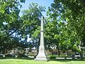
Obelisk commemorating Bastrop County soldiers in the army of the Confederate States of America is located on the courthouse grounds
-
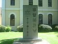
Veterans Memorial at Bastrop County Courthouse
-
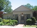
The Bastrop County Historical Museum in Bastrop periodically changes its exhibits


See also
 In Spanish: Condado de Bastrop para niños
