
Mount Konocti facts for kids
Quick facts for kids Mount Konocti |
|
|---|---|

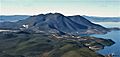
Mount Konocti as seen from Clear Lake
|
|
| Highest point | |
| Elevation | 4,305 ft (1,312 m) NAVD 88 |
| Prominence | 2,339 ft (713 m) |
| Geography | |
| Location | Lake County, California |
| Parent range | California Coast Ranges |
| Topo map | USGS Kelseyville |
| Geology | |
| Age of rock | About 350,000 years |
| Mountain type | Lava dome |
| Volcanic field | Clear Lake Volcanic Field |
| Last eruption | 11,000 years ago |
Mount Konocti is a large volcano located in Lake County, California, right on the southern edge of Clear Lake. It stands tall at about 4,305 feet (1,312 meters).
Mount Konocti is the second highest peak in the Clear Lake Volcanic Field. This area has many different volcanic hills and domes. Even though some people might call Mount Konocti "extinct," it is actually classified as having a High Threat Potential. This means it could erupt again in the future. However, the Clear Lake Volcanic Field is currently at a Normal alert level.
Contents
Where is Mount Konocti?
Mount Konocti is a very easy-to-spot landmark in Lake County, California. It is located between the towns of Lakeport and Clearlake. You can find it just south of Soda Bay and Riviera Heights. It is also east of Kelseyville. Places like Konocti Harbor and Soda Bay are right at the base of the mountain.
From the top of Mount Konocti, you can see the taller peaks and ridges around Snow Mountain East to the northeast.
Mount Konocti's Peaks
Mount Konocti has five main peaks. These are Wright Peak (about 4,299 feet or 1,310 meters), Howard Peak (about 4,286 feet or 1,306 meters), and South Peak (also about 4,286 feet or 1,306 meters). These three make up the main part of the mountain.
The other two peaks are Buckingham Peak (about 3,967 feet or 1,209 meters) and Clark Peak (about 2,880 feet or 878 meters). These are a bit separate from the main group. Konocti Road goes about 4 miles (6.4 km) west from Kelseyville. It winds between Howard and South Peaks and ends at Wright Peak, which is the very top of the mountain.
The History of Mount Konocti
Mount Konocti likely first erupted around 350,000 years ago. Its last eruption happened about 11,000 years ago. This volcano has had powerful eruptions in the past. About 13,000 years ago, huge lava flows created mountains from Clearlake Oaks to Ukiah. These old lava flows are now covered by trees and are hard to see.
Clear Lake itself is much older than the volcano. It might be the oldest lake in North America that we can accurately date. Scientists from the U.S. Geological Survey took samples from the lakebed in the 1970s and 1980s. These samples showed the lake is at least 480,000 years old.
Native American History
Archaeologists have found signs that native people have lived around Mount Konocti for as long as 11,000 years. The main groups were the Pomo people and the Wappo. The name "Konocti" comes from the Pomo language. It means "kno" (mountain) and "htai" (woman).
Plants and Trees
The mountain is covered with thick chaparral plants. This is similar to the maquis shrubland found in Europe. You can also find many Oak trees, Pacific madrone trees, manzanita, and western white pine. These are all common plants in the California coastal mountains.
On the northeast side of Mount Konocti, there is a very steep and heavily forested area. Local people call it the "Black Forest." This is because it never gets direct sunlight. The Black Forest has many tall Douglas fir trees.
Mysterious Caves
People in the area have known for a long time that Mount Konocti has many natural caves. Most of these natural caves were filled in or collapsed for safety reasons in the early 1900s. However, many locals still believe that the volcano's central magma chamber is a huge, empty space. They think it might be partly filled with water from Clear Lake and connected to the lake by an underground passage. This cavern could be the biggest on Earth. But it's hard to prove it exists because the volcano's structure is unstable and eroding. Also, thick plants hide the cave entrances. No one has made an accurate map of the caves because of the dense plants and unstable hillsides.
Most of Mount Konocti used to be owned by private people. They did not want people exploring or studying the mountain. But the County of Lake bought 1,520 acres on top of the mountain in 2009. Because of this, the Mount Konocti County Park opened to the public on September 24, 2011.
A Pomo legend tells a story from around 1818. After a long dry period, the water level of Clear Lake dropped very low. This showed a cave on the eastern side of Konocti that no one had seen before. A group of Pomo men went into the cave and found a huge underground lake with "blind fish." Divers have tried many times to find this cave again, but they haven't been successful.
Is Mount Konocti Active?
The U.S. Geological Survey studies volcanoes. They classify the Clear Lake Volcanic Field, which includes Mount Konocti, as having a High Threat Potential. This means it is a volcano that scientists watch closely.
Images for kids
-
Aerial view from the southeast, around 1975

