
Mount Melbourne facts for kids
Quick facts for kids Mount Melbourne |
|
|---|---|

Mount Melbourne seen from the ice-covered Ross Sea
|
|
| Highest point | |
| Elevation | 2,730 m (8,960 ft) |
| Prominence | 1,699 m (5,574 ft) |
| Listing | Ultra |
| Geography | |

Mount Melbourne
Location in Antarctica
|
|
| Geology | |
| Age of rock | Unknown |
| Mountain type | Stratovolcano |
| Volcanic belt | McMurdo Volcanic Group |
| Last eruption | 1892 ± 30 years |
Mount Melbourne is a huge, ice-covered volcano in Antarctica. It stands 2,733-metre-high (8,967 ft) in Victoria Land, between Wood Bay and Terra Nova Bay. This volcano is shaped like a tall cone with a large, ice-filled crater at its top, called a caldera. Many smaller vents, called parasitic vents, are also found on its sides. A whole volcanic field surrounds Mount Melbourne.
The volcano is made up of tephra (volcanic ash and rock pieces) and lava flows. Scientists have found tephra buried in the ice, which helped them figure out that Mount Melbourne's last big eruption was around 1892. Today, the volcano is considered inactive.
Mount Melbourne is part of the McMurdo Volcanic Group, a chain of volcanoes in Antarctica. Its eruptions are linked to the West Antarctic Rift, a giant crack in the Earth's crust. The rocks from Mount Melbourne are mostly trachyandesite and trachyte, which formed deep inside the Earth in a magma chamber.
Interestingly, the heat from Mount Melbourne creates special warm spots. These areas allow unique plants like mosses and liverworts to grow, even in the freezing Antarctic environment. These plants thrive near hot vents called fumaroles and tall ice towers. This special plant life is found in a protected area called Cryptogam Ridge.
Contents
Exploring Mount Melbourne
Mount Melbourne is located in North Victoria Land, right by the Ross Sea. To its south is Terra Nova Bay. Several research stations are nearby, including the Italian Zucchelli Station, the Korean Jang Bogo Station, and the German Gondwana Station. Scientists and visitors can reach the volcano by helicopter from these stations.
The volcano was first spotted in 1841 by James Clark Ross. He named it after the British Prime Minister at the time, Melbourne. Over the years, teams from New Zealand, Germany, and Italy have studied the volcano and its surroundings.
What the Volcano Looks Like
Mount Melbourne is a tall, cone-shaped volcano with gentle slopes. It looks almost perfect, like a classic volcano you might see in pictures. Some people even compare its shape to famous volcanoes like Mount Etna in Italy.
Smaller volcanic hills, cones, and lava domes are scattered around its sides. About 6.4 kilometres (4 mi) from the top, on the north side, there's a large side vent that has produced several lava flows. The volcano's base even extends below sea level. Mount Melbourne has a total volume of about 180 cubic kilometres (43 cu mi) of rock.
At the very top of the volcano is a 1-kilometre-wide (0.62 mi) caldera, which is a large, bowl-shaped crater. This caldera is mostly filled with snow. The highest point of the volcano is just east of this crater, reaching 2,733 metres (8,967 ft) high. The edge of the caldera is covered in volcanic rocks, like small pebbles and lava bombs, from its most recent eruption.
The ground around the volcano is mostly rocky, except for the warm geothermal areas. Small streams flow down the eastern side of Mount Melbourne during the summer. These streams are fed by melting snow and ice.
Ice and Glaciers
Mount Melbourne is covered in ice all year round. This ice reaches all the way to the coast, leaving only a few spots where the rock is visible. The caldera at the summit holds a large snowfield that feeds a glacier flowing to the west.
Layers of volcanic ash (tephra) are found within the ice cliffs and glaciers. These layers show that Mount Melbourne has erupted many times over the past few thousand years. When ash falls on snow, more snow covers it, preserving the ash layer.
The Volcanic Field
Mount Melbourne is surrounded by a large volcanic field with about 60 visible volcanoes. These smaller volcanoes include scoria cones and tuff rings, along with lava flows. Some of them even formed under ice! This volcanic field creates a peninsula that is separated from the Transantarctic Mountains by steep cracks in the Earth.
Some notable volcanoes in this field are Shield Nunatak, which used to be under a glacier, and Cape Washington, which is mostly made of lava. Edmonson Point is another volcanic area that formed partly with glaciers and partly through explosive eruptions involving water. Other volcanoes in the field include Baker Rocks and Oscar Point. These volcanoes generally line up from north to south.

Volcano's Deep History
.svg)
Mount Melbourne is part of the McMurdo Volcanic Group, which is one of the biggest volcanic regions in the world. This group includes large shield volcanoes and stratovolcanoes like Mount Melbourne.
The volcanic activity in this area started millions of years ago. Scientists are still studying whether the volcanism is caused by a "hotspot" (a super-hot spot deep inside the Earth) or by the movement of the West Antarctic Rift, a huge crack in the Earth's crust. This rift is one of the largest on Earth.
Mount Melbourne and its volcanic field sit on very old rocks, dating back hundreds of millions of years. The volcano is located where several important geological features meet, including the Victoria Land Basin. Many of the volcanoes in this area seem to have formed along fault lines, which are cracks in the Earth's crust. Earthquakes in the area show that these faults are still active.
Scientists have found signs of low seismic velocity (meaning waves travel slower) and low gravity anomaly under Mount Melbourne. These findings might mean there's a magma chamber (a pool of molten rock) beneath the volcano.
What the Rocks Are Made Of
The most common rocks found on Mount Melbourne are trachyandesite and trachyte. Basalt is less common and is mostly found near the base of the volcano. These rocks are rich in potassium. The volcanic field around Mount Melbourne also has other types of rocks like alkali basalts.
These different rock types formed from magma that changed as it moved through the Earth's crust. The basalt rocks were mostly erupted earlier in the volcano's history. Over the last 100,000 years, a magma chamber formed, allowing for larger eruptions.
Some parts of the summit area have been changed by hot water and steam, leaving yellow and white deposits. These deposits show that hot water used to flow there.
Eruptions Over Time
Mount Melbourne has been active for the last 3 to 2.7 million years. Its history is divided into different stages, with volcanic activity moving north over time and eventually focusing on Mount Melbourne itself. In the last 100,000 years, Mount Melbourne has produced a lot of magma.
Volcanic Field Eruptions
Scientists have used Radiometric dating to find the ages of rocks from the Mount Melbourne volcanic field. For example, rocks from Baker Rocks are between 2.96 million and 200,000 years old. Rocks from Cape Washington are between 2.7 million and 450,000 years old.
Ash Layers (Tephra)
Volcanic ash (tephra) from Mount Melbourne has been found in ice cores from places like Dome C and Siple Dome. These ash layers act like a timeline, helping scientists understand past eruptions.
- Tephra layers less than 500,000 years old have been found in the Frontier Mountain area.
- A tephra layer in the Ross Sea, less than 30,000 years old, suggests that part of the Ross Sea was ice-free at that time.
- Another layer in the Ross Sea points to an eruption about 9,700 years ago.
- Ice cores from Talos Dome show two tephra layers from Mount Melbourne, dating back 2,680 and 5,280 years ago.
- A tephra layer at Siple Dome from 304 CE left a lot of sulfate on the ice.
- Another layer from 1810 CE might also be from Mount Melbourne.
Mount Melbourne's Own Eruptions
The Edmonson Point ignimbrite is a thick deposit of ash and pumice found at Edmonson Point. It was formed by huge, explosive eruptions about 120,000 years ago. These eruptions sent tephra into the Ross Sea.
After this, a series of lava flows formed the Adelie Penguin Rookery lava field about 90,000 years ago. This field is made of thick lava flows that might have erupted under a glacier.
Rocks at the summit of Mount Melbourne are between 260,000 and 10,000 years old.
Last Eruption and Today's Activity
The last known eruption of Mount Melbourne happened a few centuries ago, around 1892. This eruption left a major layer of ash around the volcano, especially on its eastern side. The three small craters on the rim of the summit crater formed at the end of this eruption.
No eruptions have been seen in recent history. The volcano is considered quiet and poses a low risk. However, scientists have detected ongoing ground changes and small earthquakes at Mount Melbourne. These might be caused by fluids moving underground or by the ground cracking. Ground changes started in 1997, likely due to changes in the volcano's hot water system.
Dangers and Monitoring
Future moderate explosive eruptions are possible. If an eruption happens, the winds would carry volcanic ash eastward over the Ross Sea. This ash could affect nearby research stations like Mario Zucchelli, Gondwana, and Jang Bogo. However, since Mount Melbourne is in a remote area, new eruptions would likely not affect many people. Still, they could impact the local environment or even the global climate.
Italian scientists started studying Mount Melbourne in the late 1980s. They set up a volcano observatory in 1988. They also installed seismic stations (which detect earthquakes) and other measurement stations to monitor the volcano. Since 2012, Korean scientists at the Jang Bogo Station have also added their own seismic network to keep an eye on Mount Melbourne.
Geothermal Activity
Hot spots, or geothermal areas, are found around the volcano's summit crater and on its upper parts. Another geothermal area is near Edmonson Point. These areas have temperatures of 15 to 20 °C (59 to 68 °F), which is much warmer than the usual freezing temperatures in Antarctica. You can even see these warm spots using infrared light from aircraft. Satellite images have shown temperatures over 100 to 200 °C (212 to 392 °F) in some places.
These warm areas are usually covered by a thin layer of sand and organic material over volcanic gravel. In some spots, the ground is too hot to touch! Mount Melbourne is one of several volcanoes in Antarctica with these special heated soils.
You can find interesting features in these geothermal areas:
- Ice hummocks are hollow ice structures that surround hot vents. They can be up to 4 metres (13 ft) tall and 1 to 6 metres (3 to 20 ft) wide. They form over colder ground where hot gases escape.
- Ice towers are common around the caldera. They form when hot gases from the vents freeze in the cold Antarctic air, creating tall, hollow towers.
- Glacial caves form when the heat from the volcano melts ice, creating large hollow spaces. Some of these caves in the summit caldera are hundreds of meters long and up to 3 metres (9.8 ft) high.
These caves and ice towers release warm air full of water vapor. The hot vents can reach temperatures of 60 °C (140 °F), which is a huge difference from the freezing air outside. Scientists have found Hydrogen sulfide gas in some vents, but it's not common, which helps plants grow there. Yellow deposits of sulfur have also been seen.
The geothermal heat seems to come mostly from steam melting and evaporating snow and ice. This steam then travels through the rocks and escapes through the vents.
Climate and Environment
Mount Melbourne experiences strong winds, mostly from the west. It doesn't get much snow or rain. During winter, the sun doesn't rise for about three months, a period known as polar night.
Temperatures at the summit can be as low as −30 °C (−22 °F). There's a big difference between summer and winter temperatures, sometimes as much as 30 °C (54 °F). While some parts of Antarctica are getting warmer due to climate change, temperatures at Mount Melbourne actually dropped between 1989 and 1998.
During the last Ice Age, a large ice sheet covered Terra Nova Bay. Glaciers have advanced and retreated over thousands of years, leaving behind piles of rock and dirt called moraines.
Life Around the Volcano
Algae, lichens, liverworts, and mosses grow in the geothermally heated areas on Mount Melbourne. Algae form crusts on the warm ground. Mosses often grow in soft clumps around steam vents and under ice hummocks. Two main moss species found here are Campylopus pyriformis and Pohlia nutans. These are some of the highest-growing mosses in Antarctica. Small peat deposits have also been found.
Plants are especially common on a ridge inside and south of the main crater, known as "Cryptogam Ridge." This area has a long, snow-free patch of gravelly ground where soil temperatures can reach 40 to 50 °C (104 to 122 °F). This is the only place in Antarctica where Campylopus pyriformis grows on warm ground.
Mount Melbourne is one of only a few volcanoes in Antarctica known to have these special geothermal habitats. The steam from the vents and melting snow provide the water these plants need to survive. The ice hummocks act like shelters, keeping the humidity and temperature stable for the plants. This unique heating and water supply make these volcanic plant communities different from other plant life in Antarctica that relies on the sun's heat.
Tiny Life and Adaptations
The plants and bacteria on Mount Melbourne must have traveled a long way to get there, likely carried by wind. The volcano is far from other ecosystems and experiences long periods of darkness, which makes it a tough place for life to thrive. Its soils also contain some toxic elements like mercury.
Some bacteria in these areas can perform nitrogen fixation, which means they can turn nitrogen gas from the air into a form plants can use. Genetic studies show that the mosses on Mount Melbourne might be evolving to adapt to this unique environment.
The hot, wet soils of Mount Melbourne are home to thermophilic organisms, which are creatures that love heat. This makes Mount Melbourne like a warm island of life in an otherwise icy continent. Cold-tolerant microbes also live alongside these heat-loving organisms.
Other tiny creatures found with the plants include a protozoan called Corythion dubium, which is a type of amoeba. It's the only invertebrate found in Mount Melbourne's geothermal habitats. Various types of bacteria and fungi are also present. Several new bacterial species were first discovered in Mount Melbourne's geothermal areas, including:
- Alicyclobacillus pohliae
- Aneurinibacillus terranovensis
- Bacillus fumarioli
- Bacillus thermoantarcticus (now called Geobacillus thermantarcticus)
- Brevibacillus levickii
Edmonson Point and Cape Washington are home to Adelie penguin colonies, south polar skuas, and Weddel seals. Over 24 types of lichens and six moss species, including Bryum argenteum, have been found at Edmonson Point. Tiny worms called Nematodes and collembola also live there.
Images for kids
-
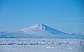
Mount Melbourne seen from the ice-covered Ross Sea
-
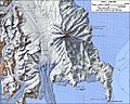
Topographic map of Mount Melbourne (1:250,000 scale) from USGS Mount Melbourne
-
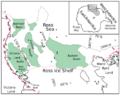
West Antarctic Rift system in the Ross Sea
See also
 In Spanish: Monte Melbourne para niños
