Muncaster Fell facts for kids
Quick facts for kids Muncaster Fell |
|
|---|---|

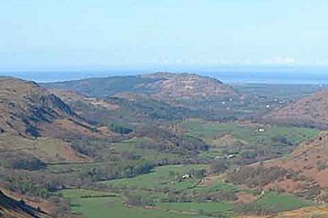
The view west from Hardknott Pass in upper Eskdale, toward Muncaster Fell.
|
|
| Highest point | |
| Elevation | 231 m (758 ft) |
| Prominence | 193 m (633 ft) |
| Parent peak | Illgill Head |
| Listing | Marilyn, Outlying Wainwright, Fellranger |
| Geography | |
| Location | Cumbria, England |
| Parent range | Lake District |
| OS grid | SD115983 |
| Topo map | OS Landranger 89/96, Explorer OL6 |
Muncaster Fell is a beautiful hill, also known as a fell, located on the far western edge of the famous Lake District National Park in Cumbria, England. It's a long, narrow stretch of land, about 1.2 kilometers (0.75 miles) wide and 6 kilometers (3.7 miles) long. This fell sits between two rivers: the River Mite to the north and the River Esk to the south.
Muncaster Fell starts near the coast by Ravenglass village and rises to its highest point, called Hooker Crag, which is 231 meters (758 feet) high. From there, the ridge continues towards the north-east, gently sloping down to another notable spot called Silver Knott (174 meters or 571 feet). Finally, the fell drops quickly to the village of Eskdale Green at its north-eastern end.
Exploring Muncaster Fell's Landscape
Muncaster Fell is a long, low hill with steep sides. It separates the southern parts of the Miterdale and Eskdale valleys. The north-western slopes of the fell have steep cliffs and scree slopes (piles of broken rocks). These slopes drop sharply down to the flat floor of the Mite valley. The narrow-gauge Ravenglass and Eskdale Railway tracks run along the lower parts of this rocky face.
The south-eastern slopes, facing Eskdale, are also quite steep. However, they are gentle enough for several tree plantations to grow there. Near the very southern tip of the fell, you'll find lots of trees. There are natural deciduous woodlands (trees that lose their leaves) and also rhododendron plants, which can spread quickly. At the very south-western end of the fell stands Muncaster Castle. Its gardens are filled with many different types of plants, including a thick patch of bamboo.
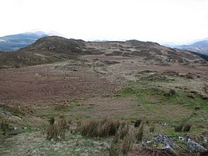
On top of Muncaster Fell, the plants and scenery are typical of the Cumbrian fells. You can find a small tarn (a mountain lake) called Muncaster Tarn (at grid reference SD107978). It sits among trees on the slopes below Hooker Crag. Much of the area between the rocky crags and wet bogs is covered by moss, gorse (a spiky shrub), sedge (grass-like plants), and small groups of bilberry bushes. Recently, a plant called bracken has started to spread across the fell tops, like in many other upland areas of the Lake District. This might be because fewer sheep are grazing there now.
Along the southern part of the fell's ridge, there's a straight path that climbs up past the tarn towards Hooker Crag. This path is actually part of an old Roman road! This road once connected a large Roman fort called Glannoventa near Ravenglass on the coast (about 2 kilometers or 1.2 miles away) to the Roman garrison at Hardknott Roman Fort (known as Mediobogdum to the Romans), which is 14 kilometers (8.7 miles) to the north-east. However, the rest of the Roman route along the ridge top has been lost over time.
You might also spot a small, low stone structure that looks like an ancient dolmen (a stone age tomb). But if you look closely, it has "Ross's Camp 1883" carved on its top surface (at grid reference SD121987). It seems it was built by a group on a shooting trip in that year to be used as a lunch table!
Amazing Views from Muncaster Fell
Muncaster Fell is a special place for walkers. It even has its own chapter in Alfred Wainwright's famous walking guide book, The Outlying Fells of Lakeland. Wainwright suggested walking a loop starting from Muncaster Castle. He recommended following the ridge to Muncaster Head to enjoy the amazing sight of the high fells in the distance. He then suggested returning along the lane south of the fell. Wainwright wrote that "The supreme joy of Muncaster Fell is the delectable traverse of its ridge ... Here is enchantment." This means he found walking along the ridge truly magical!
Muncaster Fell is also listed as a Fellranger. This means it's described in a book series by Richards. It's one of 21 such summits that were not included in Alfred Wainwright's main list of 214 fells.
From the top of Muncaster Fell, you get incredible views because it's quite isolated and close to the coast. You can see the tall mountains of central Cumbria to the north-east. To the north-west and south, you can see the flat coastal plain. On a clear day, you might even spot the Isle of Man across the Irish Sea to the west!
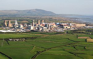
For many years in the late 1900s, the view to the north-west was dominated by the two tall chimneys of the Windscale Piles nuclear reactors. However, these landmarks were taken down in the early 2000s. With other chimneys and cooling towers from the power station also being removed, the Sellafield site now looks much less imposing. But you can still see modern electricity generation! The white turbines of the Walney Wind Farms are clearly visible in the Irish Sea to the south-west.
Understanding Muncaster Fell's Geology
Muncaster Fell is mostly made of granite and microgranite. These rocks are part of the Eskdale Intrusions, which formed in the Late Ordovician period (a very long time ago!). At the south-western end of the fell, between Ravenglass village and Muncaster Castle, there are also some older rocks. These include hornfelsed siltstones and sandstones from the lower Ordovician Skiddaw Group, and andesite rock from the Borrowdale Volcanic Group.
Because Muncaster Fell has quite steep sides, it doesn't have much drift geology (loose material like sand or gravel left by glaciers). The lowest slopes are generally covered in glacial diamicton. This is a mix of rock fragments left behind by glaciers. It comes from the igneous (volcanic) rocks found closer to the center of the Lake District. The steeper cliffs also create local scree deposits (piles of loose rocks). Between the cliffs along the top of the ridge, you'll find small peat bogs. The largest of these is called Hooker Moss (at grid reference SD113984).
 | Misty Copeland |
 | Raven Wilkinson |
 | Debra Austin |
 | Aesha Ash |


