
National Register of Historic Places listings in Dallas County, Arkansas facts for kids

This article is about the special places in Dallas County, Arkansas that are listed on the National Register of Historic Places. This register is like a national list of buildings, sites, and objects that are important to American history, architecture, archaeology, engineering, or culture. When a place is on this list, it means it's recognized as a valuable part of our past and is often protected.
Dallas County has 39 properties and districts on this important list. These places help us understand what life was like long ago in Arkansas. You can even see where many of these places are on a map if their exact location is shared.
Contents
Historic Places in Dallas County
Many different types of places in Dallas County have been added to the National Register. They include old homes, churches, schools, and even train stations. Each one tells a unique story about the area's past.
Homes and Homesteads
Several old houses and homesteads (which are like old family farms) are on the list. These homes show us how people lived, worked, and built their lives in Dallas County many years ago.
- The Amis House in Fordyce was added to the list in 1983. It's an example of the older homes in the area.
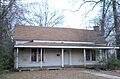
- The Henry Atchley House near Dalark is another historic home.
- The Brazeale Homestead and Butler-Matthews Homestead are examples of old family properties that show the history of farming and settlement.
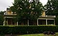
- Other notable homes include the Elliott House, Fielder House, Capt. Goodgame House, Ed Knight House, George W. Mallett House, John Russell House, Jessie B. Smith House, Thomas Homestead, Waters House, and Wynne House. Each of these houses has its own story and unique style from when it was built.
Important Community Buildings
Buildings that served the community, like banks, courthouses, and schools, are also on the list.
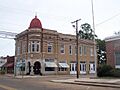
- The Bank of Carthage in Carthage is a historic building that once played a big role in the town's economy.
- The Dallas County Courthouse in Fordyce is a very important building where local government decisions are made. It was listed in 1984.
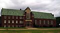
- The Dallas County Training School High School Building in Fordyce is a significant place because it represents the history of education in the county. It was added to the list in 2004.
Churches and Cemeteries
Churches and cemeteries are often very old and hold many memories for a community.
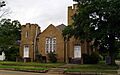
- The First Presbyterian Church and First United Methodist Church, both in Fordyce, are beautiful old churches that have been centers of faith for many years.
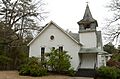
- The Mt. Carmel Methodist Church near Jacinto and the Mt. Zion Methodist Church northeast of Carthage are also on the list.
- The Prosperity Baptist Church near Ramsey and Sardis Methodist Church near Sparkman are other examples of historic churches.
- Old burial grounds like Hampton Springs Cemetery (Black Section), Princeton Cemetery, and Tulip Cemetery are important historical sites. They are places where generations of families are remembered.
Railroad and Commercial History
Trains were once a huge part of how goods and people moved around. Commercial buildings show how towns grew and businesses thrived.
- The Cotton Belt Railroad Depot-Fordyce is a train station built in 1925 with a unique Mediterranean style. It reminds us of the busy days of train travel.
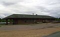
- The Rock Island Railway Depot in Fordyce is another historic train station.
- The Tennessee, Alabama & Georgia Railway Steam Locomotive #101 is a real steam train from 1922! It's a cool piece of history that shows how powerful trains used to be.
- The Fordyce Commercial Historic District includes many old buildings in downtown Fordyce that were part of the town's business center from the late 1800s to the mid-1900s.
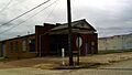
- Other commercial buildings like the Fordyce Home Accident Ins. Co., Marathon Oil Service Station, and Nutt-Trussell Building in Fordyce also tell stories about the town's past businesses.
Old Industries and Other Sites
Some listings show us about old industries and other unique parts of the past.
- The Bird Kiln, Culbertson Kiln, Welch Pottery Works, and Wommack Kiln are examples of old kilns or pottery sites. Kilns are ovens used to bake clay to make pottery or bricks. These sites show us about the early industries in the area.
- The Charlotte Street Historic District in Fordyce is a larger area with many historic buildings that together tell a story about the neighborhood.
- Sadly, some places like Garrison Place near Carthage have been demolished, but they were once important enough to be on the list.
Former Listings
Some places that were once on the National Register of Historic Places in Dallas County have been removed. This can happen if a building is torn down or changed so much that it loses its historical importance.
- The Brewster House in Fordyce was delisted in 2002.
- The Koonce Building and the Old Fordyce Post Office, both in Fordyce, were also removed from the list in 2002.
- The Princeton Methodist Church was delisted in 2002 as well.
These former listings are still part of the county's history, even if they are no longer officially protected by the National Register.
Images for kids
-

The Amis House in Fordyce.
-

The Henry Atchley House.
-

The historic Bank of Carthage.
-

The Brazeale Homestead.
-

The Butler-Matthews Homestead.
-

A building in the Charlotte Street Historic District.
-
The Cotton Belt Railroad Depot in Fordyce.
-
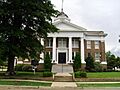
The Dallas County Courthouse.
-

The Dallas County Training School High School Building.
-

The Elliott House in Fordyce.
-
The First Presbyterian Church in Fordyce.
-
The First United Methodist Church in Fordyce.
-
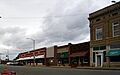
A view of the Fordyce Commercial Historic District.
-
The Fordyce Home Accident Insurance Company building.
-

The Capt. Goodgame House.
-

The Ed Knight House.
-
The Marathon Oil Service Station.
-

Mt. Carmel Methodist Church.
-

Mt. Zion Methodist Church.
-

The Nutt-Trussell Building.
-

The main entrance to Princeton Cemetery.
-

Prosperity Baptist Church.
-
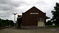
The Rock Island Railway Depot.
-

The John Russell House.
-
Sardis Methodist Church.
-
The Jessie B. Smith House.
-
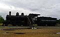
Tennessee, Alabama & Georgia Railway Steam Locomotive #101.
-

The Thomas Homestead.
-

Tulip Cemetery.
-

The Waters House in Fordyce.
-
The Wynne House.


