
National Register of Historic Places listings in Crawford County, Arkansas facts for kids

This article is about the special places in Crawford County, Arkansas that are listed on the National Register of Historic Places. Think of this register as a very important list of buildings, sites, and objects that are worth saving because of their history. These places tell us a lot about the past of Crawford County and the United States.
There are 32 properties and areas in Crawford County that are currently on this special list. Six other places were once listed but have since been removed, usually because they changed too much or were no longer there.
What is the National Register of Historic Places?
The National Register of Historic Places is the official list of the nation's historic places that are considered worthy of preservation. It's like a hall of fame for old buildings, bridges, and important sites. When a place is added to this list, it means it's important for its history, architecture, or what it represents. This helps protect these places for future generations to learn from and enjoy.
Historic Places in Crawford County
Crawford County has many interesting places on the National Register. These include old houses, schools, churches, and even parts of old roads. Each one has a unique story to tell about the people and events that shaped the area.
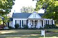
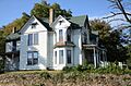
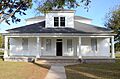
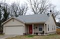
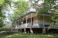
For example, the Dr. Charles Fox Brown House and the Bryan House in Van Buren, Arkansas are beautiful old homes that show how people lived long ago. The Bryant-Lasater House in Mulberry, Arkansas is another example of a historic home.
Some places are important because of famous people. The Bob Burns House in Van Buren belonged to a well-known comedian and musician from the area.
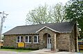
Old schools are also on the list, like the Cedarville School Building and the Mulberry Home Economics Building. These buildings remind us of how education used to be. The No. 12 School near Chester, Arkansas is another example of a historic schoolhouse.
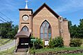
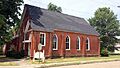
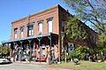
Churches like the Mount Olive United Methodist Church and the Old School Presbyterian Church in Van Buren are also recognized for their historical importance. The Chester Masonic Lodge and Community Building is another community landmark.
Important Transportation Routes
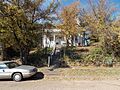
Parts of old roads and bridges are also listed. The Butterfield Overland Mail Route was a very important mail and passenger service in the 1850s. Segments of this old route, like the Lee Creek Road Segment and the Lucian Wood Road Segment near Cedarville, Arkansas, are on the register. These segments show where people traveled and delivered mail over 150 years ago.
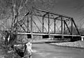
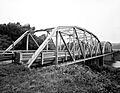
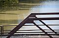
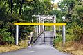
Several bridges are also listed, such as the Frog Bayou Bridge near Mountainburg, Arkansas and the Lee Creek Bridge near Natural Dam, Arkansas. These bridges are important examples of engineering from the past. The Mulberry River Bridge also connects Crawford County to Franklin County, Arkansas. Even a part of Old U.S. 64 in Van Buren is recognized as a historic road segment.
Other Notable Sites
The Drennen-Scott House in Van Buren is a very special place. It is recognized as a Trail of Tears site. The Trail of Tears was a sad and difficult journey when many Native American people were forced to move from their homes. This house helps us remember that important part of history.
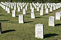
Cemeteries like Fairview Cemetery and its Confederate Section in Van Buren are also listed. These places are important for understanding the history of the community and the people who lived there.
The Van Buren Historic District is a large area in Van Buren that includes many historic buildings, especially along Main Street. This district gives us a great look at what a town looked like long ago. The Van Buren Confederate Monument is also located within this historic district.
The Van Buren Post Office is another historic building that served the community for many years. The Wilhauf House and the Col. Jacob Yoes Building in Chester are also important historic structures.
Places That Were Once Listed
Sometimes, a place is removed from the National Register. This can happen if the building is changed too much, or if it is no longer standing. In Crawford County, six places were once listed but are no longer on the register. These include a few bridges like the Cedar Creek Bridge and the Crawford County Road 32D Bridge, and the Mountainburg High School. Even though they are no longer listed, they were once considered important parts of history.
Images for kids
-
The Dr. Charles Fox Brown House
-
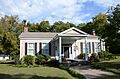
The Bryan House
-
The Bryant-Lasater House
-
The Bob Burns House
-
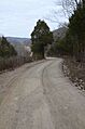
A segment of the Butterfield Overland Mail Route
-
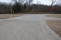
Another segment of the Butterfield Overland Mail Route
-
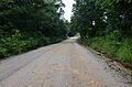
A segment of the Butterfield Overland Mail route
-
The Cedarville School Building
-
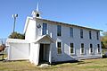
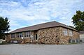
The Chester Masonic Lodge and Community Building
-
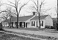
The Clarke-Harrell-Burson House
-
The Drennen-Scott House
-
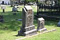
A monument in Fairview Cemetery
-
The Confederate Section of Fairview Cemetery
-
The Frog Bayou Bridge
-
The Lee Creek Bridge near Natural Dam
-
The Lee Creek Bridge in Van Buren
-
The Henry Clay Mills House
-
The Mount Olive United Methodist Church
-
The Mulberry Home Economics Building
-
The Mulberry River Bridge
-
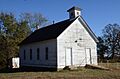
The No. 12 School
-
The Old School Presbyterian Church
-

A segment of Old U.S. 64
-
The Slack-Comstock-Marshall Farm House
-
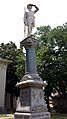
The Van Buren Confederate Monument
-
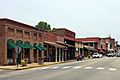
Main Street in the Van Buren Historic District
-
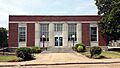
The Van Buren Post Office
-
The Wilhauf House
-
The Col. Jacob Yoes Building


