
National Register of Historic Places listings in Little River County, Arkansas facts for kids

Welcome to Little River County, Arkansas! This page is all about the special places in the county that are listed on the National Register of Historic Places. Think of this Register as a very important list of buildings, areas, and sites across the United States that have a lot of history. When a place is added to this list, it means it's recognized as important for its history, architecture, or what happened there. This helps protect these places so future generations can learn from them.
Little River County has 16 amazing places on this list, plus one that used to be listed. Let's explore some of these cool historic spots!
Contents
Historic Places in Little River County
Little River County is home to many interesting historic sites. These places tell stories about how people lived, worked, and traveled long ago.
Homes with History
Many of the buildings on the National Register are old homes that show how people lived in the past.
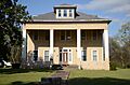
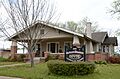
Judge Jefferson Thomas Cowling House
The Judge Jefferson Thomas Cowling House is in Ashdown. It's a beautiful old house that was built a long time ago. Judge Cowling was an important person in the community, and his home is a great example of the architecture from that time. It was added to the list in 1988.
Hawkins House
Also in Foreman, the Hawkins House is another historic home. It's located at the corner of 3rd Avenue and 3rd Street. This house was recognized in 1996 for its historical value.
Hunter-Coulter House
The Hunter-Coulter House is found in Ashdown. It sits at the corner of 2nd and Commerce Streets. This house was listed in 1996, showing its importance to the local history and architecture of Ashdown.
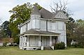
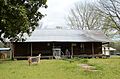
Will Reed Farm House
The Will Reed Farm House is located on Main Street in Alleene. This farm house gives us a peek into what rural life was like in Little River County many years ago. It was added to the National Register in 1978.
Important Buildings and Districts
Beyond homes, other buildings and even whole areas are recognized for their historical significance.
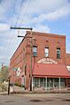
Anderson-Hobson Mercantile Store
In Foreman, you can find the Anderson-Hobson Mercantile Store. This old store, listed in 1996, was once a busy place where people bought goods and supplies. It shows us what shopping was like before big supermarkets.
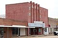
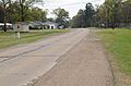
Ashdown Commercial Historic District
The Ashdown Commercial Historic District is a special area in Ashdown. It includes many historic buildings that were once part of the town's main business area. This district was added to the list in 2008 because it helps us understand the town's growth and economy.
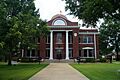
Little River County Courthouse
The Little River County Courthouse in Ashdown is a very important building. It's where many official county decisions have been made for over a century. Built in 1907, it's a great example of neoclassical style architecture and was listed in 1976.
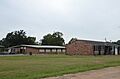
Little River County Training School Historic District
The Little River County Training School Historic District in Ashdown tells an important story about education. This district, listed in 2016, represents a time when schools were built to provide training and education for specific communities.
New Rocky Comfort Jail
The New Rocky Comfort Jail in Foreman is a unique historic building. This old jail, listed in 1994, gives us a glimpse into the justice system of the past.
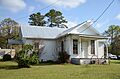
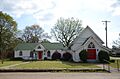
St. Barnabas Episcopal Church
The St. Barnabas Episcopal Church in Foreman is a beautiful historic church. Located at the junction of Tracy Lawrence Avenue and Bell Street, it was added to the National Register in 1998. Churches often play a central role in a community's history.
Transportation and Travel History
Some listings highlight how people and goods moved around the county.
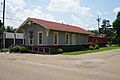
Memphis, Paris and Gulf Railroad Depot
The Memphis, Paris and Gulf Railroad Depot in Ashdown was once a busy train station. Listed in 1994, it reminds us of the days when trains were a main way to travel and transport goods across the country.
Texarkana and Fort Smith Railway Depot
Another important railway building is the Texarkana and Fort Smith Railway Depot in Wilton. This depot, listed in 2008, also played a key role in connecting communities and moving goods by train.
Old US 71 Segments
Several parts of the Old US 71 highway are listed as historic. These segments, including the Ashdown Segment, Ogden Segment, and Wilton Segment, show us how roads were built and used in earlier times. They were important routes for cars and trucks before modern highways were constructed. These segments were listed in 2013 and 2004.
Other Historic Sites
Not all historic places are buildings. Some are sites like cemeteries.
Mills Cemetery
The Mills Cemetery near Wilton is a historic burial ground. Cemeteries can tell us a lot about the people who lived in an area, their families, and how long ago they lived. This cemetery was listed in 2007.
Former Listing
Sometimes, a historic place might be removed from the National Register. This usually happens if the building is changed too much or is no longer standing.
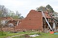
S.S.P. Mills and Son Building
The S.S.P. Mills and Son Building in Wilton was once on the National Register. It was listed in 1996 but was later removed in 2014. This building was an important part of Wilton's history, but it was taken off the list after it was demolished.
Images for kids
-
The Anderson-Hobson Mercantile Store in Foreman.
-
A view of the Ashdown Commercial Historic District.
-
The historic Judge Jefferson Thomas Cowling House.
-
The Hawkins House in Foreman.
-
The Hunter-Coulter House in Ashdown.
-
The Little River County Courthouse.
-
The Little River County Training School Historic District.
-
The Memphis, Paris and Gulf Railroad Depot.
-
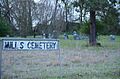
Mills Cemetery near Wilton.
-
The New Rocky Comfort Jail in Foreman.
-
A segment of Old US 71 near Ashdown.
-
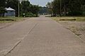
A segment of Old US 71 near Ogden.
-

A segment of Old US 71 near Wilton.
-
The Will Reed Farm House in Alleene.
-
St. Barnabas Episcopal Church in Foreman.
-

The Texarkana and Fort Smith Railway Depot in Wilton.
-
The S.S.P. Mills and Son Building during demolition.


.jpg)

.jpg)


