
National Register of Historic Places listings in Desha County, Arkansas facts for kids

This article is about the cool and important places in Desha County, Arkansas that are listed on the National Register of Historic Places. Think of the National Register as a special list of buildings, sites, and objects that are important to American history, architecture, archaeology, engineering, or culture. When a place is on this list, it means it's recognized for its special value and efforts are made to protect it.
Desha County, in Arkansas, has 26 places on this special list! One of them is even a National Historic Landmark, which is an even higher level of importance. You can see where these places are on a map if you look up their coordinates.
Contents
What is the National Register of Historic Places?
The National Register of Historic Places is like a hall of fame for historic sites across the United States. It's managed by the National Park Service. When a place is added to the Register, it means it's considered important enough to be saved and celebrated for future generations. This can include anything from old houses and schools to entire neighborhoods or even archaeological sites.
Historic Places in Desha County
Desha County is full of interesting history, and many of its important buildings and areas are recognized on the National Register. Let's explore some of them!
Arkansas City's Historic Gems
Arkansas City was once a very busy river port. Many of its old buildings and areas tell stories of its past.
- Arkansas City Commercial District: This area includes several old buildings along Desoto Avenue and Sprague Street. It shows what the town's main business area looked like a long time ago.
- Arkansas City High School: Located on Robert S. Moore and President Streets, this old school building is a reminder of how education has changed over the years.
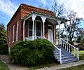
- Desha County Courthouse: This important building on Robert S. Moore Avenue is where many official county decisions have been made for decades.
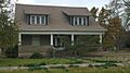
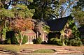
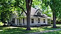
- Dickinson-Moore House: Found at 707 Robert S. Moore Avenue, this house gives us a peek into how people lived in the past.
- Hubert & Ionia Furr House: At 702 Desoto Avenue, this house is another example of the historic homes in Arkansas City.
- Xenophon Overton Pindall Law Office: This small office at the junction of Capitol and Kate Adams Streets belonged to a famous lawyer and politician from Arkansas.
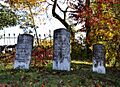
- Mound Cemetery: About half a mile north of Arkansas City, this old cemetery is a quiet place that holds the history of many early residents.
- Thane House: Located at Levy and 1st Streets, this house is another historic home in the city.
McGehee's Important Sites
McGehee is another city in Desha County with many historic places, especially those related to its railroad history.
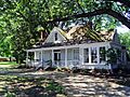
- Jay Lewis House: This house at 12 Fairview Drive is a historic home in McGehee.
- McGehee City Jail: The old jail, found at the southwest corner of S. First Street and Pine Street, tells a story about law and order in the past.
- McGehee National Guard Armory: This building at 1610 S. 1st Street was used by the National Guard, a part of the military that helps in emergencies.
- McGehee Post Office: Located at 201 N. Second Street, this post office has served the community for many years.
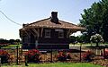
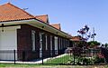
- Missouri Pacific Railroad Depot-McGehee and Van Noy Eating House: These two buildings, near the intersection of Seamans Drive and Railroad Street, were very important for train travel. The depot was where people boarded trains, and the eating house was where they could get a meal during their journey.
- Parnell-Sharpe House: This historic home is located at 302 N. 2nd Street.
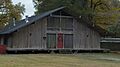
- Temple Meir Chayim: At the junction of 4th and Holly Streets, this temple is a significant religious building in McGehee.
- Trippe Holly Grove Cemetery: About 2 miles south of McGehee, this cemetery is another historic burial ground in the county.
Dumas's Historic Buildings
Dumas also has its share of historic places, especially in its downtown area.
- Dumas Commercial Historic District: This district along S. Main Street between Choctaw and Waterman Streets shows what the main shopping and business area of Dumas looked like in earlier times.
- McKennon-Shea House: This house at 206 Waterman Street is a historic residence in Dumas.
- Merchants & Farmers Bank: Located at Waterman and Main Streets, this old bank building was once a key part of the town's economy.
- Dr. J.D. Watts House: Found at 205 W. Choctaw, this house belonged to a doctor and is another historic home in Dumas.
The Rohwer War Relocation Center
The Rohwer War Relocation Center is a very important site in Desha County, so important that it's a National Historic Landmark. During World War II, many Japanese Americans were forced to leave their homes and live in special camps, even though they had done nothing wrong. The Rohwer Center was one of these camps.
Today, the site, located on Arkansas Highway 1, includes a memorial cemetery. It serves as a powerful reminder of a difficult time in American history and helps us learn about fairness and civil rights.
Images for kids
-
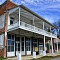
The Arkansas City Commercial District
-
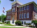
Arkansas City High School
-
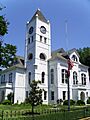
Desha County Courthouse
-
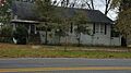
The Dickinson-Moore House
-

Downtown Dumas
-
The Hubert & Ionia Furr House
-
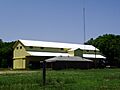
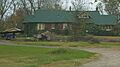
The Kemp Cotton Gin
-
The Jay Lewis House
-
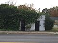
The McGehee City Jail
-

The McGehee National Guard Armory
-
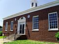
The McGehee Post Office
-
The McKennon-Shea House
-
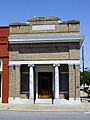
The Merchants & Farmers Bank
-
The Missouri Pacific Railroad Depot in McGehee
-
The Missouri Pacific Railway Van Noy Eating House
-
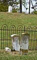
Mound Cemetery
-
The Parnell-Sharpe House
-
The Xenophon Overton Pindall Law Office
-

The Rohwer Relocation Center Memorial Cemetery
-

Volunteers at the Rohwer Relocation Center
-
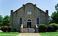
Temple Meir Chayim
-
The Thane House
-
Trippe Holly Grove Cemetery
-
The Dr. J.D. Watts House


