
National Register of Historic Places listings in Marion County, Arkansas facts for kids

Have you ever wondered about the old buildings, bridges, or special places in your town? Some of these places are so important that they are added to a special list called the National Register of Historic Places. This list helps protect and celebrate places that have a unique history in the United States.
In Marion County, Arkansas, there are many such places! This article will tell you about some of the cool historic spots in Marion County that are on this important list. There are currently 22 places listed, and one that used to be on the list.
What is the National Register of Historic Places?
The National Register of Historic Places is like a special hall of fame for buildings, sites, structures, objects, and districts that are important in American history, architecture, archaeology, engineering, or culture. When a place is added to this list, it means it's recognized as a valuable part of our past. This helps people understand and appreciate history, and it can also help protect these places for future generations.
Historic Schools in Marion County
Many old school buildings in Marion County are on the National Register. These schools tell us a lot about what education was like a long time ago.
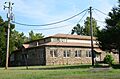
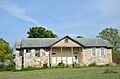
Aggie Hall and Aggie Workshop
In Bruno, Arkansas, you can find two buildings called Aggie Hall and Aggie Workshop. They were listed on the National Register in 1992. These buildings were likely part of a school or agricultural program, helping students learn important skills for farming and life in the community.
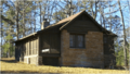
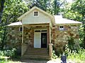
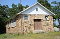
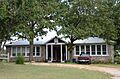
Cold Springs School
The Cold Springs School is another historic school building, located near Big Flat, Arkansas. It was added to the list in 1992. Imagine what it was like to go to school here many years ago!
Eros School Building
The Eros School Building in Eros, Arkansas, also joined the National Register in 1992. These old schoolhouses often served as important centers for their communities, not just for learning but also for social gatherings.
Fairview School Building
In Fairview, Marion County, Arkansas, the Fairview School Building was recognized in 1992. It's a reminder of how education has changed over time.
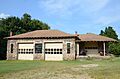
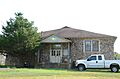
Pea Ridge School Building
The Pea Ridge School Building, located south of Bruno, Arkansas, was listed in 1993. It shows how schools were often built in rural areas to serve local families.
Pyatt School Building
Near Pyatt, Arkansas, the Pyatt School Building was added to the list in 1992. These old school buildings are like time capsules, showing us how communities grew and educated their children.
Important Buildings and Stores
Marion County also has several historic buildings that were important for daily life and business.
J.C. Berry's Dry Goods Store
In Yellville, Arkansas, the J.C. Berry's Dry Goods Store was listed in 2003. Dry goods stores were like general stores where people could buy all sorts of things, from clothes to tools. This building gives us a peek into how people shopped in the past.
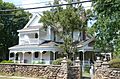
Carter-Jones House
The Carter-Jones House, also in Yellville, Arkansas, became a historic listing in 1987. Old homes like this often show us the architectural styles and living conditions of earlier times.
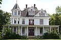
Cowdrey House
Another historic home in Yellville, Arkansas is the Cowdrey House, listed in 1978. These houses help us understand the history of families and communities.
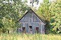
Hirst-Mathew Hall
Back in Bruno, Arkansas, the Hirst-Mathew Hall was listed in 1992. Like Aggie Hall, this building likely played a role in the community's social or educational life.
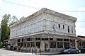
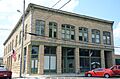
Layton Building
The Layton Building in Yellville, Arkansas, listed in 1978, was an important commercial building. It reminds us of the businesses that helped towns grow.
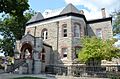
Marion County Courthouse
The Marion County Courthouse in Yellville, Arkansas, listed in 1994, is a very important building. Courthouses are where local government takes place, and they are often central to a town's history and identity.
Estes-Williams American Legion Hut #61
Also in Yellville, Arkansas, the Estes-Williams American Legion Hut #61 was listed in 2001. American Legion huts are often places where veterans gather and where community events are held.
Bridges and Tunnels
Infrastructure like bridges and tunnels can also be historic! They show us how people traveled and transported goods long ago.
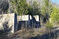
Cotter Tunnel
The Cotter Tunnel near Cotter, Arkansas, was listed in 2007. Tunnels are amazing feats of engineering, allowing roads or railways to pass through mountains or under other obstacles.
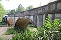
Crooked Creek Bridge
The Crooked Creek Bridge in Pyatt, Arkansas, listed in 2010, is an example of an important historic bridge. Bridges connect communities and are vital for transportation.
Pyatt Tunnel
Another tunnel, the Pyatt Tunnel near Pyatt, Arkansas, was listed in 2007. These structures are often built to help trains or cars pass through difficult terrain.
US 62 Bridge over Crooked Creek
A second bridge over Crooked Creek, the US 62 Bridge over Crooked Creek, also in Pyatt, Arkansas, was listed in 2000. This shows how important this creek crossing has been for travel.
Natural and Historic Districts
Some places are listed because they are natural areas or groups of buildings that together tell a story.
Buffalo River State Park
Part of the famous Buffalo National River near Yellville, Arkansas, the Buffalo River State Park was listed in 1988. This park is known for its beautiful natural scenery and outdoor activities.
Rush Historic District
The Rush Historic District near Yellville, Arkansas, listed in 1987, is a special area. Historic districts are groups of buildings or sites that are important together, often because they show how a town or industry developed. Rush was once a mining town, and this district preserves its history.
Sunburst Shelter
The Sunburst Shelter near Summit, Arkansas, listed in 1982, is a unique type of historic place. Shelters like this can be important archaeological sites, showing evidence of early human life. Its exact location is kept secret to protect it.
Former Listing
Sometimes, a place that was once on the National Register of Historic Places is removed from the list. This can happen if the building is destroyed or changed so much that it no longer has its historic importance.
Bruno School Building
The Bruno School Building in Bruno, Arkansas, was listed in 1992 but was removed from the list in 2017. This means it no longer meets the requirements to be considered a historic place on the National Register.
Images for kids
-
Aggie Hall
-
Aggie Workshop
-
J.C. Berry's Dry Goods Store
-
Buffalo River State Park
-
Carter-Jones House
-
Cold Springs School
-
Cowdrey House
-
Crooked Creek Bridge
-
Eros School Building
-
Fairview School Building
-
Hirst-Mathew Hall
-
Layton Building
-
Marion County Courthouse
-
Pea Ridge School Building
-
Pyatt School Building
-
Rush Historic District


