
National Register of Historic Places listings in Lawrence County, Arkansas facts for kids

Have you ever wondered about old buildings or special places in your town? Some places are so important that they get listed on something called the National Register of Historic Places. This is a special list in the United States that helps protect and celebrate historic sites. It's like a hall of fame for buildings, bridges, and other spots that tell a story about the past.
This article is all about the amazing historic places found in Lawrence County, Arkansas. There are 27 different places and areas in Lawrence County that are on this list! These places help us learn about how people lived, worked, and built things a long time ago.
Contents
What is the National Register of Historic Places?
The National Register of Historic Places is the official list of the nation's historic places worth saving. It's managed by the National Park Service. When a place is listed, it means it's important for its history, architecture, or what it represents. Listing helps protect these places and can even help owners get grants for repairs.
Historic Places in Lawrence County
Lawrence County has many interesting places on the National Register. These sites show different parts of the county's history. From old schools to courthouses and even bridges, each one has a unique story.
Buildings with History
Many of the listed places are buildings. These include homes, schools, and government buildings.
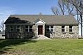
- Dr. F.W. Buercklin House: This house in Portia was built a long time ago. It tells us about how people lived in the late 1800s.
- Clover Bend High School: Located in Clover Bend, this old school building reminds us of how education used to be. It's a key part of the community's past.
- Commandant's House: In Walnut Ridge, this house was once home to an important military leader. It's a piece of history from the World War II era.
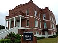
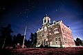
- Lawrence County Courthouse: This important building in Walnut Ridge is where many county decisions have been made. It shows the history of local government.
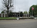
- Old Walnut Ridge Post Office: This building in Walnut Ridge once handled all the mail for the area. It's a reminder of how communication worked before the internet.
- Powhatan Courthouse: In Powhatan, this very old courthouse was built in 1888. It's a central part of the Powhatan Historic State Park.
- Powhatan Jail: Right next to the courthouse in Powhatan is the old jail. It shows us what law enforcement was like in the past.
- Powhatan Methodist Church: This church in Powhatan is a beautiful example of old church architecture. It has been a place of worship for many years.
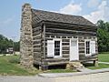
- Powhatan Schoolhouse: Also in Powhatan, this schoolhouse teaches us about early education in the county.
Important Districts and Areas
Sometimes, a whole area or group of buildings is listed together. This is called a historic district.
- Clover Bend Historic District: This area in Clover Bend includes several important buildings. They show what a small farming community looked like in the past.
- Walnut Ridge Commercial Historic District: This district in Walnut Ridge includes many old shops and businesses. It shows how the town's main street grew over time.
Bridges and Roads
Even bridges and roads can be historic! They show how people traveled and transported goods.
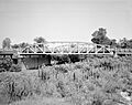
- Cache River Bridge: This bridge carries Arkansas Highway 25 over the Cache River near Walnut Ridge. It's an example of early bridge building.
- Old US 67, Alicia to Hoxie: A section of the old U.S. Route 67 is listed. This road was a major route for travelers and goods.
- St. Louis-San Francisco Overpass: This overpass in Imboden goes over the Spring River. It's a historic railway structure.
- Walnut Ridge Army Airfield Access Road: This road led to a former military airfield. It played a role in World War II.
Former Listings
Sometimes, a place might be removed from the National Register. This can happen if it is changed too much or if it is destroyed. In Lawrence County, two places were once listed but are no longer on the Register:
- Alice French House: This house in Clover Bend was listed in 1976 but was removed in 2002.
- US 63 Black River Bridge: This bridge near Black Rock was listed in 2000 but was removed in 2017.
Images for kids
-

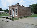
Building Number 29 in Walnut Ridge
-
The historic Cache River Bridge
-
The Commandant's House in Walnut Ridge
-
The Ficklin-Imboden House in Powhatan
-

Dr. John Octavius Hatcher House in Imboden
-
Imboden Methodist Episcopal Church, South
-
The Lawrence County Courthouse in Walnut Ridge
-
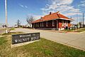
The Missouri Pacific Depot in Walnut Ridge
-

The Old Walnut Ridge Post Office
-
The Portia School
-
The Powhatan Courthouse
-
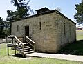
The Powhatan Jail
-
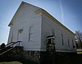
The Powhatan Methodist Church
-
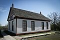
The Powhatan Schoolhouse
-

The St. Louis-San Francisco Overpass
-
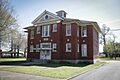
The Telephone Exchange Building in Powhatan
-

The Walnut Ridge Army Airfield Access Road
-
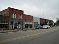
A view of the Walnut Ridge Commercial Historic District


.jpg)


