Newport County, Rhode Island facts for kids
Quick facts for kids
Newport County
|
|
|---|---|

|
|
| Country | |
| State | |
| Region | New England |
| Metro area | Providence |
| Formed | June 22, 1703 |
| Named for | Newport, Essex |
| County town | Newport |
| Largest city | Newport |
| Incorporated municipalities |
6 (total)
1 city, 5 towns
|
| Area | |
| • Total | 314 sq mi (810 km2) |
| • Land | 102 sq mi (260 km2) |
| • Water | 211 sq mi (550 km2) 67%% |
| Highest elevation | 326 ft (99 m) |
| Lowest elevation | 0 ft (0 m) |
| Population | |
| • Total | 85,643 |
| • Density | 270/sq mi (100/km2) |
| GDP | |
| • Total | $7.843 billion (2022) |
| Time zone | UTC−5 (EST) |
| • Summer (DST) | UTC−4 (EDT) |
| ZIP Code format |
028xx
|
| Area code | 401 |
| FIPS code | 44-005 |
| GNIS feature ID | 1219779 |
| Congressional district | 1st |
Newport County is one of five counties in Rhode Island. In 2020, about 85,643 people lived here. It's also one of Rhode Island's seven regions. The county was created in 1703.
Unlike counties in many other states, Newport County doesn't have its own government. The state government and local cities and towns handle most services. Counties in Rhode Island mainly help with court and sheriff duties. Newport County is part of the larger Providence Metropolitan Area.
Contents
A Look Back in Time: History of Newport County
Newport County was formed on June 22, 1703. It was one of the first two counties in the Colony of Rhode Island. When it first started, it included four towns: Portsmouth, Newport, Jamestown, and New Shoreham.
Later, in 1746–47, two more towns, Little Compton and Tiverton, joined from Massachusetts. In 1856, the town of Fall River was created from Tiverton. However, it was given back to Massachusetts in 1862. This happened to settle a border disagreement between Rhode Island and Massachusetts.
In 1963, the town of New Shoreham moved to Washington County. Rhode Island stopped having county governments in 1842. Today, counties like Newport County are mostly used for organizing courts.
Where is Newport County? Geography
Newport County covers about 314 square miles. About 102 square miles of this is land. The other 211 square miles, which is 67%, is water.
The county includes several islands. These are Aquidneck Island, Conanicut Island, and Prudence Island. It also has a part of the mainland on the eastern side of the state.
The highest point in the county is Pocasset Hill. It is about 320 feet (98 meters) above sea level. You can find it in Tiverton. The lowest point is at sea level.
Neighboring Counties
- Bristol County - to the north
- Bristol County, Massachusetts - to the east
- Kent County - to the northwest
- Washington County - to the west
Special Protected Areas
These are places protected for nature or history:
Main Roads and Highways
Here are some of the major roads in Newport County:
 Route 24
 Route 77
 Route 81
 Route 114
 Route 138
 Route 138A
 Route 179
 Route 214
 Route 238
People of Newport County: Demographics
| Historical population | |||
|---|---|---|---|
| Census | Pop. | %± | |
| 1790 | 14,351 | — | |
| 1800 | 14,845 | 3.4% | |
| 1810 | 16,294 | 9.8% | |
| 1820 | 15,771 | −3.2% | |
| 1830 | 16,535 | 4.8% | |
| 1840 | 16,874 | 2.1% | |
| 1850 | 20,007 | 18.6% | |
| 1860 | 21,896 | 9.4% | |
| 1870 | 20,050 | −8.4% | |
| 1880 | 24,180 | 20.6% | |
| 1890 | 28,552 | 18.1% | |
| 1900 | 32,599 | 14.2% | |
| 1910 | 39,335 | 20.7% | |
| 1920 | 42,893 | 9.0% | |
| 1930 | 41,668 | −2.9% | |
| 1940 | 46,696 | 12.1% | |
| 1950 | 61,539 | 31.8% | |
| 1960 | 81,891 | 33.1% | |
| 1970 | 94,559 | 15.5% | |
| 1980 | 81,383 | −13.9% | |
| 1990 | 87,194 | 7.1% | |
| 2000 | 85,433 | −2.0% | |
| 2010 | 82,888 | −3.0% | |
| 2020 | 85,643 | 3.3% | |
| U.S. Decennial Census 1790-1960 1900-1990 1990-2000 2010-2019 |
|||
Population in 2010
In 2010, there were 82,888 people living in Newport County. These people lived in 34,911 households. About 21,076 of these households were families. The county had about 810 people per square mile of land.
Most people in the county (90.2%) were white. Other groups included Black or African American (3.5%), Asian (1.6%), and American Indian (0.4%). About 4.2% of the population was of Hispanic or Latino background.
Many people in Newport County have Irish roots (25.5%). Other common backgrounds include English (17.4%), Portuguese (16.5%), Italian (10.9%), and German (10.5%).
About 26.2% of households had children under 18 living with them. The average age of people in the county was 43.2 years.
The middle income for a household was about $67,239. For families, the middle income was about $82,477. About 7.3% of all people in the county lived below the poverty line. This included 10.4% of those under 18.
Cities, Towns, and Villages
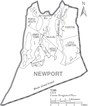
Newport County has one city and five towns.
City
Towns
Census-Designated Places (CDPs)
CDPs are areas that are like towns but are not officially incorporated.
Villages
Villages in Rhode Island are parts of towns and don't have their own separate governments.
- Adamsville
- Bridgeport
- Briggs Point
- Bristol Ferry
- Castle Hill
- Cedar Island
- Cedar Point
- Coasters Harbor
- Coddington Point
- Common Fence Point
- Corey Lane
- Despair Island
- Dutch Island
- Dyer Island
- Eagleville
- Easton Point
- Fogland Point
- Fort Adams
- Forty Steps
- Freebody Hill
- Goat Island
- Gould Island
- Grayville
- Green's End
- Hog Island
- Homestead
- Hope Island
- Hummocks
- Island Park
- Nannaquaket
- North Tiverton
- Ochre Point
- Patience Island
- Prudence Island
- Quaker Hill
- Rose Island
- Sachuest
- Sakonnet
- Tiverton Four Corners
- Tonomy Hill
- Tunipus
Learning in Newport County: Education
Here are the school districts in Newport County:
Schools for All Grades (K-12)
- Middletown Public Schools
- Newport Public Schools
- Portsmouth School District
- Tiverton School District
Elementary Schools Only
- Jamestown School District
- Little Compton School District
See also
 In Spanish: Condado de Newport para niños


