Nile Delta facts for kids
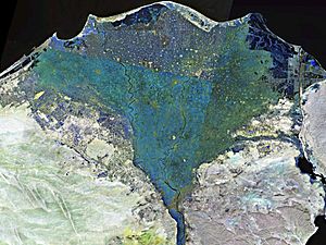
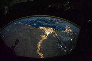
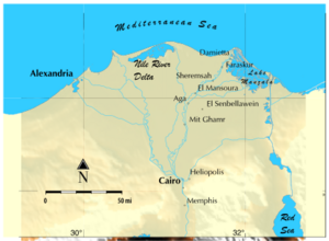
The Nile Delta is a special land shape in Lower Egypt. It's where the mighty Nile River spreads out into many smaller streams. These streams then flow into the Mediterranean Sea. Imagine a giant fan or a triangle; that's what the delta looks like from above!
It's one of the biggest river deltas in the world. It stretches about 240 kilometers (150 miles) along the Mediterranean coast. This area is super important for agriculture because its soil is very rich. The delta starts just a bit north of Cairo. From north to south, it's about 160 kilometers (100 miles) long.
Contents
Geography of the Nile Delta
The Nile Delta is shaped like an arc or a triangle. It stretches about 160 kilometers (100 miles) from north to south. From west to east, it covers about 240 kilometers (150 miles) of coastline.
The Nile River splits into two main branches here. These are called the Damietta and the Rosetta branches. They flow into the Mediterranean Sea at cities with the same names. Long ago, the delta had more branches. But over time, some of these dried up because of floods and changes in the land.
The Suez Canal is to the east of the delta. It connects to Lake Manzala in the northeast. To the northwest, there are three other large coastal lakes. These are Lake Burullus, Lake Idku, and Lake Mariout.
Today, the edges of the delta are slowly wearing away. Some coastal lakes are also becoming saltier. This is because they are more connected to the Mediterranean Sea. The delta used to get fresh soil and nutrients from the Nile's yearly floods. But the Aswan Dam stopped these floods. Now, farmers need to use a lot of fertilizers. The rich topsoil in the delta can be as deep as 21 meters (70 feet)!
History of the Nile Delta
People have lived in the Nile Delta for thousands of years. They have farmed this land for at least 5,000 years. The delta was a very important part of ancient Lower Egypt. Many old cities and historical sites are found here.
One famous discovery in the delta was the Rosetta Stone. It was found in 1799 in the city of Rosetta. This stone helped us understand ancient Egyptian hieroglyphs!
In 2019, amazing discoveries were made in the sunken city of Heracleion. This city is sometimes called Egypt's Atlantis. Divers found a small Greek temple, old granite columns, and ships filled with treasure. They also found bronze coins from the time of Ptolemy II, who lived over 2,000 years ago.
Also in 2019, archaeologists found ancient tombs in the Kom Al-Khelgan area. These tombs were from different periods of Egyptian history. They contained animal remains, amulets, and scarabs. They also found pots, flint knives, and broken pottery.
Ancient Nile Branches
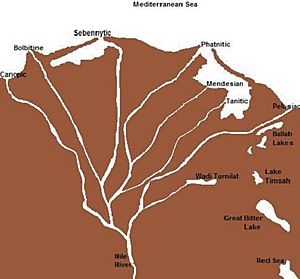
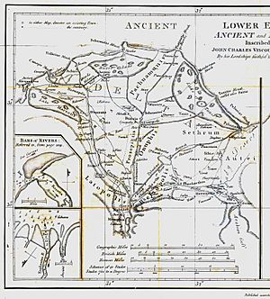
Ancient records, like those from Ptolemy, say the Nile Delta once had seven main branches. These branches flowed from east to west:
- The Pelusiac
- The Tanitic
- The Mendesian
- The Phatnitic (later called the Damietta)
- The Sebennytic
- The Bolbitine (later called the Rosetta)
- The Canopic
Today, only the Damietta and Rosetta branches still exist. The other five have dried up over many centuries. This happened because of flood control and the buildup of silt. The delta used to flood every year, which brought new soil. But this stopped when the Aswan Dam was built.
People of the Nile Delta
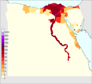
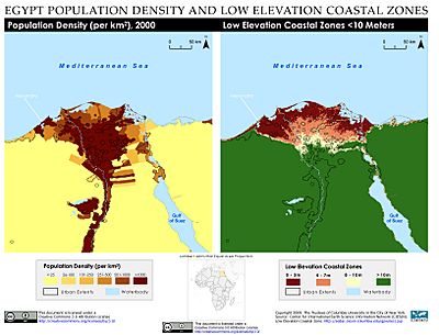
About 39 million people live in the Nile Delta region. In many areas outside the big cities, there are more than 1,000 people living in every square kilometer.
Alexandria is the largest city in the delta. It has over 4.5 million people. Other big cities include Shubra El Kheima, Port Said, El Mahalla El Kubra, Mansura, Tanta, and Zagazig.
Wildlife of the Nile Delta
The Nile Delta is home to many interesting plants and animals. In autumn, parts of the Nile River are covered with beautiful lotus flowers. The northern part of the Nile has many plants, including the Egyptian lotus. The Papyrus Sedge (Cyperus papyrus) also grows here. However, it is much rarer now than it used to be.
Hundreds of thousands of water birds spend the winter in the delta. This includes huge numbers of little gulls and whiskered terns. Other birds you might see are grey herons, Kentish plovers, shovelers, cormorants, egrets, and ibises.
Other animals living in the delta include frogs, turtles, tortoises, and mongooses. You might also spot the Nile monitor, a type of lizard. Long ago, Nile crocodiles and hippopotamus lived here, but they are no longer found in the delta. Some fish, like the flathead grey mullet and soles, live in the delta's waters.
Climate of the Nile Delta
The Nile Delta has a hot desert climate, like most of Egypt. However, the northern part of the delta, near the coast, has milder temperatures. In summer, the highest temperatures usually don't go above 31°C (88°F).
The delta gets only about 100 to 200 millimeters (4 to 8 inches) of rain each year. Most of this rain falls during the winter months. The hottest months are July and August, with average high temperatures around 34°C (93°F). In winter, temperatures usually range from 9°C (48°F) at night to 19°C (66°F) during the day. The delta can feel quite humid in winter because of the cooler temperatures and some rain.
Sea Level Rise and the Delta
Egypt's Mediterranean coastline is losing land to the sea. In some places, the sea takes away as much as 91 meters (100 yards) of land each year. The low-lying Nile Delta is especially at risk from sea level rise. This problem is made worse because the Aswan Dam stops new sediments from reaching the delta.
If the polar ice caps melt, a large part of the northern delta could disappear under the Mediterranean Sea. This includes the ancient city of Alexandria. Even a small rise of 30 centimeters (1 foot) in sea level could affect about 6.6% of the delta's land.
If the sea level rises by 1 meter (3.3 feet), nearly 900,000 people could be at risk of flooding. A lot of land could be destroyed, including:
- About 100 square kilometers (39 square miles) of plants
- 16 square kilometers (6 square miles) of wetlands
- 402 square kilometers (155 square miles) of farmland
- 47 square kilometers (18 square miles) of city areas
About 450 square kilometers (174 square miles) of land could be flooded. Some farmland in the delta has already become salty because of the rising sea. This means farming has stopped in some places.
Rising sea levels could also harm the delta's ecosystems and its tourism industry. Food shortages from climate change could even create millions of "climate refugees" in the future.
The delta's coastline has also changed a lot. People have turned coastal dunes and lagoons into new farmland and fish farms. Cities along the coast have also grown bigger.
Governorates and Large Cities
The Nile Delta is part of these 10 governorates (like states or provinces):
Here are some large cities located in the Nile Delta:
See also
 In Spanish: Delta del Nilo para niños
 | Dorothy Vaughan |
 | Charles Henry Turner |
 | Hildrus Poindexter |
 | Henry Cecil McBay |


