Northumberland, New Hampshire facts for kids
Quick facts for kids
Northumberland, New Hampshire
|
|
|---|---|
|
Town
|
|

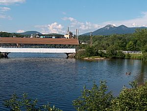
Covered bridge over the Upper Ammonoosuc River
|
|

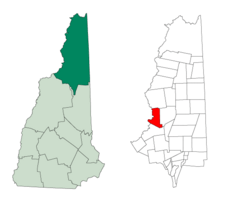
Location in Coös County, New Hampshire
|
|
| Country | United States |
| State | New Hampshire |
| County | Coös |
| Incorporated | 1779 |
| Villages | Groveton Northumberland |
| Area | |
| • Total | 36.78 sq mi (95.25 km2) |
| • Land | 35.69 sq mi (92.43 km2) |
| • Water | 1.09 sq mi (2.82 km2) 2.96% |
| Elevation | 860 ft (260 m) |
| Population
(2020)
|
|
| • Total | 2,126 |
| • Density | 60/sq mi (23.0/km2) |
| Time zone | UTC-5 (Eastern) |
| • Summer (DST) | UTC-4 (Eastern) |
| ZIP code | |
| Area code(s) | 603 |
| FIPS code | 33-56100 |
| GNIS feature ID | 0873688 |
Northumberland is a town in New Hampshire, located in the western part of Coös County. It is north of Lancaster. This town is part of the Berlin, NH–VT area. In 2020, about 2,126 people lived here. A little over half of them, 1,068 people, lived in the village of Groveton.
Contents
History of Northumberland
Northumberland has a long and interesting history.
Early Settlements and Forts
Near the Connecticut River, you can find the remains of Fort Wentworth. This fort was built in 1755 by the New Hampshire Militia. It was used during the French and Indian War, a big conflict between Great Britain and France, along with their Native American allies.
The town was first called Stonington in 1761. It was given to John Hogg and others by Governor Benning Wentworth. The first people to settle here were Thomas Burnside and Daniel Spaulding in 1767.
Naming the Town
Later, in 1771, Governor John Wentworth gave the town a new name: Northumberland. This name came from a place in England called Northumberland. The town officially became a town (was incorporated) on November 16, 1779.
Railroad and Economy
Groveton is an important spot for railroads. It's where the New Hampshire & Vermont Railroad meets the St. Lawrence & Atlantic Railroad. This used to be a major meeting point for two other big railroads, the Grand Trunk Railway and the Boston, Concord & Montreal Railroad. It was a key way to get to the northern White Mountains.
In the past, Northumberland was known for growing a lot of corn and potatoes. It also had mills that made starch and factories that produced things like leather and shoe pegs. More recently, the town's economy mostly relied on the lumber industry. However, this changed in 2007 when the Wausau Paper Mill closed. This meant about 300 people lost their jobs.
Geography of Northumberland
Northumberland covers about 36.5 square miles (95.25 square kilometers). Most of this area is land, about 35.7 square miles (92.43 square kilometers), and a smaller part is water, about 0.8 square miles (2.82 square kilometers).
Rivers and Mountains
The Connecticut River flows along the western side of the town. This river also forms the border between New Hampshire and Vermont. The Upper Ammonoosuc River also runs through Northumberland, heading southwest towards the Connecticut River. You can see a covered bridge over this river in Groveton.
Northumberland has several mountains. Some of them include:
- Morse Mountain, which is about 1,880 feet (573 meters) above sea level.
- Cape Horn, standing at about 2,040 feet (622 meters) above sea level.
- Moore Mountain, which is about 1,522 feet (464 meters) above sea level.
- Spaulding Hill, about 1,220 feet (372 meters) above sea level.
The highest point in town is about 2,860 feet (872 meters) above sea level. It's located on a part of the Pilot Range, on the eastern edge of the town.
Forests and Roads
Cape Horn State Forest is located in the middle of Northumberland.
The main part of Northumberland, outside of Groveton, is located along US 3. This road runs along the Connecticut River. Another road, Route 110, crosses US 3 in Northumberland and goes east towards the nearby town of Stark.
Population of Northumberland
| Historical population | |||
|---|---|---|---|
| Census | Pop. | %± | |
| 1790 | 117 | — | |
| 1800 | 205 | 75.2% | |
| 1810 | 281 | 37.1% | |
| 1820 | 205 | −27.0% | |
| 1830 | 342 | 66.8% | |
| 1840 | 399 | 16.7% | |
| 1850 | 429 | 7.5% | |
| 1860 | 736 | 71.6% | |
| 1870 | 955 | 29.8% | |
| 1880 | 1,062 | 11.2% | |
| 1890 | 1,356 | 27.7% | |
| 1900 | 1,977 | 45.8% | |
| 1910 | 2,184 | 10.5% | |
| 1920 | 2,567 | 17.5% | |
| 1930 | 2,360 | −8.1% | |
| 1940 | 2,740 | 16.1% | |
| 1950 | 2,779 | 1.4% | |
| 1960 | 2,586 | −6.9% | |
| 1970 | 2,493 | −3.6% | |
| 1980 | 2,520 | 1.1% | |
| 1990 | 2,492 | −1.1% | |
| 2000 | 2,438 | −2.2% | |
| 2010 | 2,288 | −6.2% | |
| 2020 | 2,126 | −7.1% | |
| U.S. Decennial Census | |||
In 2000, there were 2,438 people living in Northumberland. There were 989 households, which are groups of people living together in one home. Most of the people living in the town were White. A small number of people were Native American, Asian, or from two or more races.
About 32.3% of the households had children under 18 living with them. Many households were married couples living together. The average household had about 2.47 people.
The population was spread out in terms of age. About 26.2% of the people were under 18 years old. About 15.8% were 65 years old or older. The average age in town was 38 years.
Places to Visit
- Groveton Covered Bridge
Notable Person
- William E. Holyoke (1868–1934), a US Navy sailor who received the Medal of Honor.
See also
 In Spanish: Northumberland (Nuevo Hampshire) para niños
 | Dorothy Vaughan |
 | Charles Henry Turner |
 | Hildrus Poindexter |
 | Henry Cecil McBay |

