Norwood, New Jersey facts for kids
Quick facts for kids
Norwood, New Jersey
|
||
|---|---|---|
|
Borough
|
||
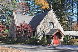
Church of the Holy Communion
|
||
|
||
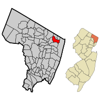
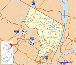
Location of Norwood in Bergen County highlighted in red (left). Inset map: Location of Bergen County in New Jersey highlighted in orange (right).
|
||
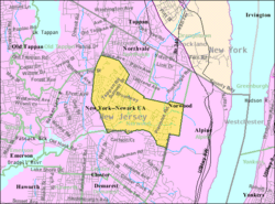
Census Bureau map of Norwood, New Jersey
|
||
| Country | ||
| State | ||
| County | Bergen | |
| Incorporated | March 21, 1905 | |
| Named for | "North-woods" | |
| Government | ||
| • Type | Borough | |
| • Body | Borough Council | |
| Area | ||
| • Total | 2.79 sq mi (7.24 km2) | |
| • Land | 2.79 sq mi (7.21 km2) | |
| • Water | 0.01 sq mi (0.02 km2) 0.32% | |
| Area rank | 355th of 565 in state 32nd of 70 in county |
|
| Elevation | 30 ft (9 m) | |
| Population
(2020)
|
||
| • Total | 5,641 | |
| • Estimate
(2023)
|
5,729 | |
| • Rank | 361st of 565 in state 58th of 70 in county |
|
| • Density | 2,025.5/sq mi (782.0/km2) | |
| • Density rank | 295th of 565 in state 57th of 70 in county |
|
| Time zone | UTC−05:00 (Eastern (EST)) | |
| • Summer (DST) | UTC−04:00 (Eastern (EDT)) | |
| ZIP Code |
07648
|
|
| Area code(s) | 201 exchanges: 750, 767, 768, 784 | |
| FIPS code | 3400353610 | |
| GNIS feature ID | 0885329 | |
| Website | ||
Norwood is a small town, called a borough, located in Bergen County, in the state of New Jersey. In 2020, about 5,641 people lived here. Norwood became an official borough on March 14, 1905. It was created from parts of Harrington Township.
Contents
History of Norwood
Early Settlements and Native Americans
The area that is now Norwood was first settled around 1686. About a dozen families, mostly from the Dutch Republic, bought the land. This happened under a special agreement called the Tappan Patent. Around the same time, Philip Carteret, who was the Governor of East Jersey, also gave a land grant. The Lenape, a Native American tribe, used to live and travel through this valley.
How Norwood Got Its Name
The name Norwood comes from how the area was described long ago: the "North-Woods." It was part of Harrington Township. This larger township was formed in 1775 from the northern parts of Hackensack Township and New Barbadoes Township. Harrington Township stretched from the Hudson River in the east to the Saddle River in the west.
Changes to the Township
In 1840, parts of Harrington Township west of the Hackensack River were used to create Washington Township. At that time, Harrington Township was shaped like a square, about 5 miles (8.0 km) on each side. It was bordered by Rockland County, New York to the north, the Hudson River to the east, Hackensack Township to the south, and the Hackensack River to the west. Norwood, along with Northvale, Old Tappan, Demarest, Closter, and Harrington Park, were all communities within Harrington Township.
Becoming an Independent Borough
On March 14, 1905, Norwood officially separated from Harrington Township. It became its own independent borough.
Geography and Location
Norwood's Size and Borders
Norwood covers a total area of about 2.79 square miles (7.24 km2). Most of this is land, with only a tiny bit of water.
Norwood is in the northeastern part of New Jersey. It is about 2 miles (3.2 km) from the border with New York state. Norwood shares its borders with several other towns in Bergen County. These include Alpine, Closter, Harrington Park, Northvale, Old Tappan, and Rockleigh.
A smaller area within the borough is known as West Norwood.
Population and People
Population Changes Over Time
| Historical population | |||
|---|---|---|---|
| Census | Pop. | %± | |
| 1900 | 400 | — | |
| 1910 | 564 | 41.0% | |
| 1920 | 820 | 45.4% | |
| 1930 | 1,358 | 65.6% | |
| 1940 | 1,512 | 11.3% | |
| 1950 | 1,792 | 18.5% | |
| 1960 | 2,852 | 59.2% | |
| 1970 | 4,398 | 54.2% | |
| 1980 | 4,413 | 0.3% | |
| 1990 | 4,858 | 10.1% | |
| 2000 | 5,751 | 18.4% | |
| 2010 | 5,711 | −0.7% | |
| 2020 | 5,641 | −1.2% | |
| 2023 (est.) | 5,729 | 0.3% | |
| Population sources: 1910–1930 1900–2020 2000 2010 2020 |
|||
In 2010, there were 5,711 people living in Norwood. The population density was about 2,093.5 people per square mile. Most residents (69.25%) were White. About 27.18% were Asian, and 1.37% were Black or African American. People of Hispanic or Latino background made up 4.55% of the population. A large number of residents, 20.1%, were Korean Americans.
Households and Families
In 2010, there were 1,927 households in Norwood. About 36.8% of these households had children under 18. Most households (67.8%) were married couples living together. The average household had 2.84 people, and the average family had 3.23 people.
The median age in Norwood in 2010 was 46.1 years. About 23.1% of the population was under 18. About 20.0% were 65 years or older.
Local Government
How Norwood is Governed
Norwood uses the borough form of government, which is common in New Jersey. The government is made up of a mayor and a borough council. All these positions are chosen by voters in the November general election.
The mayor is elected for a four-year term. The borough council has six members. They serve three-year terms, with two seats up for election each year. Norwood has a "weak mayor / strong council" government. This means the council members make the laws. The mayor leads meetings and only votes if there is a tie. The mayor can also reject new laws, but the council can overrule this with a two-thirds vote. The mayor also assigns council members to different committees.
Current Leaders
As of 2023, the mayor of Norwood is James P. Barsa from the Republican party. His term ended on December 31, 2023. The members of the Borough Council are:
- Council President Annie Hausman (Democrat, term ended 2023)
- Joseph Ascolese (Republican, term ends 2024)
- Thomas L. Brizzolara (Democrat, term ends 2024)
- Edward P. Condoleo (Republican, term ends 2025)
- Anthony Foschino (Republican, term ends 2025)
- Bong June "BJ" Kim (Republican, term ended 2023)
Education in Norwood
Local Schools
The Norwood Public School District serves students from kindergarten through eighth grade. All these students attend Norwood Public School. In the 2018–19 school year, the school had 618 students and 48.5 teachers. This means there were about 12.7 students for every teacher.
High School Education
Students in public school from ninth through twelfth grade attend Northern Valley Regional High School at Old Tappan. Students from Harrington Park, Northvale, and Old Tappan also go to this school. Students from Rockleigh attend through a special agreement.
This high school is one of two schools in the Northern Valley Regional High School District. The other school is Northern Valley Regional High School at Demarest. In the 2018–19 school year, Northern Valley Regional High School at Old Tappan had 1,170 students and 97.9 teachers. This means there were about 12 students for every teacher. The school was recognized with the Blue Ribbon School Award of Excellence in the mid-1990s.
Norwood has one seat on the high school district's nine-member board of education.
Specialized Programs
Students from Norwood, and all of Bergen County, can also attend special high school programs. These are offered by the Bergen County Technical Schools. These include the Bergen County Academies in Hackensack. They also include the Bergen Tech campus in Teterboro or Paramus. These programs can be full-time or part-time. Students must apply and be accepted, and their home school district covers the tuition.
Transportation
Roads and Highways
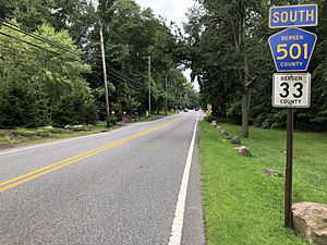
As of 2010, Norwood had about 25.31 miles (40.73 km) of roads. The town itself maintained 18.27 miles (29.40 km) of these roads. Bergen County maintained the remaining 7.04 miles (11.33 km).
Two main county roads pass through Norwood. CR 501 runs for about 1 mile (1.6 km). CR 505 runs for about 1.3 miles (2.1 km).
Public Transportation
Rockland Coaches provides bus service in Norwood. Their routes 20/20T go to the Port Authority Bus Terminal in New York City.
Wildlife in Norwood
The forests in Norwood are home to many types of trees. These forests provide shelter for various animals. You might see deer, wild turkeys, turtles, foxes, rabbits, and coyotes.
However, as more buildings are constructed, suburban areas are expanding. This growth is starting to affect the local wildlife. For example, there have been issues with deer getting into car accidents. Also, coyotes are sometimes seen interacting with people.
Notable People
Many interesting people have lived in or are connected to Norwood:
- Kenny Anderson (born 1970), a basketball player who started his NBA career with the New Jersey Nets.
- Ray Barretto (1929–2006), a famous percussionist and bandleader.
- Colleen Broomall (born 1983), an actress and journalist.
- Devin Fuller (born 1994), a wide receiver who played for the Atlanta Falcons in the National Football League.
- Jordan Fuller (born 1998), an American football safety for the Los Angeles Rams.
- Bruce Harper (born 1955), a former running back for the New York Jets.
- Catfish Hunter (1946–1999), a pitcher who played for the Kansas City / Oakland A's and New York Yankees.
- Don Mattingly (born 1961), a manager for the Los Angeles Dodgers. He lived in Norwood when he played for the New York Yankees.
- Bob McGrath (1932–2022), an actor, singer, and children's author. He was best known as Bob Johnson on Sesame Street.
- Gene Michael (1938–2017), a former baseball player, manager, and executive.
- Thurman Munson (1947–1979), a former baseball player who was a catcher for the New York Yankees.
- Graig Nettles (born 1944), a former baseball player who played third base for the New York Yankees.
- Dianna Russini (born 1983), a sports journalist for ESPN.
- Pamela Redmond Satran (born 1953), an author.
- Abi Varghese, a director and writer, known for his show Brown Nation on Netflix.
See also
 In Spanish: Norwood (Nueva Jersey) para niños
 | William L. Dawson |
 | W. E. B. Du Bois |
 | Harry Belafonte |


