Pangkalpinang facts for kids
Quick facts for kids
Pangkalpinang
|
|||
|---|---|---|---|
|
City and provincial capital
|
|||
| City of Pangkalpinang Kota Pangkalpinang |
|||
| Regional transcription(s) | |||
| • Jawi | ڤڠكل ڤينڠ | ||
|
Pangkalpinang city view
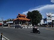
Fuk Tet Che Temple
Wilhelmina Park
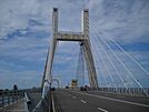
Emas Bridge
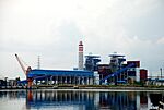
Air Anyir Power Plant
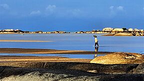
Batu Bolong Beach
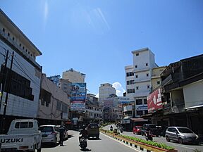
Street view
|
|||
|
|||
| Motto(s): | |||
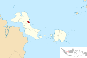
Location within Bangka Belitung Islands
|
|||
| Country | |||
| Region | Sumatra | ||
| Province | |||
| Founded | 17 September 1757 | ||
| Area | |||
| • Total | 104.54 km2 (40.36 sq mi) | ||
| Elevation | 0-13 m (−42.7 ft) | ||
| Population
(mid 2022 estimate)
|
|||
| • Total | 226,297 | ||
| • Density | 2,164.69/km2 (5,606.53/sq mi) | ||
| Demographics | |||
| • Ethnic groups | Malay Javanese Batak, Chinese Bugis |
||
| • Religion | Islam 52.31% Buddhism 36.18% Confucianism 4.56% Christian 3.41% Catholic 3.21% Hinduism 0.04% Others 0.27% |
||
| • Languages | Indonesian (official) Chinese Malay English (regional) |
||
| Time zone | UTC+7 (Indonesia Western Time) | ||
| Area code | (+62) 717 | ||
| Vehicle registration | BN | ||
| Pangkalpinang | |||||||||||||||||||||
|---|---|---|---|---|---|---|---|---|---|---|---|---|---|---|---|---|---|---|---|---|---|
| Traditional Chinese | 邦加檳港 | ||||||||||||||||||||
| Simplified Chinese | 邦加槟港 | ||||||||||||||||||||
|
|||||||||||||||||||||
Pangkalpinang, also known as Pangkal Pinang, is the main city and capital of the Bangka Belitung Islands Province in Indonesia. It is located on the east coast of Bangka Island. The city is divided into seven areas called districts, which have 42 smaller parts called wards.
Pangkalpinang covers an area of about 104.54 square kilometers. In mid-2022, about 226,297 people lived there. This means there were about 2,165 people per square kilometer. The Rangkui River flows through the city, dividing it into two parts. Jalan Merdeka is considered the city's center.
Most of the people in Pangkalpinang are ethnic Malays and Hakka Chinese. There are also smaller groups of people from other places, like Batak and Minangkabau. Important places to visit in the city include the Timah Museum, a Chinese temple, the Cathedral of St. Joseph, the Bangka Botanical Garden, and Pasir Padi beach.
Contents
- What Does Pangkalpinang Mean?
- A Look at Pangkalpinang's Past
- Who Lives in Pangkalpinang?
- Pangkalpinang's Landscape
- Pangkalpinang's Weather
- City Districts
- Fun Things to See and Do
- What to Eat in Pangkalpinang
- Getting Around Pangkalpinang
- Pangkalpinang's Economy
- Famous People From Pangkalpinang
- Sister City
- See also
What Does Pangkalpinang Mean?
The name Pangkalpinang comes from two local words. Pengkal means "base" and pinang refers to the Areca catechu palm tree. This type of palm tree grows a lot on Bangka Island.
A Look at Pangkalpinang's Past
Early History
Long ago, Pangkalpinang was part of old kingdoms like Srivijaya, Majapahit, and the Mataram Kingdom. Even though it was close to important shipping routes, it didn't get much attention. Because of this, it became a hiding spot for pirates who attacked ships in the South China Sea.
To stop the pirates, the Johor Sultanate sent soldiers to Pangkalpinang. They also helped spread the religion of Islam in the area. But the pirates kept coming back. Later, the Sultan of Banten sent a leader to get rid of the pirates for good. This leader controlled Bangka until he passed away. His daughter then took over.
Colonial Times
Around 1709, a valuable metal called tin was found near the Olin River. This discovery brought many traders, including those from China, to the area. The Sultan of Palembang even asked China for experts in tin mining. In 1717, the Palembang Sultanate started trading with the Dutch East India Company (VOC). With their help, the sultan tried to stop piracy and illegal tin trading.
During the Napoleonic Wars, France took over the Netherlands. Because of this, the British took control of all Dutch areas in Indonesia. In 1811, the Dutch handed over Java, Timor, Makassar, and Palembang to the British. This meant Pangkalpinang became a British colony. The British leader, Stamford Raffles, wanted the tin mines in Pangkalpinang.
In 1812, the British sent an expedition to Palembang. They replaced the local sultan with a new one, who then gave the islands of Belitung and Bangka Island to the British.
Later, in 1824, the Netherlands got back the areas the British had taken, including Pangkalpinang. Both the Dutch and British treated the local people unfairly. They forced them to work and took advantage of them. The Dutch especially wanted the tin. The local people fought back against the Dutch in many places, including Pangkalpinang.
During World War II, Japanese soldiers took over Bangka Island. Even though they were there for a short time, there was a serious lack of food and clothes.
Becoming Independent
After Japan lost the war and Indonesia became independent, Pangkalpinang became part of Indonesia. At first, it was part of the South Sumatra province. Later, the Bangka Belitung Islands became their own province, and Pangkalpinang was chosen as its capital.
Who Lives in Pangkalpinang?
The number of people living in Pangkalpinang has grown over the years. In 1990, there were about 108,411 people. By mid-2022, the number had reached around 226,297.
About half of the people are Malay, and they mostly speak a local language called Bangka Malay. The other half are Chinese. Their ancestors came from China's Guangdong province in the 1700s. These Chinese people are known locally as Peranakan, which means "Children of the Indies." They mostly speak the Hakka language. A small group also speaks Cantonese.
The biggest religion in Pangkalpinang is Islam. Most Chinese people follow Buddhism and Christianity. A smaller number follow Taoism and Confucianism.
Pangkalpinang's Landscape
Land Features
Pangkalpinang has a landscape with rolling hills. The city is usually between 20 and 50 meters above sea level. The hilliest parts are in the west and south. This includes Mount Girimaya, which is 50 meters high, and Tower Hill.
There is a large urban forest covering 290 hectares in the Old Village area. About 1,562 hectares of land are used for growing food, fishing, and forestry. Another 1,163 hectares are unused land, and 4,130 hectares are developed areas. The rest, about 2,085 hectares, are swamps and forests.
Soil and Rocks
The soil in Pangkalpinang is usually acidic, with an average pH below 5. It is mostly red-yellow podzolic soil and regosol. Some areas have bog soil and light-gray regosol, which come from sand and clay deposits. This type of soil is not ideal for growing rice, but other crops can be grown there.
The oldest rocks in the city are limestone from the Permo-Carboniferous period. There are also slate rocks from the Late Triassic period and granite from the Triassic-Jurassic periods. The granite rocks often contain dark-colored minerals like biotite and amphibole.
Rivers and Water
The Rangkui River flows through the city. The Pedindang River is in the south. Both of these rivers flow into the Baturusa River, which then goes into the South China Sea. In the past, these rivers were important for transporting goods to markets. However, they also make Pangkalpinang likely to flood, especially during the rainy season or when the tide is high.
Pangkalpinang's Weather
Pangkalpinang has a tropical rainforest climate. This means it gets a lot of rain all year round. The rain is usually much heavier from November to April.
| Climate data for Pangkalpinang (Depati Amir Airport, 1991–2020 normals) | |||||||||||||
|---|---|---|---|---|---|---|---|---|---|---|---|---|---|
| Month | Jan | Feb | Mar | Apr | May | Jun | Jul | Aug | Sep | Oct | Nov | Dec | Year |
| Record high °C (°F) | 34.8 (94.6) |
33.8 (92.8) |
34.3 (93.7) |
34.4 (93.9) |
35.0 (95.0) |
34.4 (93.9) |
34.0 (93.2) |
33.9 (93.0) |
35.9 (96.6) |
36.1 (97.0) |
34.9 (94.8) |
34.4 (93.9) |
36.1 (97.0) |
| Mean daily maximum °C (°F) | 30.2 (86.4) |
30.6 (87.1) |
31.2 (88.2) |
31.6 (88.9) |
31.8 (89.2) |
31.5 (88.7) |
31.3 (88.3) |
31.6 (88.9) |
32.0 (89.6) |
31.9 (89.4) |
31.3 (88.3) |
30.3 (86.5) |
31.3 (88.3) |
| Daily mean °C (°F) | 26.1 (79.0) |
26.3 (79.3) |
26.5 (79.7) |
26.9 (80.4) |
27.5 (81.5) |
27.4 (81.3) |
27.2 (81.0) |
27.4 (81.3) |
27.5 (81.5) |
27.3 (81.1) |
26.8 (80.2) |
26.2 (79.2) |
26.9 (80.4) |
| Mean daily minimum °C (°F) | 23.5 (74.3) |
23.5 (74.3) |
23.6 (74.5) |
23.9 (75.0) |
24.5 (76.1) |
24.4 (75.9) |
24.1 (75.4) |
24.1 (75.4) |
24.1 (75.4) |
24.0 (75.2) |
23.8 (74.8) |
23.5 (74.3) |
23.9 (75.0) |
| Record low °C (°F) | 19.6 (67.3) |
19.0 (66.2) |
19.8 (67.6) |
20.2 (68.4) |
20.4 (68.7) |
21.5 (70.7) |
21.0 (69.8) |
21.0 (69.8) |
21.4 (70.5) |
21.0 (69.8) |
21.1 (70.0) |
19.8 (67.6) |
19.0 (66.2) |
| Average precipitation mm (inches) | 284.4 (11.20) |
233.3 (9.19) |
258.9 (10.19) |
244.7 (9.63) |
207.6 (8.17) |
135.4 (5.33) |
131.4 (5.17) |
104.8 (4.13) |
100.3 (3.95) |
169.3 (6.67) |
226.8 (8.93) |
296.1 (11.66) |
2,393 (94.21) |
| Average precipitation days (≥ 1.0 mm) | 18.3 | 13.3 | 16.2 | 15.6 | 14.4 | 11.7 | 10.9 | 7.5 | 7.7 | 11.4 | 16.2 | 19.2 | 162.4 |
| Source: World Meteorological Organization | |||||||||||||
City Districts
Pangkalpinang is divided into seven districts. Each district has several smaller parts called kelurahan (wards). Here's a table showing the districts, their sizes, and how many people lived there in different years:
| Kode Wilayah |
Name of District (kecamatan) |
Area in km2 |
Pop'n Census 2010 |
Pop'n Census 2020 |
Pop'n Estimate mid 2022 |
Admin centre |
No. of kelurahan |
Post codes |
|---|---|---|---|---|---|---|---|---|
| 19.71.04 | Rangkui | 5.04 | 39,938 | 35,703 | 36,965 | Keramat | 8 | 33132 - 33139 |
| 19.71.01 | Bukit Intan | 35.42 | 43,325 | 41,343 | 42,805 | Air Itam | 7 | 33147 - 33149 |
| 19.71.07 | Girimaya | 4.50 | (a) | 18,129 | 18,770 | Sriwijaya | 5 | 33141 - 33146 |
| 19.71.03 | Pangkal Balam | 4.72 | 41,055 | 22,142 | 22,925 | Kotapang | 5 | 33111 - 33115 |
| 19.71.06 | Gabek | 20.39 | (a) | 35,013 | 36,251 | Gabek Dua | 6 | 33111 - 33119 |
| 19.71.02 | Taman Sari | 3.19 | 13,117 | 18,473 | 19,126 | Gedung Nasional | 5 | 33121 - 33127 |
| 19.71.05 | Gerunggang | 31.14 | 37,323 | 47,766 | 49,455 | Bukit Merapin | 6 | 33123 - 33125 |
| Totals | 104.41 | 174,758 | 218,569 | 226,297 | 42 |
Notes: (a) The population numbers for Girimaya and Gabek districts in 2010 are included in the districts they were part of before they became separate.
Fun Things to See and Do
Local Traditions and Festivals
- Nganggung is a special tradition where people share food. It usually happens during religious holidays like Lebaran and Eid al-Adha.
- The Qingming Festival, also called Ceng Beng by local Chinese people, is also celebrated. It's a time to remember ancestors.
Important Buildings and Places
- Tin Museum: This is the only tin museum in Asia. It's also where an important agreement about Indonesia's independence was signed on May 7, 1949.
- Jamik Mosque: Built in 1936, this is one of the biggest and oldest mosques in Pangkalpinang. You can find it on Jalan Masjid Jamik.
- Kwan Tie Miaw Temple: Located on Jalan Mayor Muhidin, this is one of the oldest temples on Bangka Island. It was built around 1841 and is dedicated to Lord Guan.
- GPIB Maranatha Church: This church was built in 1927. After Indonesia became independent, its name was changed to Western Indonesian Protestant Church (GPIB) Maranatha Pangkalpinang.
What to Eat in Pangkalpinang
- Tai Fu Sui (also called fu sui) is a popular drink that tastes similar to soy milk.
- Pantiaw or kwetiaw is a dish made from sago and rice flour. It's usually served with fish soup.
Getting Around Pangkalpinang
Public Transport
- Angkots are small public vans used for getting around the city and nearby areas.
By Air
- Depati Amir Airport is the airport for Bangka Belitung. It has daily flights to major cities like Jakarta, Palembang, Tanjungpandan, Surabaya, and Batam. Airlines like Garuda Indonesia, Citilink, Lion Air, and Sriwijaya Air fly there. A new airport terminal opened in 2017. It can handle 1.5 million passengers each year.
By Sea
- Pangkal Balam is the city's main seaport. It handles daily exports and imports, trade between islands, and passenger travel to and from Jakarta and Tanjungpandan. Smaller seaports, like Muntok, have speedboats that go to and from Palembang.
Pangkalpinang's Economy
The city's economy mainly relies on farm products. This includes food crops, raising animals, and fishing in the sea and freshwater. There are also small farms that grow rubber, pepper, and coconuts. Pangkalpinang also has a beautiful beach that attracts visitors.
Famous People From Pangkalpinang
- Artika Sari Devi: She was crowned Puteri Indonesia in 2004 and was in the Top 15 at Miss Universe 2005. She is also an actress, model, and spokesperson.
- Sandra Dewi: A well-known actress and model.
- Natasha Mannuela Halim: She won Miss Indonesia 2016 and was the 2nd Runner-Up at Miss World 2016. She also won the Beauty with a Purpose award and is an actress and model.
- Sonia Fergina Citra: She was Puteri Indonesia 2018 and made it to the Top 20 at Miss Universe 2018. She is also a model.
Sister City
Pangkalpinang has a sister city relationship with:
See also
 In Spanish: Pangkal Pinang para niños


