Park County, Montana facts for kids
Quick facts for kids
Park County
|
|
|---|---|

|
|

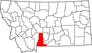
Location within the U.S. state of Montana
|
|
 Montana's location within the U.S. |
|
| Country | |
| State | |
| Founded | February 23, 1887 |
| Seat | Livingston |
| Largest city | Livingston |
| Area | |
| • Total | 2,813 sq mi (7,290 km2) |
| • Land | 2,803 sq mi (7,260 km2) |
| • Water | 10 sq mi (30 km2) 0.4% |
| Population
(2020)
|
|
| • Total | 17,191 |
| • Estimate
(2022)
|
17,790 |
| • Density | 6.1113/sq mi (2.3596/km2) |
| Time zone | UTC−7 (Mountain) |
| • Summer (DST) | UTC−6 (MDT) |
| Area code | 406 |
| Congressional district | 2nd |
|
|
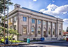
Park County is a county in the state of Montana, USA. It is known for its beautiful nature. A small part of Yellowstone National Park is in the southern part of the county. In 2020, about 17,191 people lived here. Its main town, or county seat, is Livingston.
Contents
History of Park County
Park County was officially created on February 23, 1887, by the government of Montana Territory. It was named "Park County" because it is very close to Yellowstone National Park. Part of the park is even inside the county today!
Early People and Explorers
For a very long time, this area was home to many Native American tribes. These included the Crow, Sioux, and Blackfoot tribes, who hunted and lived here. The first time people of European descent visited this area was during the famous Lewis and Clark Expedition in 1805. Later, a mountain man named Jim Bridger spent a winter with Crow nomads near what is now Emigrant in 1844–45.
Gold and New Trails
Many hunters and trappers traveled through this area in the early 1800s. However, by 1850, the number of beavers had almost disappeared. Gold was found in Emigrant Gulch in 1863. By 1864, a busy town had grown up to serve the miners. This town, called Yellowstone City, had 75 cabins and was very active.
In 1864, two miners, John Bozeman and John Jacobs, created the Bozeman Trail. This trail helped people travel to western Montana Territory. It quickly became a popular route between Fort Laramie and western Montana. The trail passed through the area where Livingston is now, heading towards Bozeman Pass. By the late 1860s, many people were also arriving and leaving by boat on the Yellowstone River. They used a special spot in the Livingston area.
Settlement and Protection
As more settlers arrived, the Native American tribes were pushed out of their traditional lands. This caused problems, so in the late 1860s, the governor of the territory, Green Clay Smith, created a group of 600 soldiers. This group camped at Fort Howie, near the mouth of the Shields River, about 5 miles (8 km) east of present-day Livingston, to protect the area.
In 1868, a special agency for Native Americans was set up on the Crow Reservation. It included a strong, fortified building at Mission Creek, southeast of Livingston. A ferry service was started to cross the Yellowstone River to the fort. This ferry was about 4 miles (6 km) east of present-day Livingston. A small town called Benson's Landing grew around this ferry landing. It was a busy community for several decades.
Growth and the Railroad
People became more interested in the Yellowstone Park area around 1870. By 1872, the United States government made it the country's first national park. By 1880, about 200 people lived in the area that would become Park County.
In 1881, the Northern Pacific Railway entered Montana Territory. By November 22, 1882, the railroad line reached Livingston, which then had about 500 residents. In 1883, a special branch of the Northern Pacific railroad was finished, leading to the National Park. That same year, the main east-west line of the Northern Pacific was completed. This opened up the northern part of the country for trade and settlement. The local population grew very quickly. By 1887, the territorial government had approved the creation of Park County. By 1890, the county's population had reached 6,900 people.
Geography of Park County
Park County covers an area of about 2,813 square miles (7,286 km²). Most of this, about 2,803 square miles (7,260 km²), is land. Only about 10 square miles (26 km²) is water.
Highest Point
The highest natural point in all of Montana is Granite Peak. It stands at 12,807 feet (3,904 meters) tall and is located in Park County.
County Boundaries
Park County got its current shape in 1978. Before that, a part of Yellowstone National Park was considered its own separate area. This area was then divided between Gallatin County and Park County. Park County received about 146 square miles (379 km²) of land and a small amount of water from this change.
Major Highways
Transit Options
- Jefferson Lines
Neighboring Counties
- Gallatin County – to the west
- Meagher County – to the north
- Sweet Grass County – to the east
- Stillwater County – to the southeast
- Carbon County – to the southeast
- Park County, Wyoming – to the south
Protected Natural Areas
- Custer National Forest (part)
- Gallatin National Forest (part)
- Lewis and Clark National Forest (part)
- Yellowstone National Park (part)
Population Data
| Historical population | |||
|---|---|---|---|
| Census | Pop. | %± | |
| 1890 | 6,881 | — | |
| 1900 | 7,341 | 6.7% | |
| 1910 | 10,731 | 46.2% | |
| 1920 | 11,330 | 5.6% | |
| 1930 | 10,922 | −3.6% | |
| 1940 | 11,566 | 5.9% | |
| 1950 | 11,999 | 3.7% | |
| 1960 | 13,168 | 9.7% | |
| 1970 | 11,197 | −15.0% | |
| 1980 | 12,869 | 14.9% | |
| 1990 | 14,562 | 13.2% | |
| 2000 | 15,694 | 7.8% | |
| 2010 | 15,636 | −0.4% | |
| 2020 | 17,191 | 9.9% | |
| 2022 (est.) | 17,790 | 13.8% | |
| U.S. Decennial Census 1790–1960 1900–1990 1990–2000 2010–2020 |
|||
2020 Census Information
According to the 2020 census, there were 17,191 people living in Park County.
2010 Census Information
In the 2010 census, Park County had 15,636 people. There were 7,310 households and 4,177 families living in the county. The average age of people in the county was 45.4 years old.
Communities in Park County
City
- Livingston (This is the county seat, where the main government offices are.)
Town
- Clyde Park
Census-Designated Places
These are areas that are like towns but are not officially incorporated as cities or towns.
Other Unincorporated Communities
These are smaller settlements that are not officially recognized as towns or cities.
- Brisbin
- Carbella
- Chadborn
- Chico
- Chimney Rock
- Contact
- Grannis
- Hoppers
- Hunters Hot Springs
- Independence
- Kotke
- Miner
- Sphinx
- White City
Ghost Town
- Aldridge (A ghost town is a town that has been abandoned.)
Education in Park County
Park County has several school districts that serve its students.
School Districts
- Gardiner Public Schools has two parts: Gardiner Elementary School District and Gardiner High School District.
- Livingston Public Schools also has two parts: Livingston Elementary School District and Park High School District.
- Shields Valley Public Schools has two parts: Shields Valley Elementary School District and Shields Valley High School District.
High School Districts
- Gardiner High School District
- Park High School District
- Shields Valley High School District
Elementary School Districts
- Arrowhead Elementary School District
- Cooke City Elementary School District
- Gardiner Elementary School District
- Livingston Elementary School District
- Pine Creek Elementary School District
- Shields Valley Elementary School District
See also
 In Spanish: Condado de Park (Montana) para niños
 | Calvin Brent |
 | Walter T. Bailey |
 | Martha Cassell Thompson |
 | Alberta Jeannette Cassell |

