Pinal Mountains facts for kids
Quick facts for kids Pinal Mountains |
|
|---|---|

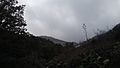
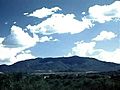
View of the Pinal Mountains from atop Round Mountain north of Globe, Arizona (facing South)
|
|
| Highest point | |
| Peak | Pinal Peak |
| Elevation | 7,848 ft (2,392 m) [1] |
| Prominence | 4,086 ft (1,245 m) [2] |
| Geography | |
| Location | Gila County, Arizona |
| State/Province | Arizona transition zone Tonto National Forest |
The Pinal Mountains are a cool mountain range in Gila County, Arizona. The Yavapai people call them Walkame, meaning "pine mountains". The Western Apache call them Dził Nnilchí' Diyiléé, which means "pine-burdened mountain".
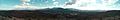
The highest point is Pinal Peak, which stands at 7,848 ft (2,392 m) tall. The mountains are very close to the cities of Globe, Arizona and Miami, Arizona. They are part of the Tonto National Forest. The United States Forest Service helps take care of the fun places to visit here.
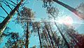
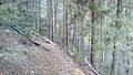
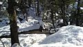
The San Carlos Apache Indian Reservation is also nearby. These mountains are covered with tall Ponderosa Pine and white fir trees. They are a popular spot for summer fun because the weather is much cooler than in the nearby towns. You can find dirt roads, campsites, and many hiking trails here. The Pinal Mountains cover a large area of 45,760 acres.
Contents
Where Are the Pinal Mountains Located?
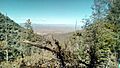
The entire Pinal Mountain range is in southern Gila County, Arizona. It is just a few miles south of the towns of Globe, Arizona and Miami, Arizona.

A Look Back: History of the Pinal Mountains
The area around the Pinal Mountains has a long and interesting history.
Early Native American Cultures
Around the 11th and 12th centuries, Pueblo-culture Native Americans lived here. This group is known as the Salado culture. They lived well in this area for many centuries. The Besh-Ba-Gowah ruins near Globe show that Salado people lived there from the 13th to 15th centuries.
However, in the mid-15th century, the Salado people left the area. They might have moved south and joined with the Pima people. Around the same time, the Western Apache and Kwevkepaya-Yavapai people began to settle in the area.
Names of the Mountains
The Apache people called the Pinal Mountains Dził Nnilchí' Diyiléé. This means "pine-burdened mountain". The Yavapai people called them Walkame, or "pine mountains".
Later, in the 17th century, Spanish explorers came to the region. They met the native peoples and learned about the mountains. The Spanish translated the native names into "Pinal", which means "stand of pine trees" in Spanish. There was even a short conflict between Spanish forces and Apache warriors here, known as the Battle of the Pinal Mountains.
Minerals and Mining in the Pinal Mountains
The Pinal Mountains have many different kinds of minerals. Some are precious, and some are not.
Mining History
From 1875 to the early 1900s, many mining claims were made in the Pinal Mountains. Miners found and dug up precious minerals like Copper, Silver, and small amounts of Gold. Other common minerals found here include Iron, Quartz, Calcite, Malachite, Azurite, Feldspar, Diorite, and Lead ores like Galena and Anglesite.
The most successful mine was the Gibson mine. It was located on the far western side of the mountains and was most active from 1906 to 1918. This mine produced almost all the copper and silver from the mountains. It yielded 12.5 million pounds of copper and 3,500 ounces of silver!
Mining Trails and Today
Many of the old mining trails higher up in the mountains became today's hiking trails. For example, the Sixshooter Canyon trail in the eastern part of the mountains was once a mining trail in the 1870s. Miners often carried six-shooters (a type of gun), which gave the canyon and trail their name. Today, there are no active mines in the Pinal Mountains. Most of the old mines have been completely dug out.
Plants and Animals: Flora and Fauna
The Pinal Mountains are home to a wide variety of plants and animals. Some species are found only in this area!
Unique and Common Plants
One special plant found here is the Arizona hedgehog cactus. Another is Senecio neomexicanus toumeyi, also called Toumey groundsel. Other common plants include ponderosa pine trees, white fir trees, juniper bushes, and Gambel oak trees.
Wildlife in the Mountains
You might spot many different animals in the Pinal Mountains. These include javelina, white-tailed deer, mule deer, cottontail rabbit, tree squirrel, and quail. Smaller creatures like the little brown bat also live here. Larger animals like the American black bear and mountain lion also call these mountains home.
Pinal Mountain Peaks
The Pinal Mountain range has four main peaks. These are listed by the official USGS survey map. All heights are official from the USGS.
Central Section Peaks
- Pinal Peak - 7,848 ft (2,392 m) tall.
- Signal Peak - 7,812 ft (2,381 m) tall.
Eastern Section Peak
- East Mountain (HP) - 6,892 ft (2,101 m) tall.
North-western Section Peak
- Madera Peak - 6,647 ft (2,026 m) tall.

Fun Things to Do: Recreation
The Pinal Mountains are a great place for outdoor fun, especially in the summer. People love the cooler weather and beautiful scenery. There are many trails and a campsite for visitors.
Hiking Trails
You can find at least 8 public hiking trails on Pinal Mountain. Two popular ones are Sixshooter Canyon Trail #197 and Icehouse Canyon Trail #198. Both are on the northeastern side of the mountain and can be reached by well-kept roads.
Campsite Fun

The Pinal Mountain recreation area also has a public campsite. It has 16 spots with picnic tables and fire-pit grills. There are also 4 bathrooms. The campsite is usually open from May to November, according to the USDA Forest Service. You can drive to the campsite on a well-maintained dirt road that goes all the way to the top of the mountain.
Images for kids
-
-
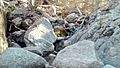
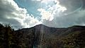
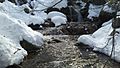
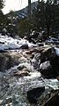
Small stream in the Pinal Mountains
-
-
-
-
-
-
-
-
-
-
-
-