
Point Roberts, Washington facts for kids
Quick facts for kids
Point Roberts, Washington
|
|
|---|---|
| Point Roberts | |
.jpeg)
Point Roberts cannery c. 1918
|
|
| Nickname(s):
The Point, Point Bob
|
|

Point Roberts, Washington
Location in Washington (state)

Point Roberts, Washington
Location in the United States

Point Roberts, Washington
Location in North America
|
|
| Country | United States |
| State | Washington |
| County | Whatcom |
| Established | June 15, 1846 |
| Area | |
| • Total | 4.884 sq mi (12.65 km2) |
| Elevation | 0 ft (0 m) |
| Population
(2020)
|
|
| • Total | 1,191 |
| • Estimate
(2022)
|
1,249 |
| • Density | 244/sq mi (94/km2) |
| Time zone | UTC−08:00 (PST) |
| • Summer (DST) | UTC−07:00 (PDT) |
| ZIP Code |
98281
|
| Area code(s) | 360 |
Point Roberts is a unique place in Washington. It is a small piece of land that is part of the United States but is cut off from the rest of the country. To reach it by land, you have to drive about 25 miles through Canada. You can also get there by boat or private plane.
This area is located on the southern tip of the Tsawwassen peninsula. It is south of Vancouver, British Columbia. In 2020, about 1,191 people lived there. Point Roberts has its own post office and a ZIP Code (98281).
Point Roberts became part of the U.S. in 1846. This happened when the United Kingdom and the United States decided on their border in the Pacific Northwest. They agreed that the 49th parallel would be the border. Since Point Roberts is south of this line, it became U.S. territory.
Contents
History of Point Roberts

The area around the Tsawwassen Peninsula was a favorite fishing spot for local Coast Salish groups. They called the peninsula "q̓ʷulƛ̕əl̕".
The first Europeans to see Point Roberts were explorers in 1791. Their maps showed it as "Isla de Cepeda". In 1792, British and Spanish expeditions met near Point Roberts. They realized it was not an island and renamed it Punta Cepeda.
Later, George Vancouver gave the area its current name, Point Roberts. He named it after his friend Henry Roberts.
-
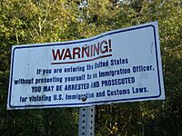
Notice at the international boundary between Canada and the United States in Point Roberts
-
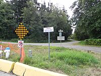
Boundary post in Point Roberts, Washington at the boundary between U.S. and Canada; photo taken at English Bluff Road, Delta facing Marine Drive, Point Roberts
-
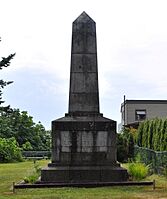
Boundary Marker No.1 on the 49th parallel north on the western shore of Point Roberts, erected in 1861


How Point Roberts Became U.S. Land
For many years, the U.S. and Britain both claimed the land in the Pacific Northwest. This area was called the Oregon Country. Some Americans wanted the U.S. to claim all the land up to 54°40′N latitude. This led to the slogan "Fifty-Four Forty or Fight".
Eventually, the U.S. and Britain agreed to use the 49th parallel as the border. This agreement was called the Oregon Treaty, signed on June 15, 1846.
When the border was surveyed, the British realized that Point Roberts would be cut off from the U.S. They asked if it could be part of Britain instead. They even offered to change the border slightly somewhere else. But the U.S. did not agree, and Point Roberts remained part of the United States.
Point Roberts and Canada
In 1858, during the Fraser Canyon Gold Rush, some gold prospectors briefly settled in Point Roberts. They called their small town "Robert's Town."
Over the years, there have been talks about Point Roberts joining Canada. In 1949, some people wanted it to secede from the U.S. and become part of Canada.
In 1973, a water shortage caused problems between U.S. and Canadian residents. Point Roberts now buys water from the Greater Vancouver Water District in Canada. The Delta Fire Department in Canada also helps the Point Roberts volunteer fire department when needed.
After the September 11 attacks in 2001, border security increased. This caused long delays for residents crossing the border.
During the COVID-19 pandemic, the Canadian border closed to non-essential travel. This made it very hard for Point Roberts residents to reach the rest of the U.S. Many businesses struggled, and the area was called a "ghost town". A temporary ferry service was set up to connect Point Roberts to the U.S. mainland. The border fully reopened in August 2021.
Because it was so isolated during the pandemic, Point Roberts was seen as a very safe place. It had very few cases of COVID-19.
Geography of Point Roberts

Point Roberts is a U.S. exclave. This means it is a piece of land that belongs to one country but is surrounded by another. In this case, Point Roberts is surrounded by Canada and the waters of Boundary Bay.
It is about 22 miles south of Downtown Vancouver, British Columbia. Point Roberts is part of the U.S. because it lies south of the 49th parallel. This line forms the Canada–US border in that area.
Point Roberts borders the city of Delta in British Columbia. Boundary Bay is to the east, and the Strait of Georgia is to the south and west. The U.S. part of the peninsula is about 2 miles from north to south and 3 miles from east to west. It has a total land area of 4.884 square miles.
What is Point Roberts Made Of?
Underneath Point Roberts, there are layers of rock called the Chuckanut Formation. These layers formed from ancient sediments like silt, sand, and gravel. Over millions of years, these sediments were pressed and folded by forces that built mountains.
More recently, huge ice sheets called glaciers covered the area. These glaciers deposited layers of sand, silt, and gravel. As the ice melted, the land changed, and the Fraser River later deposited more sediments. This connected Point Roberts to the Greater Vancouver mainland about 2,500 years ago.
Parks and Fun Places
Point Roberts has several parks and interesting spots:
- Maple Beach (Northeast side)
- Monument Park (Northwest side)
- Lighthouse Marine Park (Southwest side)
- Point Roberts Skate Park (Central area)
- Lily Point Marine Reserve (Southeast side)
- Cascadia Marine Trail (South and East sides)

Point Roberts Weather
Point Roberts has mild weather, even though it is far north. It has an Oceanic climate. This means it has cool summers and mild winters.
The area is protected by mountains and Vancouver Island. This creates a special micro-climate that gives Point Roberts some of the mildest weather in the Pacific Northwest. It gets about 40 inches of rain each year. Point Roberts also enjoys more sunny days than nearby areas.
People of Point Roberts
In 2010, there were 1,314 people living in Point Roberts. Most residents (91.9%) were White. About 4.5% were Asian, and 2.4% were Hispanic or Latino.
The average age of residents was 52.7 years. Many people living there are older adults.
During the summer, the population grows to about 4,500 people. Most of these visitors are Canadians on vacation. Some residents are descendants of Icelandic immigrants who settled there in the 1890s.
Economy and Jobs
Many businesses in Point Roberts serve visitors from Greater Vancouver. Canadians often visit to buy cheaper American gasoline, alcohol, and food.
The local post office is very busy. Many people from Vancouver rent post office boxes there. This lets them receive mail and packages from the U.S. without paying high shipping costs. It's also a way to get online purchases when U.S. sellers don't ship to Canada.

Because you have to cross two international borders to get to Point Roberts from the rest of the U.S., it has a very low crime rate. Some people even call it "the best gated community in the U.S."
Point Roberts has one doctor's clinic. However, there is no hospital, dentist, or pharmacy. Residents usually go to Bellingham, Washington for medical care.
The town has one grocery store. In 2021, it almost closed due to border restrictions during the pandemic. The state government gave it a grant to stay open.
Education in Point Roberts
Point Roberts Primary School is the only school in the area. It serves kindergarten through third grade. It is part of the Blaine School District. This is the smallest school in Whatcom County, with about 15 students and one teacher.
After third grade, American children must travel through British Columbia to attend school in Blaine, Washington. This 40-minute trip involves crossing the border twice. Canadian children living in Point Roberts can attend school in Delta, British Columbia.
How to Get Around Point Roberts
Transportation
The main way to enter Canada from Point Roberts by land is the Point Roberts-Boundary Bay Border Crossing. This road is called Tyee Drive on the U.S. side and 56th Street in Canada.
Point Roberts also has a small airport (Point Roberts Airpark) and a large marina (Point Roberts Marina Resort). These allow people to travel directly to the rest of Washington state by air or water, without going through Canada.
During the COVID-19 pandemic, a temporary ferry service ran from Point Roberts to Blaine. This helped residents reach the U.S. mainland when the land border was closed. The ferry service ended in August 2021.
Roosevelt Road runs along the U.S. side of the border. It ends at Monument Park, which has "Monument 1," the westernmost point of the 49th parallel border.
Phones and Internet
Until 1988, Point Roberts used Canadian phone numbers. Calls from British Columbia were local, but calls from the rest of Washington were international. Now, Point Roberts uses the U.S. area code 360.
Whidbey Telecom provides phone and internet service. In 2019, they started building fiber-optic Internet for faster connections. You can also get mobile phone service from both American and Canadian companies.
Famous People from Point Roberts
Some notable people have lived in Point Roberts:
- Glen Hanlon, a former hockey goalie and coach.
- Michael S. McLean, an Emmy award-winning director and producer.
- Pavel Bure, a former hockey player.
- Roger Fisher and Nancy Wilson from the band Heart lived here while writing their first album.
- Margaret Laurence, a Canadian novelist.
- Kekuta Manneh, a soccer player who lived here to become a U.S. citizen.
- Alexander Mogilny, a former hockey player.
- Katee Sackhoff, an actress, lived here while filming Battlestar Galactica.
- John Tortorella, a hockey coach.
See also
 In Spanish: Point Roberts (Washington) para niños
