
Puyehue-Cordón Caulle facts for kids
Quick facts for kids Puyehue-Cordón Caulle |
|
|---|---|

|
|
| Highest point | |
| Peak | Puyehue |
| Elevation | 2,236 m (7,336 ft) |
| Naming | |
| Language of name | Puyehue means place of small fishes in Mapudungun. |
| Geography | |
| Location | Lago Ranco, Río Bueno and Puyehue communes, Chile |
| Parent range | Andes |
| Geology | |
| Mountain type | Complex volcano |
| Volcanic arc/belt | Southern Volcanic Zone |
| Last eruption | 2011–2012 |
| Climbing | |
| Easiest route | Entre Lagos – Fundo El Caulle – Puyehue's peak |

The Puyehue-Cordón Caulle Volcanic Complex (PCCVC) is a group of volcanoes in the Andes mountains of southern Chile. It's located in Puyehue National Park in Ranco Province. The name Puyehue means "place of small fishes" in the Mapudungun language.
This volcanic complex is made up of four main parts: the Cordillera Nevada caldera (a large basin formed when a volcano collapses), the older Mencheca volcano, the Cordón Caulle fissure vents (cracks in the ground where lava erupts), and the Puyehue stratovolcano (a cone-shaped volcano).
Like many volcanoes in the Andean Volcanic Belt, Puyehue and Cordón Caulle sit where a crack in the Earth's crust crosses a larger fault line. Over the last 300,000 years, this volcanic complex has created many different landforms, like cinder cones, lava domes, and craters. It also has a wide variety of volcanic rocks, from basic basalt to more complex rhyolite.
The area around Puyehue-Cordón Caulle is also important for exploring geothermal power. This means there's heat from inside the Earth that can be used for energy. You can see this heat on the surface as hot springs and fumaroles (vents that release steam and gases).
Scientists have found stone tools made from rocks from this volcano at an ancient site called Pilauco Bajo. This suggests that early humans brought these rocks to the site a very long time ago.
Contents
Getting to the Volcano
You can reach the Cordón Caulle from the south by taking Route 215-CH, which goes from Osorno to Bariloche in Argentina. After walking about 1,000 meters up a forested slope, you'll find a campsite and a mountain shelter. This walk usually takes about four hours.
From the north, there are paths from the Nilahue Valley area, near Ranco Lake. These paths climb about 1,000 meters through thick forests to the Cordón Caulle. From there, it's another 600 meters climb over loose rocks to the top of Puyehue. Local guides called arrieros can offer horseback trips in the Nilahue area.
Geography of the Volcanoes
Puyehue, Cordón Caulle, and Cordillera Nevada form a group of mountains in the Andes. They are connected to each other. Puyehue is in the southeast, Cordón Caulle is in the middle, and Cordillera Nevada is at the northwest end. Cordillera Nevada often looks snowy from the nearby Chilean Central Valley.
This mountain group is located between two lakes: Ranco Lake to the north and Puyehue Lake to the south. The Puyehue volcano is named after Puyehue Lake because it's easier to see and get to from that side.
- Cordillera Nevada is a large, semicircular caldera about 9 kilometers (5.6 miles) wide. It's what's left of a collapsed volcano and covers an area of about 700 square kilometers (270 sq mi).
- Cordón Caulle is a ridge that runs northwest. It has a graben (a sunken block of the Earth's crust) with a fissure vent (a long crack where lava erupts).
- Puyehue Volcano is a stratovolcano at the southeast end of Cordón Caulle. Its top has a crater that is 2.4 kilometers (1.5 miles) wide. The lava and ash from Puyehue cover an area of about 160 square kilometers (62 sq mi).
Plants and Trees
The lower parts of these mountains are covered by a type of Valdivian temperate rainforest. Here, you can find plants like Chusquea coleou (a type of bamboo) and Nothofagus dombeyi (a native tree). The tree line, where trees stop growing, is around 1,500 meters (4,900 feet) high. Above this line, you'll find a volcanic desert and alpine tundras, with plants like Gaultheria mucronata and Empetrum rubrum.
Volcano's Past
The Puyehue-Cordón Caulle volcanic complex has been active for a very long time, starting about 300,000 years ago. The older parts, like the Cordillera Nevada caldera, show even earlier activity. Over time, the types of magma, where eruptions happened, and how often they erupted have changed.
Ancient Volcanoes
Around 300,000 years ago, the older Mencheca volcano became less active. This led to new volcanoes forming further west or becoming more active. The oldest rocks from the PCCVC belong to Sierra Nevada, which grew into a large shield volcano. Cordón Caulle also started forming around this time. The oldest rocks from the Puyehue volcano itself are about 200,000 years old.
About 100,000 years ago, a huge ignimbrite (a fast-moving flow of hot gas and volcanic rock) called San Pablo was produced. This ignimbrite covered a large area of about 1,500 square kilometers (580 sq mi) and is linked to the creation of the Cordillera Nevada Caldera.
Volcanism During the Ice Age
During the Llanquihue glaciation (a period when glaciers covered much of the Earth), all three vents – Cordillera Nevada, Cordón Caulle, and Puyehue – were active. Most of this time, the volcanoes were covered by a thick ice sheet, which left marks on the lava rocks and affected the eruptions.
- In Cordillera Nevada, lava flows filled parts of the caldera and flowed north.
- Cordón Caulle changed from a shield volcano to a graben with fissure vents, releasing ignimbrites and lava.
- Puyehue erupted different types of lava. Around 34,000 years ago, it started erupting both basic and more complex lavas.
After the Ice Age


Only Puyehue and Cordón Caulle have erupted since the last Ice Age ended. Until 2011, only Cordón Caulle had recorded eruptions in recent history. Between 7,000 and 5,000 years ago, Puyehue had eruptions that created lava domes. These domes were later destroyed by powerful, explosive eruptions about 1,100 years ago.
Recent Eruptions
Records of eruptions from Cordón Caulle, the most active part of the system in recent times, are not very complete. This is because the area was not heavily settled by people for a long time.
The first definite eruption recorded was on February 8, 1914.
| Year | Date | VEI | Notes |
|---|---|---|---|
| 2011 | 4 June | 5 | 2011 Cordón Caulle eruption |
| 1990 | 1 | A small pumice cone in Cordón Caulle is believed to have formed | |
| 1960 | 24 May | 3 | Following the 1960 Valdivia earthquake whose main shock came on 22 May 1960, Cordón Caulle started to erupt along its southern flank. |
| 1934 | 6 March | 2 | Puyehue-Cordón Caulle erupted |
| 1929 | 7 January | 2 | Puyehue-Cordón Caulle erupted |
| 1921 | 13 December | 3 | Cordón Caulle had a sub-plinian eruption, with a 6.2 km (4 mi) high plume, periodic explosions and seismicity. Ended in February 1922. |
| 1919 | 2 | Puyehue-Cordón Caulle started an eruption that lasted until 1920. | |
| 1914 | 8 February | 2 | Puyehue-Cordón Caulle erupted |
| 1905 | 2 | Puyehue-Cordón Caulle might have erupted | |
| 1893 | 2 | Puyehue-Cordón Caulle might have erupted | |
| 1759 | 2 | Puyehue-Cordón Caulle might have erupted |
Eruptions in the Early 1900s
On December 13, 1921, Cordón Caulle had a strong eruption called a sub-plinian eruption. This created a plume of ash and gas that reached 6.2 kilometers (3.9 miles) high. There were also regular explosions and seismicity (earthquake activity). This eruption had a Volcanic Explosivity Index (VEI) of 3 and lasted until February 1922. In 1929 and 1934, Cordón Caulle had eruptions from cracks in the ground, both with an estimated VEI of 2.
The 1960 Eruption

Two days after the 1960 Valdivia earthquake, the largest earthquake ever recorded, Cordón Caulle erupted. This eruption was likely triggered by the massive earthquake. The earthquake affected a huge area of Chile, and because of the widespread damage, this eruption didn't get much attention at the time.
The eruption came from a 5.5-kilometer (3.4-mile) long crack in the ground. It started with an explosive phase, sending a column of volcanic gas, ash, and rocks about 8 kilometers (5 miles) high. Then, the eruption changed to a more gentle flow of lava. This lava was thick and blocky. The eruption finally ended on July 22, 1960.
Leading Up to the 2011 Eruption
After the 1960 eruption, Cordón Caulle was relatively quiet. In 1990, a small pumice cone (a small hill made of light, frothy volcanic rock) is thought to have formed. In 1994, earthquake tremors were detected north of Puyehue's cone, but they soon stopped.
Between May 4 and 17, 2011, more seismic activity was detected, partly due to the movement of fluids inside the volcano. This activity was focused around the Cordillera Nevada caldera and western Cordón Caulle, leading to a "yellow alert" from the authorities.
The 2011–2012 Eruption

A new eruption began on June 4, 2011. About 3,500 people living nearby were evacuated. A huge ash cloud, reaching 12,000 meters (39,000 feet) high, blew towards Bariloche, Argentina, causing the local airport to close. Airports as far away as Buenos Aires and even Melbourne, Australia, had to close temporarily because of the volcanic ash.
By June 15, a thick column of ash was still erupting 10 kilometers (6.2 miles) into the air. The ash cloud spread across the Southern Hemisphere. Scientists expected the eruptions to continue for some time, as the volcano showed no signs of slowing down.
Geothermal Energy
Cordón Caulle is a very important area for geothermal activity. This means there's a lot of heat coming from deep within the Earth. You can see this heat as several hot springs, boiling springs, and fumaroles (vents releasing steam and gases).
The geothermal system here has very hot steam deep down, with temperatures ranging from 260 to 340 °C (500-680 °F). Closer to the surface, there's an underground water system heated by this steam, with temperatures around 150–180 °C (302-356 °F). The very top part of the system, at 1500–2000 meters (4,921–6,562 feet), has fumaroles and acidic hot springs.
Cordón Caulle is considered one of the best places in Chile to explore for geothermal power, which is a clean energy source.
Images for kids
-
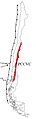
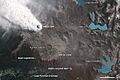
Location of Puyehue-Cordón Caulle (PCCVC) in Chile
-
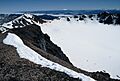
View from Puyehue's summit into its crater
-
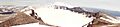
Panorama of Puyehue's crater from near the summit. In the background, black lavas from the 1960 Cordón Caulle eruption.
-
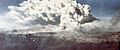
Eruption of Cordón Caulle following the 1960 Valdivia earthquake
-
2011 eruption of Puyehue-Cordón Caulle
- Geology of Valdivia
- List of volcanoes in Chile
See also
 In Spanish: Volcán Puyehue para niños
