
Recreational walks in Derbyshire facts for kids
Derbyshire is a beautiful county in England, famous for its stunning countryside and rolling hills. If you love exploring nature, you'll be happy to know there are over 3,000 miles (4,800 km) of public paths here! These paths are called 'public rights of way,' which means anyone can use them to walk, cycle, or even ride a horse.
This article lists some of the best long-distance walks in Derbyshire. Some of these trails stay completely within Derbyshire, while others cross into nearby counties. They are all great ways to see the amazing landscapes, from quiet valleys to high peaks.
Contents
- Popular Walking Trails in Derbyshire
- Dane Valley Way
- Derwent Valley Heritage Way
- Five Pits Trail
- Goyt Way
- High Peak Trail
- Limestone Way
- Longdendale Trail
- Midshires Way
- Monsal Trail
- Peak District Boundary Walk
- Pennine Bridleway
- Pennine Cycleway
- Pennine Way
- Sabrina Way
- Sett Valley Trail
- Tissington Trail
- Trans Pennine Trail
- White Peak Loop Trail
- Images for kids
Popular Walking Trails in Derbyshire
Many different trails crisscross Derbyshire, offering adventures for everyone. Some of these paths follow old railway lines, which are usually flat and easy to walk or cycle on. Others wind through valleys, alongside rivers, or climb up hills, giving you fantastic views.
Dane Valley Way
The Dane Valley Way is a 48-mile (77 km) path that connects Buxton in Derbyshire to Northwich in Cheshire. Part of this trail follows the lovely River Dane. The section in Derbyshire goes from Buxton to a special spot called Three Shire Heads, where three counties meet.
Derwent Valley Heritage Way
This 55-mile (89 km) trail follows the River Derwent from Ladybower Reservoir near Bamford all the way to the River Trent at Shardlow. As you walk, you'll pass through the Derwent Valley Mills World Heritage Site, which is a very important historical area, and also through the city of Derby.
Five Pits Trail
The Five Pits Trail is a shorter, 5.5-mile (8.9 km) path. It runs from Grassmoor to Tibshelf. This trail is special because it follows an old railway line, making it a fairly flat and easy route for walking or cycling.
Goyt Way
The Goyt Way is a 10-mile (16 km) trail that starts in Whaley Bridge and goes into Greater Manchester, ending at Etherow Country Park. This path is also part of a longer route called the Midshires Way.
High Peak Trail
Another trail built on an old railway line is the High Peak Trail. It's 27 km (17 miles) long and stretches from Buxton to Cromford. This trail offers great views and is popular with walkers and cyclists.
Limestone Way
The Limestone Way is a 50-mile (80 km) path that starts in Castleton and goes to Rocester in Staffordshire. The Derbyshire part of the trail takes you from Castleton to the beautiful River Dove near Thorpe.
Longdendale Trail
The Longdendale Trail is 10 km (6.2 miles) long and follows an old railway line. It runs from Hadfield to the Woodhead Tunnel. This trail is part of the Trans Pennine Trail.
Midshires Way
The Midshires Way is a very long trail, stretching 230 miles (370 km) from Bledlow in Buckinghamshire to Stockport in Greater Manchester. The Derbyshire section starts near Long Eaton at Sawley, then goes through Buxton and the scenic Goyt Valley towards Stockport.
Monsal Trail
The Monsal Trail is another popular path on an old railway line. It's 13.7 km (8.5 miles) long and runs from Wye Dale near Buxton to Coombs viaduct near Bakewell. You'll go through old railway tunnels and over impressive viaducts on this trail.
Peak District Boundary Walk
This is a circular walk around the edge of the Peak District National Park, starting and ending in Buxton. It's a long one, at 190 miles (310 km)! The parts of this walk that are in Derbyshire include sections between:
- Whaley Bridge and Buxton
- Buxton and Tintwistle (near Glossop)
- Owler Bar (near Grindleford) and Thorpe (near Ashbourne)
Pennine Bridleway
The Pennine Bridleway is a special National Trail that's 130 miles (209 km) long. It goes from Middleton-by-Wirksworth to Hebden Bridge. The Derbyshire part of this trail runs between Middleton-by-Wirksworth and Tintwistle (near Glossop). It's designed for horse riders, cyclists, and walkers.
Pennine Cycleway
The Pennine Cycleway is a long-distance cycling route, sponsored by Sustrans. It's 335 miles (539 km) long, starting in Derby and going all the way up to Berwick-upon-Tweed. The Derbyshire section goes from Derby up along the Woodhead Pass valley towards Holmfirth.
Pennine Way
The Pennine Way is a very famous National Trail, stretching 268 miles (431 km) from Edale in Derbyshire to Kirk Yetholm in Scotland. The Derbyshire part of this challenging trail goes from Edale to a place called Black Hill.
Sabrina Way
The Sabrina Way is a long trail, 203 miles (327 km) long, that goes from Hartington to Great Barrington in Gloucestershire. Only a short part of this trail is in Derbyshire, between Hartington and the River Dove.
Sett Valley Trail
The Sett Valley Trail is a short, 3.6 km (2.2 miles) path that follows an old railway line. It connects Hayfield to New Mills. It's a lovely, easy walk through the valley.
Tissington Trail
Another trail on a former railway line is the Tissington Trail. It's 21 km (13 miles) long and runs from Buxton to Parsley Hay. This trail is very popular for walking, cycling, and even horse riding.
Trans Pennine Trail
The Trans Pennine Trail is a huge route, 207 miles (333 km) long, that crosses England from Southport on the west coast to Hornsea on the east coast. The Derbyshire section goes from the border with Greater Manchester at Broadbottom Bridge to the edge of Barnsley. Part of it joins up with the Longdendale Trail. There's also a branch that goes from Chesterfield past Killamarsh towards Sheffield.
White Peak Loop Trail
The White Peak Loop Trail is a circular route, 97 km (60 miles) long, that connects Buxton, Bakewell, and Matlock. This trail uses parts of the High Peak Trail and the Monsal Trail. Some sections were still being completed as of 2020.
Images for kids
-
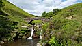
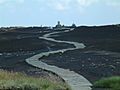
The Dane Valley Way at Three Shires Head.
-
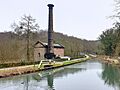
Leawood Pump House and Cromford Canal Aqueduct along the Derwent Valley Heritage Way.
-
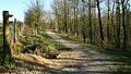
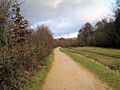
A path along the Five Pits Trail.
-
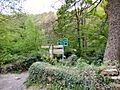
A path junction on the Goyt Way.
-
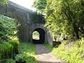
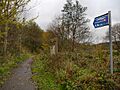
The High Peak Trail, an old railway line.
-
A view along the Limestone Way.
-
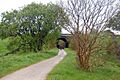
The Longdendale Trail, part of the Trans Pennine Trail.
-
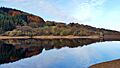
Fernilee Reservoir in the Goyt Valley, along the Midshires Way.
-
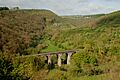
The impressive Headstone Viaduct on the Monsal Trail.
-
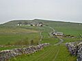
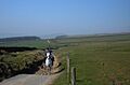
A section of the Peak District Boundary Walk at Dam Dale.
-
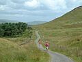
The Pennine Bridleway near Rushop.
-
A road used by the Pennine Cycleway between Buxton and Whaley Bridge.
-
Black Hill, a point on the Pennine Way in the Peak District.
-
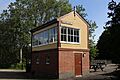
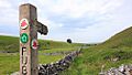
Hartington Signalbox, near the Sabrina Way.
-
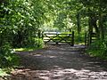
A gate at the end of the Sett Valley Trail.
-
The Tissington Trail near Tissington.
-
The Trans Pennine Trail heading towards Broadbottom.
-
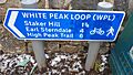
A sign for the White Peak Loop at Harpur Hill.


.jpg)


.jpg)


.jpg)

