
Ridge Route facts for kids
Quick facts for kids Ridge Route |
|
|---|---|
|
Ridge Route highlighted in red
|
|
| Route information | |
| Length | 44 mi (71 km) |
| Existed | 1915–1970 |
| Component highways |
|
| Major junctions | |
| South end | |
| North end | |
| Location | |
| Counties: | Los Angeles, Kern |
| Highway system | |
| State highways in California(list • pre-1964) History • Unconstructed • Deleted • Freeway • Scenic |
|
|
Ridge Route, Old
|
|
| Lua error in Module:Location_map at line 420: attempt to index field 'wikibase' (a nil value). | |
| Nearest city | Castaic, California |
| Built | 1915 |
| Architect | W. Lewis Clark and J.B. Woodson |
| NRHP reference No. | 97001113 |
| Added to NRHP | September 25, 1997 |
.jpg)
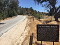
The Ridge Route was a famous two-lane highway in California. It connected Los Angeles County and Kern County. The road opened in 1915. It was the first paved highway to directly link the Los Angeles Basin with the southern Central Valley. It crossed the Tejon Pass and the rugged Sierra Pelona Mountains.
Much of the old road goes through the Angeles National Forest. It passes many historic spots. These include the National Forest Inn and Sandberg's Summit Hotel. The Ridge Route was later replaced by newer, wider highways. These include U.S. Route 99 and later Interstate 5. In 1997, a part of the road in the Angeles National Forest was added to the National Register of Historic Places. Today, some parts of the old road are closed. Other parts are used by local cars.
Contents
Exploring the Old Ridge Route
The Ridge Route was officially called the Castaic–Tejon Route. It stretched from SR 126 at Castaic Junction to Grapevine. Today, much of the original road near Castaic is covered by Interstate 5.
As you travel north from Castaic, the old road begins to climb. A section of the road, known as the Five-Mile Grade, was straightened in 1924. It now runs next to the southbound lanes of I-5. The Ridge Route enters the Angeles National Forest about 1 mile (1.6 km) south of Templin Highway. Here, it is known as Forest Service road 8N04.
Historic Stops Along the Way
Several important places were located along the Ridge Route in the forest. These spots offered food, lodging, and gas for travelers.
National Forest Inn: A Popular Stop
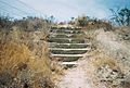
The National Forest Inn was a popular place to stop. It was on the west side of the road. This inn had white buildings and was a busy spot for travelers. In 1932, a fire destroyed the inn. When the new highway bypassed this area, the inn was not rebuilt. Today, only the concrete steps remain.
Swede's Cut: A Big Dig
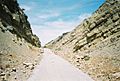
About 2 miles (3.2 km) north of the National Forest Inn is Serpentine Drive. Here, the road curves around hills as it climbs. Further north, the road goes through Swede's Cut. This was also called Big Cut. It was the largest cut on the route, dug 110 feet (34 m) deep into the earth.
Reservoir Summit: High Point for Travelers
Reservoir Summit is 3,883 feet (1,184 m) above sea level. The Reservoir Summit Café was a fancy restaurant here. It closed in the late 1920s. Only its foundation remains today. The summit was named after a reservoir that is now dry.
Kelly's Half Way Inn: A Convenient Stop
Kelly's Half Way Inn was roughly halfway between Los Angeles and Bakersfield. It sat on a small hill with one tree. Today, only parts of its foundation are left.
Tumble Inn: Another Roadside Lodge
The Tumble Inn was on the west side of the road. It was later called Mountain View Lodge. This inn closed when the Ridge Route Alternate opened in 1933. You can still see steps and a retaining wall. One step even has "TUMBLE INN" written in the concrete!
Sandberg's Summit Hotel: A Log Cabin Retreat
The Sandberg's Summit Hotel was just north of Liebre Summit. This was the highest point on the road, at 4,233 feet (1,290 m). The hotel was built in 1914 and opened with the road in 1915. It was a high-class hotel made of logs. The hotel burned down in 1961. Only parts of its foundation and a rock wall remain. The name "Sandberg" is still used for a weather station nearby.
The Final Stretch to Grapevine
The Ridge Route crosses the West Branch California Aqueduct with SR 138. It then splits off onto Gorman Post Road. It rejoins the path of I-5 at Gorman. From Gorman to Grapevine, much of the old road is now covered by the newer highways.
The path of the Ridge Route is now called Peace Valley Road and Lebec Road. It passes over Tejon Pass and by Lebec and Fort Tejon. After Fort Tejon, the route goes down through Grapevine Canyon to Grapevine.
Deadman's Curve: A Famous Bend
One of the most famous curves on the road was Deadman's Curve. It was also called Death Curve. You can still see it from Digier Road. The original plan for the road in this area was changed. A flood in 1914 destroyed the first work. So, the road was built higher up the canyon.
At Grapevine, the land becomes flat. The road north of Grapevine was once the longest straight section in California. It was about 17 miles (27 km) long in 1926. Most of this road is now under I-5 and SR 99.
History of the Ridge Route
Before the Ridge Route, traveling between Los Angeles and the San Joaquin Valley was harder. Roads were longer and less direct.
Early Roads and Trails
El Camino Real was one of the first major roads in California. It connected Los Angeles with missions and settlements to the north. Another route, El Camino Viejo, went through the San Joaquin Valley.
The Butterfield Overland Mail was the first mail service to California. From 1858 to 1861, it used a route similar to El Camino Viejo. To make sure the mail stages passed through Los Angeles, the county spent money to deepen a cut at San Fernando Pass. This cut later became known as Beale's Cut.
The Southern Pacific Railroad also built a line to San Francisco. It included the 6,966-foot (2,123 m) San Fernando Tunnel. This railroad route was even longer than the stagecoach routes.
In the 1910s, power companies built lines through the area. The General Pipe Line Company built an oil pipeline in 1913. The Midway Gas Company and Pacific Light and Power Company also built lines. These lines often followed paths similar to the future Ridge Route.
By the early 1900s, the main car routes between Los Angeles and the San Joaquin Valley were the Tejon Pass Route and the Tehachapi Route. In 1895, the State Bureau of Highways suggested building a more direct road. A plan to build a state highway system was approved in 1909 and 1910. The new California Highway Commission began building the Ridge Route.
Building the Ridge Route
The California Highway Commission looked at several routes. They chose a direct path from Saugus to Gorman. This route went over the top of a ridge for many miles. To save money and avoid changing the land too much, the road was built with 697 curves. It wound high in the mountains.
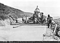
Construction on the Ridge Route began in 1914. It was one of the first projects by the California Highway Commission. Workers used horse-drawn scrapers to build the road. The new road was designed with a gentle slope of 6 percent. It cut the travel distance by 24 miles (39 km) compared to the Tejon Pass Route. It saved 58 miles (93 km) compared to the Midway Route.
The speed limit on the Ridge Route was 15 miles per hour (24 km/h). This meant a trip from Los Angeles to Bakersfield took about 12 hours. The curves on the Ridge Route added up to about 109.5 full circles! The unpaved road cost $450,000 and opened in October 1915.
The San Francisco Chronicle called the new route "one of the most remarkable engineering feats." It was also said to help keep California united. It linked the northern and southern parts of the state over the tough mountains.
Work to pave the Ridge Route with 4-inch (100 mm) thick reinforced concrete began in 1917. It was delayed by World War I. The road reopened on November 15, 1919. Most of it was paved, except for the section north of Lebec. This part was paved from 1919 to 1921. The paving added about $1 million to the cost. The total price was about $1.5 million.
Newer Roads and the Old Ridge Route's Future

In 1929, the state decided to build a new bypass. This was called the Ridge Route Alternate. It shortened the route by 9.6 miles (15.4 km). It also made the curves much wider and safer. This was done because the old road had many accidents. It also needed to handle more cars.
Construction on the Ridge Route Alternate began in 1930. The southern part opened in 1933. The replacement for the Grapevine grade was finished in 1936. This new three-lane road cost $3.5 million. It was paid for by a state gas tax. It was expected to save so much time and gas that it would pay for itself in 2.5 years.
Even this four-lane Ridge Route Alternate became too small for the traffic. So, the first section of the eight-lane freeway I-5 opened in 1960. Large parts of the Ridge Route Alternate were used for the new I-5. However, the area through the present Pyramid Lake was completely bypassed. I-5 over the mountains was finished on August 24, 1970. It cost $103 million.

Parts of the old road still exist as a county road. The longest preserved part is between Castaic and SR 138 near Sandberg. This includes the section through the Angeles National Forest.
Harrison Scott, a retired engineer, helped get the road added to the National Register of Historic Places. He worked for six years to make this happen. On September 25, 1997, the National Park Service added 17.6 miles (28.3 km) of the road in the forest to the National Register. The Ridge Route was also named a California Historic Civil Engineering Landmark in 2008.

The route was repaired in 2005 after heavy rain. However, as of early 2013, the road was not reopened. This was due to concerns from Angeles National Forest officials.
Major Intersections
| County | Location | mi | km | Destinations | Notes |
|---|---|---|---|---|---|
| Los Angeles | Castaic Junction | 0 | 0.0 | The road continued south from here. | |
| 0 | 0.0 | ||||
| Gorman | 30 | 48 | |||
| Kern | | 34 | 55 | Frazier Park | |
| Grapevine | 44 | 71 | The road continued north from here. | ||
| 1.000 mi = 1.609 km; 1.000 km = 0.621 mi | |||||
Images for kids
-
Remains of the steps to the National Forest Inn.
-
A historical marker for the Ridge Route.
-
Looking north through Swede's Cut.
-
Workers leveling concrete pavement on the original Ridge Route in 1915.
-
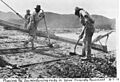
Workers reinforcing concrete on the Ridge Route in 1919.


