Rift facts for kids
In geology, a rift is a long, narrow crack in the Earth's outer layer, called the lithosphere. Imagine the Earth's crust being slowly pulled apart. This pulling motion is a type of extensional tectonics.
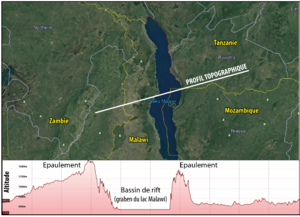
A typical rift often has a central sunken area. This area is created by faults (cracks in the Earth's crust) where one side drops down. This sunken area is called a graben, or more often, a half-graben. The sides of the rift, known as rift flanks, can sometimes be pushed upwards.
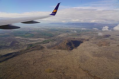
When rifts are above sea level, they form a rift valley. These valleys can sometimes fill with water, creating rift lakes. You might also find volcanic rocks along the center of a rift, and active volcanism (volcanoes erupting) happens in many rift systems.
Huge rifts are found along the middle of most mid-ocean ridges. This is where new oceanic crust is made as two tectonic plates move away from each other at a divergent boundary.
Sometimes, a rift starts to form on a continent but then stops before the continent fully breaks apart. These are called failed rifts. They often happen at a triple junction, which is where three rifts meet, usually over a very hot spot deep inside the Earth called a hotspot. Usually, two of these rifts keep going and form new oceans, while the third one stops and becomes a feature called an aulacogen.
Contents
How Do Rifts Look?
Most rifts are made up of several smaller sections that connect to form one long zone. Each section of a rift usually looks like a half-graben, meaning it's controlled by a single main normal fault (a type of fault where the hanging wall moves down relative to the footwall).
The length of these sections can change depending on how thick and strong the Earth's lithosphere is in that area. For example, in places with thick, cold lithosphere, like the Baikal Rift, sections can be longer than 80 kilometers (about 50 miles). But in warmer, thinner areas, sections might be shorter than 30 kilometers (about 18 miles).
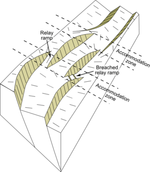
Along the center of a rift, the main fault that forms the basin can change its position or even its direction of dip (which way it slopes). The places where these sections meet are often more complex and cross the rift at a sharp angle. These areas are called accommodation zones because they help manage the different amounts of movement between the rift sections.
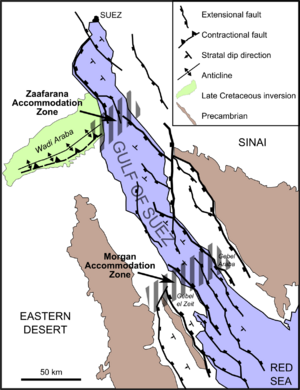
Accommodation zones can be simple, like a ramp where two faults overlap, or very complex, especially when the sections have opposite dip directions. Sometimes, old cracks or structures in the Earth's crust can influence where these accommodation zones form. For example, in the Gulf of Suez rift, an accommodation zone is found where an old shear zone (a zone of intense deformation) meets the rift.
The areas around rifts that are pushed up are called rift flanks or shoulders. These elevated areas are usually about 70 kilometers (about 43 miles) wide. It was once thought that large elevated areas like the Brazilian Highlands or the Scandinavian Mountains were rift shoulders, but scientists now know they are not.
How Rifts Develop
Starting a Rift
When a rift first begins, the upper part of the Earth's lithosphere starts to stretch. This stretching creates many small, unconnected normal faults, which leads to the formation of separate, isolated basins. In rifts that are above water, rivers and streams at the beginning of rifting usually flow inwards, not all the way through the rift.
Growing a Rift
As a rift continues to develop, some of the individual fault sections grow bigger. They eventually connect to form larger, main faults that control the rift. More stretching then happens along these bigger faults. The longer faults and wider spacing between them create more continuous areas where the ground sinks along the rift's center.
At this stage, the rift shoulders (the land on either side of the rift) can be pushed up significantly. This uplift strongly affects how water flows and where sediments (like sand and mud) are deposited in the rift basins.
During the most intense period of rifting, as the Earth's crust gets thinner, the surface of the Earth sinks. At the same time, the Moho (the boundary between the crust and the mantle) becomes higher. The mantle lithosphere (the solid part of the mantle attached to the crust) also thins, causing the hot asthenosphere (the soft, flowing part of the mantle) to rise closer to the surface. This brings a lot of heat into the thinning lithosphere, which can cause rocks to melt and form new rocks. This process can lead to a type of mountain building in areas where the crust is stretching, which is called rifting orogeny.
After the Rift Stops
Once the stretching stops, the mantle beneath the rift cools down. This cooling causes a wide area of the land to sink even more, which is called post-rift subsidence. The amount of sinking depends on how much the crust thinned during the rifting phase. It's also affected by how much the rift basin fills with sediments, because sediments are heavier than water.
A simple model called the 'McKenzie model' helps estimate how much the crust thinned based on how much the land sinks after rifting. A more advanced model, the 'flexural cantilever model', also considers the shape of the rift faults and how the upper crust bends and balances itself (called flexural isostasy).
Rifts with Many Phases
Some rifts have a very long and complicated history, with several different periods of stretching. For example, the North Sea rift shows signs of several separate rifting phases that happened over more than 100 million years, from the Permian period to the earliest Cretaceous period.
From Rift to Ocean
Rifting can eventually lead to continents breaking apart and new ocean basins forming. If rifting is successful, it leads to seafloor spreading along a mid-oceanic ridge. This creates two new continental margins (the edges of the continents) that are mirror images of each other, separated by a new ocean.
Rifting can be 'active', meaning it's driven by hot material rising from deep within the Earth (like mantle convection). Or it can be 'passive', meaning it's caused by large-scale forces from far away that pull the lithosphere apart.
As a rift develops, the way the land deforms and how magma (molten rock) moves interact. This can create two types of rifted margins:
- Magma-rich margins: These have a lot of volcanic features. Most passive continental margins around the world are magma-rich.
- Magma-poor margins: These are affected by large faults and extreme stretching of the crust. Because of this, rocks from the upper mantle, like peridotites and gabbros, are often exposed and changed by water (serpentinized) along faults on the seafloor.
Magma and Rifts
Many rifts have at least a little bit of magmatic activity (molten rock moving and erupting), especially when they first start to form. Common types of volcanic rocks found in rifts include Alkali basalts and rocks from bimodal volcanism (meaning both basaltic and rhyolitic rocks are present).
Recent studies suggest that certain types of granites found in mountain ranges that formed from collisions are actually products of rifting magma that occurred after the collision.
Why Rifts Are Important
The sedimentary rocks (rocks formed from layers of sediment) found in continental rifts are very important because they contain valuable deposits of both minerals and hydrocarbons (like oil and natural gas).
Mineral Deposits
Certain mineral deposits, called SedEx deposits, are mostly found in continental rift areas. They form in the layers of rock that build up after the main rifting stops. This happens when hot, mineral-rich fluids, often linked to magma activity, are released onto the seabed.
Oil and Gas
Continental rifts are major locations for finding oil and natural gas. Famous examples include the Viking Graben and the Gulf of Suez Rift. About 30% of the world's largest oil and gas fields are found in these rift settings. In 1999, it was estimated that rifts held about 200 billion barrels of recoverable oil.
Source rocks (rocks that contain organic material that can turn into oil or gas) often form within the sediments that fill the active rift (called syn-rift sediments). These can form in a lake environment (wikt:lacustrine) or in a restricted marine environment. However, not all rifts have these types of source rocks.
Reservoir rocks (rocks that can hold oil and gas) can be found in rocks that formed before, during, or after the rifting. Good regional seals (layers of rock that prevent oil and gas from escaping) can be present in the post-rift sediments if mudstones or evaporites (rocks formed from evaporated water) are deposited.
Just over half of the estimated oil reserves in rifts are found in those with marine syn-rift and post-rift sediments. Just under a quarter are in rifts with non-marine syn-rift and post-rift sediments. About an eighth are in rifts with non-marine syn-rift sediments but marine post-rift sediments.
Examples of Rifts
Here are some well-known rifts around the world:
- The Asunción Rift in Eastern Paraguay
- The Canadian Arctic Rift System in northern North America
- The East African Rift, a very active rift system
- The West and Central African Rift System
- The Red Sea Rift
- The Gulf of California
- The Baikal Rift Zone, where Lake Baikal is the deepest continental rift on Earth.
- The Gulf of Suez Rift
- Throughout the Basin and Range Province in North America
- The Rio Grande Rift in the southwestern US
- The rift zone that contains the Gulf of Corinth in Greece
- The Reelfoot Rift, an old, buried failed rift under the New Madrid Seismic Zone in the Mississippi embayment
- The Rhine Rift, in southwestern Germany, also known as the Upper Rhine valley, which is part of the European Cenozoic Rift System
- The Taupō Volcanic Zone in the northeast North Island of New Zealand
- The Oslo Graben in Norway
- The Ottawa-Bonnechere Graben in Ontario and Quebec, Canada
- The Northern Cordilleran Volcanic Province in British Columbia, Yukon and Alaska
- The West Antarctic Rift System in Antarctica
- The Midcontinent Rift System, an ancient rift in central North America
- The Midland Valley in Scotland
- The Fundy Basin, a Triassic rift basin in southeastern Canada
- The Cambay, Kachchh, and Narmada rifts in northwestern Deccan volcanic province of India
See also
 In Spanish: Rift para niños
- Rift zone
- Wilson Cycle


