
San Ramon, California facts for kids
Quick facts for kids
San Ramon, California
|
|||
|---|---|---|---|

San Ramon Waterfall Park
|
|||
|
|||

Location in Contra Costa County and the state of California
|
|||

San Ramon, California
Location in the United States
|
|||
| Country | United States | ||
| State | California | ||
| County | Contra Costa | ||
| Incorporated | July 1, 1983 | ||
| Area | |||
| • Total | 18.72 sq mi (48.48 km2) | ||
| • Land | 18.68 sq mi (48.39 km2) | ||
| • Water | 0.03 sq mi (0.09 km2) 0.09% | ||
| Elevation | 486 ft (148 m) | ||
| Population
(2020)
|
|||
| • Total | 84,605 | ||
| • Rank | 96th in California | ||
| • Density | 4,519.5/sq mi (1,745.15/km2) | ||
| Time zone | UTC−8 (Pacific) | ||
| • Summer (DST) | UTC−7 (PDT) | ||
| ZIP Codes |
94582–94583
|
||
| Area code | 925 | ||
| FIPS code | 06-68378 | ||
| GNIS feature IDs | 1656275, 2411805 | ||


San Ramon (Spanish: San Ramón, meaning "Saint Raymond") is a city in Contra Costa County, California. It is located in the San Ramon Valley, about 34 miles east of San Francisco. In 2020, San Ramon had a population of 84,605 people. This makes it the fourth largest city in Contra Costa County.
San Ramon is home to the main offices of big companies like Chevron Corporation and The Cooper Companies. It also has the West Coast offices for AT&T and GE Digital. The city hosts fun yearly events like the Art and Wind Festival in May and the Run for Education in October.
Contents
History of San Ramon
The land where San Ramon is now was once home to the Seunen people. They were an Ohlone/Costanoan group who lived near creeks. Around 1797, their land became grazing areas for Mission San José. In 1834, the land was given to José María Amador as part of the Rancho San Ramon land grant.
Amador named the area "San Ramón" after a Native American vaquero (cowboy) who took care of the mission's sheep there. He added "San" as was common in Spanish. In 1850, the first American settlers, Leo and Mary Jane Norris, bought part of Amador's land.
A railroad line, the San Ramon Branch Line, was built in 1891. It connected San Ramon to other areas. Passenger train service stopped in 1934. Later, in 1986, the old railroad path became the Iron Horse Regional Trail, which is now a popular trail for walking and biking. In 2001, San Ramon was named a Tree City USA.
Geography and Nature

Mount Diablo is a large mountain visible from most parts of San Ramon. The Las Trampas Regional Wilderness is a natural area bordering the city to the northwest. The smaller Bishop Ranch Regional Preserve is on San Ramon's western side.
San Ramon has both rolling hills from the Diablo Range and flatter areas in the San Ramon Valley. Most of the city is developed with homes and buildings. However, areas around the city still have open grasslands and oak tree orchards. The grasses are golden in dry months and turn green when it rains.
San Ramon's Climate
San Ramon has a Mediterranean climate. This means it has warm to hot, dry summers. Winters are mild or cool, wet, and short. The weather is similar to nearby cities like Danville and Pleasanton. Sometimes, fog rolls in from the San Francisco Bay, but it usually clears up by late morning.
| Climate data for San Ramon, California | |||||||||||||
|---|---|---|---|---|---|---|---|---|---|---|---|---|---|
| Month | Jan | Feb | Mar | Apr | May | Jun | Jul | Aug | Sep | Oct | Nov | Dec | Year |
| Record high °F (°C) | 73 (23) |
80 (27) |
83 (28) |
97 (36) |
99 (37) |
105 (41) |
102 (39) |
107 (42) |
111 (44) |
98 (37) |
87 (31) |
76 (24) |
108 (42) |
| Mean daily maximum °F (°C) | 58 (14) |
61 (16) |
63 (17) |
67 (19) |
70 (21) |
75 (24) |
80 (27) |
82 (28) |
77 (25) |
73 (23) |
65 (18) |
59 (15) |
68 (20) |
| Mean daily minimum °F (°C) | 39 (4) |
43 (6) |
44 (7) |
46 (8) |
49 (9) |
52 (11) |
54 (12) |
55 (13) |
55 (13) |
52 (11) |
45 (7) |
41 (5) |
48 (9) |
| Record low °F (°C) | 26 (−3) |
26 (−3) |
29 (−2) |
30 (−1) |
35 (2) |
41 (5) |
44 (7) |
43 (6) |
41 (5) |
32 (0) |
30 (−1) |
18 (−8) |
18 (−8) |
| Average precipitation inches (mm) | 5.20 (132) |
4.80 (122) |
4.27 (108) |
1.72 (44) |
0.71 (18) |
0.15 (3.8) |
0.06 (1.5) |
0.11 (2.8) |
0.36 (9.1) |
1.55 (39) |
3.69 (94) |
3.84 (98) |
26.46 (672) |
| Source 1: The Weather Channel | |||||||||||||
| Source 2: MSN Weather | |||||||||||||
People of San Ramon
| Historical population | |||
|---|---|---|---|
| Census | Pop. | %± | |
| 1880 | 75 | — | |
| 1970 | 4,084 | — | |
| 1980 | 22,356 | 447.4% | |
| 1990 | 35,303 | 57.9% | |
| 2000 | 44,722 | 26.7% | |
| 2010 | 72,148 | 61.3% | |
| 2020 | 84,605 | 17.3% | |
| U.S. Decennial Census | |||
San Ramon has grown a lot over the years. In 1880, only 75 people lived here. By 2020, the population had grown to 84,605.
Population in 2020
The 2020 Census showed that San Ramon is a diverse city.
| Race / Ethnicity (NH = Non-Hispanic) | Pop 2000 | Pop 2010 | Pop 2020 | % 2000 | % 2010 | % 2020 |
|---|---|---|---|---|---|---|
| White alone (NH) | 32,356 | 34,956 | 27,140 | 72.35% | 48.45% | 32.08% |
| Black or African American alone (NH) | 842 | 1,946 | 2,113 | 1.88% | 2.70% | 2.50% |
| Native American or Alaska Native alone (NH) | 142 | 128 | 100 | 0.32% | 0.18% | 0.12% |
| Asian alone (NH) | 6,629 | 25,531 | 43,052 | 14.82% | 35.39% | 50.89% |
| Pacific Islander alone (NH) | 89 | 141 | 174 | 0.20% | 0.20% | 0.21% |
| Some Other Race alone (NH) | 131 | 146 | 427 | 0.29% | 0.20% | 0.50% |
| Mixed Race or Multi-Racial (NH) | 1,295 | 3,050 | 4,497 | 2.90% | 4.23% | 5.32% |
| Hispanic or Latino (any race) | 3,238 | 6,250 | 7,102 | 7.24% | 8.66% | 8.39% |
| Total | 44,722 | 72,148 | 84,605 | 100.00% | 100.00% | 100.00% |
Economy and Jobs


San Ramon's economy is strong, thanks to places like Bishop Ranch. This is a large business park with many offices and some shops. It helps the city by providing a good tax base. Bishop Ranch was built on land that used to be farmland.
Many big companies have offices here. These include the main office of Chevron Corporation and the West Coast office of AT&T Inc.. United Parcel Service (UPS) has a shipping center, and Toyota has a regional office. GE Global Research also has a software center in Bishop Ranch. In 2016, self-driving shuttles started running in Bishop Ranch, a first for North America!
Top Employers in San Ramon
Here are some of the biggest employers in San Ramon:
| # | Employer | # of Employees |
|---|---|---|
| 1 | Chevron | 4,000 |
| 2 | Pacific Gas & Electric | 2,346 |
| 3 | Bank of the West | 1,600 |
| 4 | Robert Half International | 1,285 |
| 5 | Accenture | 750 |
| 6 | San Ramon Regional Medical Center | 650 |
| 7 | Primed Management Consulting | 453 |
| 8 | United Parcel Service | 315 |
| 9 | GE Digital | 284 |
| 10 | Pacific Bell Telephone | 265 |
Downtown San Ramon
In 2014, the city approved plans for a new downtown area called City Center. It has many shops, including furniture and clothing stores, and a movie theater. The famous architect Renzo Piano helped design it. City Center officially opened on November 8, 2018.
Arts and Culture

San Ramon has several libraries for reading and learning. These include the San Ramon Library and Dougherty Station Library.
Forest Home Farms in San Ramon is a special place. It is listed on the National Register of Historic Places, meaning it's an important historical site.
Parks and Recreation
San Ramon has 58 parks and an 18-hole golf course called the San Ramon Golf Club.
Memorial Park

This park is on a hill overlooking Bollinger Canyon Road. It was renamed Memorial Park to honor Tom Burnett, a San Ramon resident, and others who died in the September 11 attacks of 2001. A plaque and a flagpole are dedicated to them.
This 16-acre park has many features. It includes a play area, a BMX course, and picnic spots. There are also bocce ball and horseshoe courts, a ball field, and a dog park. The play area has two big structures, one for younger kids (2–5) and one for older kids (5–12).
Education in San Ramon
San Ramon's public schools are part of the San Ramon Valley Unified School District (SRVUSD). This district serves about 31,000 students. The city has 12 elementary schools and four middle schools.
The two main high schools are California High School and Dougherty Valley High School. Dougherty Valley High School is highly ranked in California and nationally. Some middle schools include Pine Valley, Gale Ranch, Windemere Ranch, and Iron Horse. Elementary schools include Walt Disney, Neil Armstrong, and Coyote Creek.
Higher Education Options
For students looking to continue their education, San Ramon has:
- Diablo Valley College – a branch campus
- University of San Francisco – a regional campus
- UC Davis Graduate School of Management – a program for working professionals
Getting Around San Ramon
Buses and Trains
Local bus service in San Ramon is provided by County Connection. The closest train station for Bay Area Rapid Transit (BART) is the West Dublin/Pleasanton station, about 6 miles away.
Roads
The main highway in the area is Interstate 680. There are no US or California state highways that go directly through San Ramon.
Airports
San Ramon is close to Buchanan Field Airport and Livermore Municipal Airport. However, these airports do not have regular commercial flights. The closest major airport with flights to many places is Oakland International Airport. San Francisco International Airport is also nearby and handles most international flights for the Bay Area.
Notable People from San Ramon
Many interesting people have lived in or are from San Ramon:
- Mark Appel, professional baseball pitcher
- David Bingham, professional soccer player
- Tom Burnett, a hero from United Airlines Flight 93 on 9/11
- Austin Hooper, professional football player
- James Jones, professional football player
- Khalil Mack, professional football player
- Auston Matthews, NHL hockey player
- Dennis Richmond, former news anchor
- Tiffany Roberts, U.S. soccer player
- Maggie Steffens, gold medal-winning water polo player
Images for kids
-
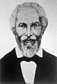
José María Amador, who was granted the land that became Rancho San Ramon in 1834.
.jpg)
See also
 In Spanish: San Ramón (California) para niños
