
Santa Rosa Island (California) facts for kids

Sentinel-2 satellite image
|
|

Santa Rosa Island near the top left
|
|
| Geography | |
| Location | North Pacific Ocean |
| Coordinates | 33°58′N 120°06′W / 33.967°N 120.100°W |
| Area | 83.12 sq mi (215.3 km2) |
| Area rank | 2nd largest of the Channel Islands |
| Highest elevation | 1,589 ft (484.3 m) |
| Highest point | Soledad Peak |
| Administration | |
|
United States
|
|
| State | California |
| County | Santa Barbara |
| National Park | Channel Islands |
| Symbols | |
| Demographics | |
| Population | 2 (2000) |
| Pop. density | 0.024 /sq mi (0.0093 /km2) |
| Additional information | |
| Time zone | |


Santa Rosa Island is a beautiful island off the coast of California. It's the second largest of the Channel Islands of California. The island covers about 53,195 acres (215 square kilometers).
Santa Rosa Island is located about 26 miles (42 kilometers) from Santa Barbara, California. It is part of Channel Islands National Park.
Long ago, the Chumash people, a Native American group, lived on the Channel Islands. They were there when Europeans first arrived.
Scientists found very old human remains on the island in 1959. These remains, called Arlington Springs Man, might be the oldest human remains ever found in North or South America, dating back 13,000 years!
The island is also home to a special tree called the Torrey Pine. This type of pine tree grows in only two places in the entire world.
Contents
Island Geography and Landscape
The island has rolling hills, deep canyons, and a lagoon along its coast. The highest point on the island is Vail Peak, which is 1,589 feet (484 meters) tall.
During the last ice age, the four northern Channel Islands were connected. They formed one large island called Santa Rosae. This super-island was only about five miles (8 kilometers) from the mainland coast.
A Look at Santa Rosa Island's History
Early Island Life and People
The ancestors of the Chumash Indians lived on Santa Rosa Island for thousands of years. They built many villages along the coast and inland. Research shows that people lived on the island at least 12,000 years ago. These early people were skilled at living by the sea.
The Chumash people had a special name for the driftwood that washed ashore. They called it wimal. They used these logs to build their famous tomols, which were plank canoes.
In the late 1700s, European explorers visited the island. Juan Rodriguez Cabrillo's crew explored the island after he died. They found three Chumash villages with about 40-50 people. The Chumash called their island Wima. Later, George Vancouver named it Santa Rosa on his map in 1792.
By the late 1820s, many Chumash people were moved to Mission Santa Barbara and Mission San Buenaventura. This happened after Franciscan missionaries baptized many of them in 1822.
Island Ownership and Ranching
In the 1830s and 1840s, George Nidever hunted sea otters on the island. He did this to get their valuable fur.
In 1843, the Mexican government gave Santa Rosa Island as a land grant to brothers José Antonio Carrillo and Carlos Antonio Carrillo. They then gave the island to Carlos's daughters. Their husbands, John Coffin Jones and Alpheus Basil Thompson, worked together to manage the island.
In 1852, the Channel Islands became part of the United States. This happened after the Mexican–American War ended with the Treaty of Guadalupe Hidalgo. The island's ownership was officially confirmed in 1871.
Later, by 1870, the More brothers bought the island. They turned it into a huge sheep ranch. Their main base was at Bechers Bay.
In 1902, the More family sold the island to Walter L. Vail and John V. Vickers. The Vail and Vickers Company changed the sheep ranch into a cattle ranch. They raised cattle there.
Military Presence and Oil Exploration
During WW II (World War II), the United States Army leased part of the island. They built a radar post there from 1943 to 1945. About 75 men worked at this site.
In 1952, during the Cold War, the United States Air Force built an early-warning radar site. This site could hold 200 men. At the same time, the United States Navy built a communication station. This station helped track missiles launched from Point Mugu NAS. The Air Force stopped using its lease in 1963.
Several oil companies tried to find oil on the island. Standard Oil Company in 1932, Richfield Oil Company in 1938, and Superior Oil Company in 1947 all drilled but found no oil. In 1971, Mobil Oil Corporation also tried, drilling six wells, but they were all unsuccessful.
Becoming a National Park
In 1980, Santa Rosa Island became part of Channel Islands National Park. The previous owners, Vail & Vickers, were not happy about this. They worked to make sure the government would buy their land first.
Vail & Vickers sold the island in 1986 for almost $30 million. After that, the National Park Service allowed them to continue some activities for a while. By 1998, almost all ranching and hunting had stopped. Vail's agreement to use the island ended in December 2011.
There was a discussion in 2006 about allowing disabled veterans to hunt elk on the island. This rule was put into a defense bill but was later removed.
Fun Activities on Santa Rosa Island

Santa Rosa Island offers many fun things to do. You can go kayaking, camping, and hiking.
A private boat company offers trips to the island all year. If you want to camp, you can make reservations through the Channel Islands National Park offices in Ventura, California. There's also a charter flight service from Camarillo Airport for hikers and campers.
CSUCI Research Station
Since 2012, California State University, Channel Islands (CSUCI) has run a research station on Santa Rosa Island. This station helps scientists study the island's nature and history. It also helps teach people about these important resources.
Island Ecology and Climate

Santa Rosa Island is home to a special type of Torrey pine tree. This tree is an endangered species. There are only about 1,000 of these trees left. The island oak tree also grows naturally on the island.
Some animals that once lived here, like flightless geese, giant mice, and pygmy mammoths, are now extinct. But other unique animals still live here. These include the island fox and the spotted skunk.
The island also has special plants, like the munchkin dudleya. This is one of six plant species found only on Santa Rosa Island. Another rare plant, Hoffman's rockcress, has one of its only three known populations here.
The waters around Santa Rosa Island are important for sea life. They are a nursery for many marine animals and seabirds. Large great white sharks are common in the northern Channel Islands. They feed on the many marine mammals. It's important to be careful when swimming or diving near seal colonies.
A rare type of lichen, called Caloplaca obamae, was found on the island in 2007. It was named after former United States President Barack Obama.
Santa Rosa Island has a warm-summer Mediterranean climate. This means it has warm, dry summers and mild, wet winters.
| Climate data for Santa Rosa Island, California, 1991–2020 averages, extremes 1990–present | |||||||||||||
|---|---|---|---|---|---|---|---|---|---|---|---|---|---|
| Month | Jan | Feb | Mar | Apr | May | Jun | Jul | Aug | Sep | Oct | Nov | Dec | Year |
| Record high °F (°C) | 87 (31) |
85 (29) |
89 (32) |
95 (35) |
96 (36) |
100 (38) |
100 (38) |
100 (38) |
109 (43) |
98 (37) |
92 (33) |
86 (30) |
109 (43) |
| Mean maximum °F (°C) | 76.2 (24.6) |
74.6 (23.7) |
75.1 (23.9) |
80.4 (26.9) |
79.5 (26.4) |
80.1 (26.7) |
82.0 (27.8) |
85.7 (29.8) |
91.3 (32.9) |
88.8 (31.6) |
83.0 (28.3) |
75.2 (24.0) |
94.5 (34.7) |
| Mean daily maximum °F (°C) | 59.3 (15.2) |
58.2 (14.6) |
58.5 (14.7) |
58.9 (14.9) |
60.2 (15.7) |
63.2 (17.3) |
67.1 (19.5) |
68.6 (20.3) |
70.8 (21.6) |
69.3 (20.7) |
64.4 (18.0) |
59.1 (15.1) |
63.1 (17.3) |
| Daily mean °F (°C) | 53.6 (12.0) |
52.5 (11.4) |
52.3 (11.3) |
52.4 (11.3) |
53.6 (12.0) |
56.2 (13.4) |
59.8 (15.4) |
61.1 (16.2) |
63.0 (17.2) |
62.0 (16.7) |
57.9 (14.4) |
53.4 (11.9) |
56.5 (13.6) |
| Mean daily minimum °F (°C) | 48.0 (8.9) |
46.9 (8.3) |
46.2 (7.9) |
46.1 (7.8) |
47.3 (8.5) |
49.6 (9.8) |
52.5 (11.4) |
53.6 (12.0) |
55.3 (12.9) |
54.7 (12.6) |
51.4 (10.8) |
47.7 (8.7) |
49.9 (10.0) |
| Mean minimum °F (°C) | 40.4 (4.7) |
40.1 (4.5) |
40.3 (4.6) |
41.0 (5.0) |
43.4 (6.3) |
45.7 (7.6) |
48.5 (9.2) |
49.6 (9.8) |
49.8 (9.9) |
48.3 (9.1) |
44.1 (6.7) |
40.5 (4.7) |
37.6 (3.1) |
| Record low °F (°C) | 34 (1) |
32 (0) |
35 (2) |
34 (1) |
39 (4) |
42 (6) |
45 (7) |
45 (7) |
47 (8) |
43 (6) |
38 (3) |
28 (−2) |
28 (−2) |
| Average precipitation inches (mm) | 1.87 (47) |
2.71 (69) |
1.67 (42) |
0.75 (19) |
0.26 (6.6) |
0.10 (2.5) |
0.07 (1.8) |
0.06 (1.5) |
0.11 (2.8) |
0.35 (8.9) |
0.76 (19) |
1.81 (46) |
10.51 (267) |
| Source 1: NOAA | |||||||||||||
| Source 2: WRCC (precipitation) | |||||||||||||
Archaeological Discoveries
Scientists have found bones of pygmy mammoths on Santa Rosa Island. These small mammoths likely died out about 13,000 years ago.
Archaeologist Phil Orr was a key researcher of the island's ancient history. He worked on Santa Rosa Island for 25 years. He published his findings in 1968.
In 1959, Orr made an amazing discovery. He found the remains of Arlington Springs Man. These human remains are 13,000 years old. They are the oldest human remains found in the Americas that scientists can reliably date.
The remains were found deep in a dry riverbed, about 37 feet below the ground. They were carefully kept safe. In 1987, scientists used better dating methods to study them.
When Arlington Springs Man lived, the discovery site was in the middle of the island. It was several miles from the coast at that time.
Because of its important history, the island's archaeological areas were added to the National Register of Historic Places in 2022.
Images for kids
-
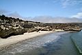
A beautiful beach by the pier
-
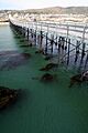
The pier at Santa Rosa Island
-
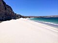
A white sand beach on the island
-
A view from the top of Torrey Pines Hill
-
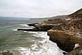
Cliffs on the northern part of the island
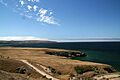
-
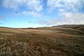
A scenic view of the island
-
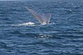
Whale watching around the island, showing a humpback whale's tail
-
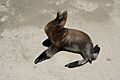
A California sea lion by the pier


See also
 In Spanish: Isla Santa Rosa (California) para niños
