
Tunxis Trail facts for kids
Quick facts for kids Tunxis Trail |
|
|---|---|

Cussgutter Brook in Winter - Tunxis Compounce Cascade Side Trail
|
|
| Length | 79 mi (127 km) |
| Location | Hartford / New Haven counties, Connecticut, USA |
| Designation | CFPA Blue-Blazed Tunxis Trail System |
| Use | hiking, cross-country skiing, snowshoeing, other |
| Highest point | Pine Mountain, 1,378 ft (420 m) |
| Lowest point | Farmington River, 150 ft (46 m) |
| Difficulty | easy, with difficult sections |
| Season | easiest spring to fall |
| Hazards | hunters, deer ticks, poison ivy |
The Tunxis Trail is a super long hiking path in Connecticut. It's about 79 miles (127 km) long! This trail is part of the "Blue-Blazed" trail system. It winds along the western side of the central Connecticut Valley.
The Tunxis Trail is actually a group of 18 different trails. One main trail goes from north to south. There are also many shorter side trails. Even though it's easy to get to, the trail feels wild and has amazing views. It's known for being rugged and very scenic.
Along the trail, you can see cool places like Lake Compounce Amusement Park. There's also "Tory Den" and the "Mile of Ledges." You'll find old cemeteries, caves, and beautiful waterfalls. The trail goes through forests, swamps, lakes, and even farmlands. You can also visit historic spots and climb to the tops of Pine Mountain and Southington Mountain. The Connecticut Forest and Park Association helps keep the Tunxis Trail in great shape.
The Tunxis Trail system is the longest of the Blue-Blazed Trails. It runs right next to the Metacomet Trail. This means you can often see views of the Metacomet Ridge from the Tunxis Trail.
Contents
Exploring the Tunxis Trail: What to Expect

The Tunxis Trail stretches from the border of Connecticut and Massachusetts. It goes through many towns as it heads south. These towns include Hartland, Barkhamsted, New Hartford, Canton, and Burlington. It also passes through Harwinton, Plymouth, Bristol, and Southington. Two smaller side trails even reach into Wolcott.
The very start of the trail in the south is near the Mount Southington ski resort. It's in Southington, Connecticut. The northern end of the trail is at the Connecticut/Massachusetts state line. This is where Tunxis State Forest meets Granville State Forest. From many parts of the Tunxis Trail, you can see the Metacomet Ridge to the east. This includes famous spots like the Hanging Hills.
Many shorter hiking trails connect with the Tunxis Trail. These are in the southern parts of the system. You can find them in the Southington area, near Lake Compounce, and in Nepaug State Forest.
People mostly use the Tunxis Trail for hiking and backpacking. It's also great for picnics and snowshoeing in winter. Some parts are good for mountain biking and cross-country skiing. Other activities include hunting, fishing, and swimming in certain areas.
Trail Highlights: What You'll See
-
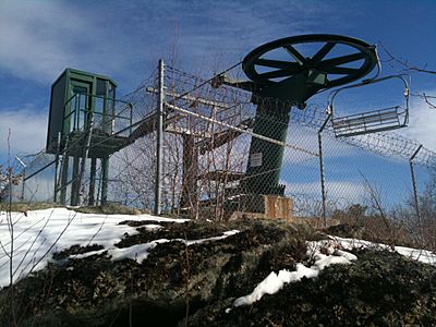
"Sky Ride" (Lake Compounce chair lift) on Southington Mountain along Tunxis Trail (2010)
-
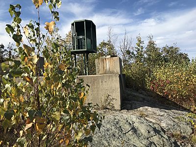
Decommissioned "Sky Ride" (Lake Compounce chair lift) on Southington Mountain along Tunxis Trail (2019)


The Tunxis Trail follows the western edge of the central Connecticut valley. This valley goes all the way from Long Island Sound up to the Massachusetts/Vermont border. This western ridge is a big part of the landscape in western central Connecticut. It looks out over the Connecticut River, Farmington River, and Quinnipiac River valleys.
As you travel the trail from south to north, you'll go near or over several mountains. These include Southington Mountain, Johnnycake Mountain, and Pine Mountain. The Farmington River cuts through the trail at Satan's Kingdom Recreation Area.
The Tunxis Trail goes through several state forests. These include Session Woods Wildlife Management Area and Tunxis State Forest. You'll also cross land owned by preservation groups and private owners. From high points, you can see farms, towns, rivers, and even the Berkshires.
Towns Along the Trail

The Tunxis Trail passes through many towns in Connecticut. From south to north, these towns are:
- Southington
- Wolcott
- Bristol
- Plymouth (also known as Terryville)
- Harwinton
- Burlington
- Canton
- New Hartford
- Barkhamsted
- Hartland
It also touches Granville, Massachusetts at its northern end.
History and Fun Stories of the Tunxis Trail
What Does "Tunxis" Mean?
The name "Tunxis" comes from a Native American language. It means "the point where the river bends." This refers to a spot on the Farmington River. The river was even called the Tunxis River by early English settlers.
"Tunxis" was also the name of a Native American sub-tribe. They lived in the area where Farmington and Southington are today. They were part of the Saukiogs tribe. In 1645, the town of Farmington was named. Land was set aside for the "Tunxis Indians" near "Indian Neck." You can learn more about the Tunxis people on their Wikipedia page.
Historic Places Along the Trail

There's a lot of history from the American Revolutionary War along the trail. The "Tory Den" is a cool boulder cave. It's located near the "Miles of Ledges." This cave was a secret hiding place for Loyalists during the war. Loyalists were people who supported the British King.
Trail Folklore: Spooky Names!
You might notice some interesting names along the Tunxis Trail. Many places have names like "Devil's Kitchen" or "Satan's Kingdom." These names usually come from colonial times.
- The "Devil's Kitchen" is a unique canyon formation. The Blue-Blazed Orange Dot Trail goes right through it.
- "Satan's Kingdom" was once thought of as a place for outlaws. Today, it's a popular spot for white-water tubing on the Farmington River.
- The Ski Sundown ski area was even called Satan's Ridge Ski Area when it first opened!
Hiking the Tunxis Trail: Tips for Your Adventure

The main Tunxis Trail is marked with blue rectangles. It's kept in good condition. Most of the trail is easy to hike. However, some parts are rugged and more challenging. For example, the "Mile of Ledges" in Burlington requires some rock climbing. The northern 20 miles are also higher up and have more elevation changes.
The Tunxis Trail is usually close to public roads. But in the Burlington area, many roads are unpaved. The northernmost 20 miles are much more remote. You can find places to camp in the northern parts of the trail. These are in Nepaug and Tunxis State Forests. Camping is generally not allowed in the southern sections. You can find guidebooks and maps from the Connecticut Forest and Park Association.
The trail has roughly four main sections:
- Southington (Southington, Wolcott, Bristol)
- Burlington (Plymouth, Harwinton, Burlington)
- Nepaug (Burlington, New Hartford)
- The northern 20 miles (New Hartford, Canton, Barkhamsted, Hartland)
Weather and Safety on the Trail
The weather along the trail is typical for Connecticut. It can be colder or stormier on exposed ridge tops. Lightning can be dangerous on open summits during thunderstorms. Snow is common in winter, so you might need snowshoes. Ice can form on ledges, making hiking tricky without special gear.
In late winter or early spring, the trail can get very muddy. Ponds and streams might overflow. It's a good idea to wear tall waterproof boots then.
Biting insects can be annoying in warm weather. Be aware of deer ticks, which can carry Lyme disease. Always check yourself for ticks after a hike.
Some parts of the trail are very close to towns and homes. You might see ruts from ATVs in the southern sections. The middle sections have many forest roads and dirt roads. The Nepaug section has some interesting sights, like many rock piles (cairns).
Much of the trail is on land where hunting is allowed. It's a good idea to wear bright orange clothing during hunting season. This is usually from fall through December.
Protecting the Tunxis Trail

