Wantage Township, New Jersey facts for kids
Quick facts for kids
Wantage Township, New Jersey
|
||
|---|---|---|
|
Township
|
||
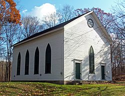
Old Clove Presbyterian Church
|
||
|
||
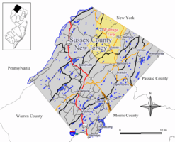
Location of Wantage Township in Sussex County highlighted in yellow (right). Inset map: Location of Sussex County in New Jersey highlighted in black (left).
|
||
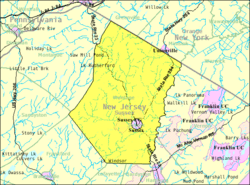
Census Bureau map of Wantage Township, New Jersey.
|
||
| Country | ||
| State | ||
| County | ||
| Formed | May 30, 1754 (as precinct) | |
| Incorporated | February 21, 1798 | |
| Named for | Wantage, England | |
| Government | ||
| • Type | Township | |
| • Body | Township Committee | |
| Area | ||
| • Total | 67.48 sq mi (174.78 km2) | |
| • Land | 66.76 sq mi (172.91 km2) | |
| • Water | 0.72 sq mi (1.87 km2) 1.07% | |
| Area rank | 18th of 565 in state 2nd of 24 in county |
|
| Elevation | 538 ft (164 m) | |
| Population
(2020)
|
||
| • Total | 10,811 | |
| • Estimate
(2023)
|
10,993 | |
| • Rank | 233rd of 565 in state 4th of 24 in county |
|
| • Density | 161.9/sq mi (62.5/km2) | |
| • Density rank | 516th of 565 in state 18th of 24 in county |
|
| Time zone | UTC−05:00 (Eastern (EST)) | |
| • Summer (DST) | UTC−04:00 (Eastern (EDT)) | |
| ZIP Code |
07461
|
|
| Area code(s) | 973 | |
| FIPS code | 3403776790 | |
| GNIS feature ID | 0882257 | |
| Website | ||
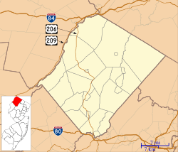
Wantage Township (pronounced WHAN-tij) is a community in Sussex County, New Jersey. It's called a township, which is a type of local government area.
In 2020, about 10,811 people lived in Wantage. This number was a little lower than in 2010.
Wantage Township was first set up on May 30, 1754. It became an official township on February 21, 1798. The township was named after a town called Wantage in England.
Contents
Exploring Wantage Township's Geography
Wantage Township covers about 67.48 square miles (174.78 km2). Most of this area is land, with a small part being water.
The township is located in the Kittatinny Valley. This valley is part of the larger Great Appalachian Valley. This huge valley stretches for about 700 miles from Canada to Alabama.
Communities and Landmarks in Wantage
Many small communities and places are found within Wantage Township. These include Beemerville, Colesville, Hanford, and Lake Neepaulin. Other spots are Lake Rutherford, Lewisburg, Libertyville, and Martins. You can also find Mount Salem, Papakating, Quarryville, Rockport, Roys, and Woodbourne.
Rutan Hill: New Jersey's Only Volcano Site
Near the Beemerville area of Wantage Township is Rutan Hill. It's also known as Volcanic Hill. This is New Jersey's only place where a volcano was once active. It last erupted over 440 million years ago!
Rivers and Streams in Wantage
The rivers and streams in Wantage Township flow into the Wallkill River. These waterways include:
- Papakating Creek
- West Branch Papakating Creek
- Neepaulakating Creek, which was dammed to create Lake Neepaulin.
- Clove Brook, which was dammed to create Clove Acres Lake.
Wantage: A "Doughnut Town"
Wantage Township completely surrounds Sussex borough. This means Sussex borough is like the "hole" in a doughnut, and Wantage Township is the "doughnut" around it. This is one of 21 such "doughnut towns" in New Jersey.
Wantage shares borders with several other towns. These include Frankford Township, Hardyston Township, and Lafayette Township. It also borders Montague Township, Sandyston Township, and Vernon Township in Sussex County. Wantage also touches Greenville and Minisink in Orange County, New York.
Wantage Township Population and People
| Historical population | |||
|---|---|---|---|
| Census | Pop. | %± | |
| 1810 | 2,969 | — | |
| 1820 | 3,307 | 11.4% | |
| 1830 | 4,034 | 22.0% | |
| 1840 | 3,908 | −3.1% | |
| 1850 | 3,934 | 0.7% | |
| 1860 | 3,862 | −1.8% | |
| 1870 | 3,636 | −5.9% | |
| 1880 | 3,361 | −7.6% | |
| 1890 | 3,412 | 1.5% | |
| 1900 | 2,217 | * | −35.0% |
| 1910 | 2,077 | −6.3% | |
| 1920 | 1,898 | −8.6% | |
| 1930 | 2,075 | 9.3% | |
| 1940 | 2,376 | 14.5% | |
| 1950 | 2,543 | 7.0% | |
| 1960 | 3,308 | 30.1% | |
| 1970 | 4,329 | 30.9% | |
| 1980 | 7,268 | 67.9% | |
| 1990 | 9,487 | 30.5% | |
| 2000 | 10,387 | 9.5% | |
| 2010 | 11,358 | 9.3% | |
| 2020 | 10,811 | −4.8% | |
| 2023 (est.) | 10,993 | −3.2% | |
| Population sources: 1810–1920 1840 1850–1870 1850 1870 1880–1890 1890–1910 1910–1930 1940–2000 2000 2010 2020 * = Lost territory in previous decade. |
|||
In 2010, there were 11,358 people living in Wantage Township. There were 3,910 households, which are groups of people living together. Most households (66.8%) were married couples.
About 34.7% of households had children under 18. About 15.8% of households were single people living alone. The average household had 2.90 people.
The population was mostly White (95.23%). About 5.23% of the population was Hispanic or Latino.
The median age in Wantage Township in 2010 was 41.2 years old. This means half the people were younger than 41.2, and half were older.
Education in Wantage Township
Students in Wantage Township go to public schools in the Sussex-Wantage Regional School District. This district also includes students from Sussex Borough.
Elementary and Middle Schools
The district has three schools for students from kindergarten through eighth grade:
- Clifton E. Lawrence School: Located in Wantage, this school teaches students in grades K-2.
- Wantage Elementary School: Also in Wantage, this school serves students in grades 3-5.
- Sussex Middle School: Located in Sussex, this school is for students in grades 6-8.
High School Education
For high school, students from Wantage and Sussex attend High Point Regional High School. This school also welcomes students from nearby towns like Branchville, Frankford Township, Lafayette Township, and Montague Township.
The high school has a board of education with nine members. Seven of these seats are for representatives from Wantage Township.
Getting Around Wantage Township
Roads and Highways
Wantage Township has many roads. In 2010, there were over 172 miles of roads. The township itself takes care of most of these roads.
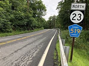
Major roads that go through Wantage include Route 23, Route 284, County Route 519, and County Route 565. Route 284 connects to a similar road in New York, which helps people get to U.S. Route 6.
Aviation: Sussex Airport
Sussex Airport is a small airport located right in Wantage Township. It's mainly used for general aviation, which means smaller, private planes.
Ventimiglia Vineyard: A Local Winery
- Ventimiglia Vineyard is a winery located in Wantage Township.
Notable People from Wantage Township
Many interesting people have lived in or are connected to Wantage Township. Here are a few:
- Nick Boyle (born 1993): A professional football player who played as a tight end for the Baltimore Ravens.
- Lou Dobbs (1945-2024): A well-known radio and television host.
- Scott Garrett (born 1959): He used to be a U.S. Representative for New Jersey, serving in Congress from 2003 to 2017.
- Hugh Judson Kilpatrick (1836–1881): An officer in the Union Army during the American Civil War. He reached the rank of major general.
- Parker Space (born 1968): A politician who has represented the 24th Legislative District since 2024. He also served as Mayor of Wantage Township.
- Moses D. Stivers (1828–1895): A businessman and politician who served one term in the U.S. Congress.
- Hal Wirths (born 1965): A politician who represented the 24th Legislative District in the New Jersey General Assembly.
See also
 In Spanish: Municipio de Wantage para niños


