West Lakes, South Australia facts for kids
Quick facts for kids West LakesSouth Australia |
|||||||||||||||
|---|---|---|---|---|---|---|---|---|---|---|---|---|---|---|---|
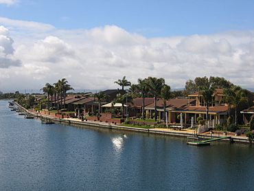
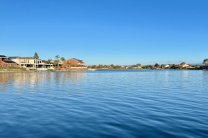
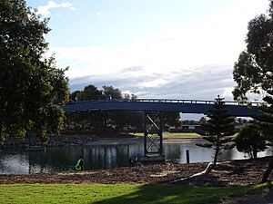
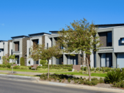
Looking north-east across the tidal lake onto Delfin Island. Examples of the original architectural styles found in West Lakes can still be observed
|
|||||||||||||||
| Established | 30 September 1976 | ||||||||||||||
| Postcode(s) | 5021 | ||||||||||||||
| Time zone | ACST (UTC+9:30) | ||||||||||||||
| • Summer (DST) | ACST (UTC+10:30) | ||||||||||||||
| LGA(s) | City of Charles Sturt | ||||||||||||||
| State electorate(s) | Lee | ||||||||||||||
| Federal Division(s) | Hindmarsh | ||||||||||||||
|
|||||||||||||||
|
|||||||||||||||
| Footnotes | Adjoining suburbs | ||||||||||||||
West Lakes is a western suburb of Adelaide, South Australia. It is part of the City of Charles Sturt.
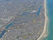
This area was built in the 1970s. It was a project between the government and a private company. West Lakes is famous for its large, man-made tidal lake. It also has Delfin Island, which is a residential island in the middle of the lake. The lake was later named John Dyer Lake. This was to honour John Raymond Dyer, a former Mayor who helped a lot with the area's development.
Today, West Lakes has the Westfield West Lakes shopping centre. It also has the Woodlake Shopping Centre and the West Lakes Golf Club. The Adelaide Football Club uses the former AAMI Stadium (Football Park) as its training ground here.
West Lakes has an unusual shape. It shares borders with Port Adelaide, Queenstown, Royal Park, Seaton, and Grange. Other nearby suburbs with lake views include Semaphore Park, Tennyson, and West Lakes Shore.
Contents
The Story of West Lakes
West Lakes was built on what used to be the River Torrens Wetlands. These wetlands were also known as the Reedbeds. This happened many years after the Torrens River was moved to flow into the sea at West Beach. Before West Lakes was built, the area was mostly swampy marshland. There were also sandy dunes along the coast.
A property developer called Delfin (now Lendlease Communities) led this big building project. It was a joint effort with the Government of South Australia. The name "West Lakes" comes from the tidal lake and its location in western Adelaide. The plan for West Lakes became official with the West Lakes Development Act in 1969.
Building work started in September 1970. About 10 million tonnes of earth were moved. This created the tidal lake and made land ready for building houses.
Building on Reclaimed Land
Because West Lakes was built on reclaimed marshland, special care was taken in engineering the houses. At first, only one or two-storey homes could be built. Taller buildings, like the shopping centre and apartments, had their own special areas.
Many houses used "raft foundations." These are special foundations that help stop buildings from sinking or moving. This was important because of the soft soil.
Delfin had rules about how houses should look. These rules were part of the land titles. They made sure that the houses matched their vision for each neighbourhood. West Lakes was also one of the first places in South Australia to have power and telephone lines underground.
The rules also controlled where things like clotheslines and TV aerials could be placed. They also banned fences at the front of properties.
West Lakes officially opened on March 18, 1977. The Deputy Premier, Des Corcoran, opened it. The West Lakes Post Office opened earlier, in August 1975.
Awards and Development
In 1992, the West Lakes project won a special award called the Prix D’Excellence. This award came from FIABCI, the International Real Estate Federation. West Lakes was praised for bringing together all parts of real estate. It was also noted for its positive impact on the environment and the lives of its residents.
A sign about this award was displayed until the 2010s. The building of the "WEST" housing area led to its removal. The development of West Lakes took a long time, from 1970 to 2001. This was a total of 31 years.
Soil Concerns
In 2000, tests showed that the soil around the old Port Adelaide Wastewater Treatment Plant had cadmium. This affected about 200 homes. Cadmium got into the soil from sludge during the early building work in the 1970s. The government suggested ways to reduce exposure to it.
In 2020, another chemical, per- and polyfluoroalkyl substances (PFAS), was found. This was in the groundwater, soil, and sewage sludge in the same area. The authorities told residents that the same steps for cadmium would help with PFAS.
Tests showed that PFAS had contaminated the groundwater. Residents were told not to use groundwater. However, lake water, tap water, and rainwater were safe. Fish from the lake were also safe to eat, as PFAS levels were very low.
The Tidal Lake
The large freshwater lake is a key feature of West Lakes. At the southern end, an underground pipe connects the lake to Tennyson Beach.
When the sea tide is high, seawater flows into the lake through this pipe. An automatic gate opens to let the water in. When the tide is low, the gate closes. Then, at the northern end of the lake, another gate opens. This allows water to flow out into the Port River. This system flushes about 410 megalitres of fresh seawater through the lake every day.
The lake started filling in November 1974. This was just before the Westfield West Lakes shopping centre opened. The first time ocean water flowed in, it was not filtered. This meant many different types of marine life entered the lake. A large stingray was even seen, which some people thought was a shark. Because the lake was meant for swimming, larger marine animals like the stingray were caught and moved.
Today, only smaller marine life can enter the lake from the ocean. There are special spots around the lake for people who like to fish. After it rains, it is best to avoid swimming in the lake for 2-3 days. This is because of polluted stormwater runoff.
A.M. Ramsay Regatta Course
The lake was designed to include an international-standard rowing course. The wide, straight southern part of the lake is a 2-kilometre rowing course. It is called the A.M. Ramsay Regatta Course. It hosts the yearly Head of the River race.
Delfin Island
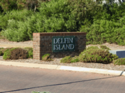
Delfin Island opened on March 17, 1978. It was named after the company that built West Lakes. This 106-hectare artificial residential island is special in South Australia. Similar man-made islands exist in places like the Gold Coast. Early plans for West Lakes did not originally include a residential island.
After the island was formed, two more peninsulas were created. This was done by digging more at the north and south ends of the island. This made more waterfront land available for homes.
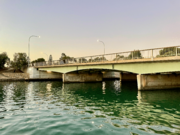
Delfin Island is connected to the mainland by one road, West Lakes Boulevard. There are also two pedestrian bridges. One is on the west side, linking Bartley Terrace to Keppel Grove. The other is on the east, linking Lochside Drive to Kerr Grove and Corcoran Drive.
The Island Point apartment complex was finished in 1990. It is a tall building at the southern end of the island. It was one of the first high-rise apartment buildings in suburban South Australia.
Freshwater Lake, also known as the Delfin Island duck ponds, is on the island. It covers about 3 hectares.
The island mostly has quiet cul-de-sacs in different "neighbourhoods." Homes here are usually more expensive than in other parts of West Lakes.
Many of the roads on the island are named after countries in the Caribbean and Polynesia. They are also named after other exotic islands like Corfu and Bali.
West Lakes Boulevard
West Lakes Boulevard is the main road through the area. It goes from Port Road in the east to Military Road in the west.
This road was first planned to go through the nearby suburb of Albert Park. However, residents protested. So, the route was changed to use (and rename) part of Clark Terrace. This road runs next to the Grange railway line.
A train line was planned to run next to West Lakes Boulevard. It would have ended near the shopping centre. But this did not happen because of money problems. The land saved for the train line became Magarey Grove. This is a line of 100 spotted gum trees. Each tree is dedicated to one of the first 100 winners of the Magarey Medal.
New Housing Areas
WEST Development
In 2015, a property developer started building a new area called "WEST." This area is on the land where Football Park used to be.
The WEST development is located near Frederick Road, West Lakes Boulevard, Brebner Drive, and the old Football Park. This area used to have the Crows Shed, a large grass oval, and a grandstand.
Most of the homes here are townhouses and apartments. This is different from the original West Lakes, which had mostly single-family houses. WEST is a more crowded area. It has smaller blocks of land and more attached homes. This shows modern urban planning ideas.
The WEST area also has a City of Charles Sturt library. There are shops, restaurants, a childcare centre, and a place for aged care.
A small decorative lake was also built here. It is not connected to the main tidal lake. It uses machines to keep the water flowing and oxygenated.
Brebner Drive was moved to go through the new area via Troubridge Drive. This made space for a walking trail next to the Grange Golf Club. This change kept a direct link between Frederick Road and Westfield West Lakes.
Novo West Lakes
In March 2024, a new housing development called Novo West Lakes was announced. It will be built on the 17-hectare site of the former Port Adelaide Wastewater Treatment Plant. This area is next to Frederick Road, the tidal lake, and existing homes.
Almost 500 new homes, including townhouses and apartments, will be built. One of the old buildings on the site will become a pub. This will be part of a new shopping and dining street.
This development is part of a plan by the state government to release land for housing. The old wastewater site is good for housing because it is close to the Osborne Naval Shipyard. Submarines for the AUKUS project will be built there for the Royal Australian Navy. The first submarine is expected in the early 2040s.
Fun Things to Do
Besides Westfield West Lakes, the suburb has the Lakes Resort Hotel (built in 1985). It also has the West Lakes Golf Club, one of several in the western suburbs.
West Lakes was home to Football Park (also known as AAMI Stadium). This was a large sports stadium with 51,240 seats. AFL and SANFL games were played there. The main parts of the stadium were taken down in 2019. The oval itself is still there. It is now the main training ground for the Adelaide Football Club.
There used to be a Douglas C-47 Skytrain military plane at the McDonald's next to Westfield West Lakes. It was part of a play area for children's parties. The plane was removed in the late 1990s and is now being restored.
People of West Lakes
The 2021 Census showed the population of West Lakes was .
About 47% of the people were male, and 53% were female. The average age in West Lakes is 54. This is 13 years older than the average age in South Australia.
The average household income per week was $1,548. About 27% of West Lakes residents had completed higher education.
71% of residents were born in Australia. The next most common birthplaces were England (6%), Italy (2%), China (1.7%), and Germany (1.2%). About 0.9% of West Lakes residents identified as Indigenous Australians.
Getting Around
Westfield West Lakes has a bus station. Other parts of the suburb are served by various bus routes. These routes connect to other suburbs and the city.
|
|
|
 | Georgia Louise Harris Brown |
 | Julian Abele |
 | Norma Merrick Sklarek |
 | William Sidney Pittman |


